| The
Structure
Plan identifies
Chester
as
an
area
where
more
investment
is
needed
in
small
scale
improvements
for
provision
of
countryside
recreation
on
the
fringe
of
the
urban
area.
The Greater
Chester
District
Plan identifies
Blacon
and
Hoole
as
as
areas
where
there
should
be
additional
parks
or
informal
open
spaces.
Horses Any provision for safe riding is clearly welcomed. Guilden Sutton Parish Council have requested that the line in their area be converted for such use. If some footpaths linking the line with minor roads were upgraded to bridleway, and provided with a suitable surface, attractive safe cross-country routes could be created from Chester into Wirral and to Delamere Forest. Natural
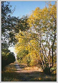
History Most
of
the
route
passes
through
banks
of
trees
and
bushes
which
attract
birds
and
insects.
There
are
many
common
wildflowers.
Immediately,
therefore
the
line
has
interest
for
the
natural
historian.
Careful
development
could
enhance
this
interest.
Sympathetic
management
linked
to
interpretation
could
create
a
'reserve'
of
considerable
interest
to
the
average
walker
and
for
those
concerned
with
natural
history
education. Management In order to combat vandalism motorcycling would be prohibited and the Urban Path would be under Ranger management. The maintainance of the path would be the responsiibility of the Highways Department... Landscaping The
margins
of
the
land
surface
adjacent
to
the
path
would
be
allowed
to
merge
into
adjacent
planting
to
avoid
a
hard
edge
to
the
path.
Due
to
the
constraints
imposed
by
embankments
and
cuttings,
the
only
immediate
landscape
work
would
be
extensive
planting.
Trees
and
shrubs
could
be
planted
to
frame
views
and
to
provide
shelter
on
the
more
exposed
lengths.
Shrub
planting
could
be
allowed
to
encroach
so
that
long
vistas
on
straight
portions
of
the
path
are
broken
up. The urban path would provide a safe and convenient route for pedestrians and cyclists from residential areas into the city centre. It would benefit the people of Chester, make a contribution to provision for the 'leisure age' and create a new focus for tourism...
July 1998: You should try to obtain the full version of the above report- we found it in the reference section of Chester Library. It is a well-reasoned, intelligent document that makes fascinating reading. In the fourteen years since it was written there has been a great increase in environmental awareness, but at the same time a considerable worsening in traffic conditions for pedestrians and cyclists- there currently exists virtually nowhere at all in Chester where this writer can cycle in peace and safety with his two small daughters- and a reduction in the green open space thanks to the attentions of developers. Our worthy representatives could do worse than to dig out dusty copies of the above report and read it carefully. The course of action it advocates is exactly what is needed to give Chester's citizens just for once somewhere they and their children may walk and cycle in peace- safe from stinking, recklessly driven cars and buses- and at considerably less cost than the lunatic busway scheme. Is that really too much to ask? Now you can see the place for yourself! Take 'A Virtual Stroll Along the Mickle Trafford Railway'
A growing collection of letters to these pages and the Chester press in favour of the busway and- far more numerous!- letters against it. A true and accurate indication of public opinion! |
 Cyclists
are
badly
catered
for
in
the
countryside and
the
government
is
urging
local
authorities
to
make
use
of
disused
railway
lines
to
provide
cycling
facilities.
The
potential
of
Cheshire
as
a
tourist
attraction
for
cyclists
has
only
recently
been
recognised.
Cyclists
are
badly
catered
for
in
the
countryside and
the
government
is
urging
local
authorities
to
make
use
of
disused
railway
lines
to
provide
cycling
facilities.
The
potential
of
Cheshire
as
a
tourist
attraction
for
cyclists
has
only
recently
been
recognised.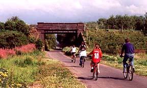 Construction If
the
existing
railway
ballast
is
left
in
place,
then
a
satisfactory
hard
surface
could
be
provided
by
reshaping
the
ballast,
binding
with
a
fine
granular
material
and
surfacing
with
tarmac.
The
path
would
be
three
metres
wide
with
the
remaining
width
of
ballast
being
soiled
over
to
provide
a
grassed
margin.
Construction If
the
existing
railway
ballast
is
left
in
place,
then
a
satisfactory
hard
surface
could
be
provided
by
reshaping
the
ballast,
binding
with
a
fine
granular
material
and
surfacing
with
tarmac.
The
path
would
be
three
metres
wide
with
the
remaining
width
of
ballast
being
soiled
over
to
provide
a
grassed
margin.