 he
ancient
and
beautiful
city
of
Chester is
situated
in
north
west
England,
close
to
the
border
with
North
Wales.
In
addition
to
its
unique
covered
galleries,
known
as
the Rows, and
countless
other
architectural
gems,
the
city
possesses
the
most
complete
circuit
of
Roman,
Saxon
and
medieval
city
walls
in
Britain. he
ancient
and
beautiful
city
of
Chester is
situated
in
north
west
England,
close
to
the
border
with
North
Wales.
In
addition
to
its
unique
covered
galleries,
known
as
the Rows, and
countless
other
architectural
gems,
the
city
possesses
the
most
complete
circuit
of
Roman,
Saxon
and
medieval
city
walls
in
Britain.
Many
are
the
legends
associated
with
the
city's
origins.
To
quote
the
authors
of
the
1792
Chester
Directory, Barfoot
and
Wilkes, "The
ancient
name
of
this
city,
it
is
said,
was
Neomagus,
so
called
from
Magus,
son
of
Samothes,
son
of
Japet
(himself
a
son
of
Noah)-
its
founder,
240
years
after
the
Flood;
an
assertion
which,
if
authenticated,
places
Chester
on
a
line
of
antiquity
with
any
other
city
in
the
universe"
Around
the
year
1500,
Brother Henry
Bradshaw,
quoting
an
earlier
Chester
monk, Ranulf
Higden's Polychronicon ('Universal
History')
which
was
written
around
1350,
says: "The
founder
of
this
city,
as
saith
the
Polychronicon,
was
Leon-Gawer,
a
mighty
strong
gyant,
a
man
beyond
the
moon
and
called
by
Marius
the
vanquisher
of
the
Picts,
who
builded
caves
and
dungeons
many
a
one;
no
goodly
building,
ne
proper,
ne
pleasant.
But
King
Leir (Shakespeare's
King
Lear) -
a
Briton
fine
and
valiant,
was
founder
of
Chester
by
pleasant
building,
which
was
named
Guer
Leir
by
the
King"
Chester
owes
its
existence
largely
to
the
strategic
importance
of
its
site,
a
promontory
of
Old
Red
Sandstone
surrounded
on
the
west
and
south
by
the River
Dee and
first
recognised,
as
far
as
we
know
for
certain,
2000
years
ago
by
the
Roman
Legions.
Almost
certainly
the
site
must
have
been
inhabited
well
before
that
time,
but
in
a
place
where
virtually
every
square
inch
of
land
has
been
built
and
rebuilt
upon
many
times
over
the
centuries,
positive
evidence
is
most
difficult
to
uncover,
although
shards
of
pottery
discovered
in Abbey
Green were
identified
as
dating
from
Neolithic
times
(c.4000-2400BC),
making
them
the
first
examples
of
pottery
of
this
period
known
from
Cheshire,
and
a
graphic
illustration
of
how
people
from
earliest
times
recognised
and
utilised
the
defensive
possibilities
of
this
sandstone
plateau
above
the
River
Dee.
The
nature
of
any
settlement
of
"Painted
Britons"-
the
local
tribal
groups
were
known
as
the Cornovii-
encountered
here
by
the
first
Romans
may
be
imagined
from
the
commentaries
of Julius
Caesar,
who
famously
landed
in
Britain
in
55BC: "A
town
amongst
the
Britons
is
nothing
more
than
a
thick
wood
fortified
with
a
ditch
and
ramparts,
to
serve
as
a
place
of
retreat
against
the
incursions
of
their
enemies"-
and
by
the
Roman
historian Strabo:
"When
they
have
enclosed
a
large
circuit
in
their
forests
with
felled
trees,
they
build
within,
houses
for
themselves
and
hovels
for
their
cattle".
It
must
be
said,
however,
that,
though
we
know
virtually
nothing
about
the
local
tribes,
many
of
the
indiginous
peoples
of
the
British
Isles
at
this
time
were
highly
cultured-
skilled
poets
and
fine
craftsmen.
It
was
probably
in
Caesar's
interest,
as
with
would-be
conquerors
before
and
since,
to
make
out
he
was
dealing
with
a
barbarian
population;
such
dispatches
would
doubtless
go
down
well
in
Rome
with
those
interested
parties
putting
up
the
money
for
his
wars.
In
addition,
placing
the
Iron
Age
inhabitants
of
the
future
site
of
Chester
within
the
tribal
territory
of
the Cornovii may
merely
have
been
an
administrative
convenience-
such
'tidying
up'
is
known
to
have
occured
elsewhere
in
the
Roman
Empire-
and
the
pre-conquest
peoples
may
equally
well
have
been
allied
to
the Coritani or Brigantes to
the
east
(whose
territory
stretched
"from
coast
to
coast")
or
the Ciangi to
the
east-
or
may
have
preserved
a
considerable
degree
of
independence.
 As
previously
observed,
the
future
site
of
Chester
would
have
attracted
settlers
from
earliest
times,
but
the Roman military presence at Chester probably began with a fort or marching camp at the mouth of the Deva Fluvius (River Dee) very likely established during the early campaigns of governor Publius Ostorius Scapula against the Deceangi in north-east Wales sometime around AD47/48. There is some evidence of pre-Flavian occupation, possibly even a timber-built fort, but proof positive of a Scapulan foundation has yet to emerge. As
previously
observed,
the
future
site
of
Chester
would
have
attracted
settlers
from
earliest
times,
but
the Roman military presence at Chester probably began with a fort or marching camp at the mouth of the Deva Fluvius (River Dee) very likely established during the early campaigns of governor Publius Ostorius Scapula against the Deceangi in north-east Wales sometime around AD47/48. There is some evidence of pre-Flavian occupation, possibly even a timber-built fort, but proof positive of a Scapulan foundation has yet to emerge.
After the first tentative forays of Scapula, the next military activity in the area was conducted during the early administration of governor Sextus Julius Frontinus sometime around AD74 when an auxiliary fort was constructed at Chester. The placement of this fort was a strategic move by Frontinus designed both to block the route of any routed British bands trying to escape to the north, and also to guard against any help arriving from the Brigantes.
By AD79 the site had developed into the twenty-five hectare fortress base of Legio II Adiutrix Pia Fidelis ('Dutiful
and
Faithful'). Archaeological
evidence
indicates
that
it
was
laid
out
over
the
cultivated
fields
of
the
shadowy
former
inhabitants.
Titus was Emperor in Rome, Jerusalem had been captured and destroyed five years earlier, St. Peter was ten years dead and the Gospels of Matthew and John lay ten years into the future.
They called their new fortress Deva or Dewa ('The Goddess') after the native people's name for the the then-great river dominating the site: the Dyfrdwy- the Dee, as we know it now. Water sources in general and rivers in particular were deemed to be sacred places and the habitations of supermortal beings and, to this day, most British rivers have retained their ancient Celtic names.
The external dimensions of their fortress were 1,950 x 1,360 feet (594 x 415 m), which, allowing for the width of the defences gave an interior area of about 56 acres (22.7 hectares). This early Flavian timber fortress is evidenced by lead piping bearing the name of Gnaeus Julius Agricola.
Around AD87 the Second Legion was withdrawn from Britain by the Emperor Domitian to be used in his wars in Dacia, and to replace them at Chester with Legio XX Valeria Victrix ('Strong and Victorious') were forced to abandon their newly-built fortress at Inchtuthil on the Tay, and were withdrawn from Scotland in order to maintain a strong legionary presence outside North Wales.
 The fortress was rebuilt in stone around AD102, during the reign of Trajan. These defenses consisted of a massive stone wall, fronted by a double ditch and backed by a rampart of sand and clay. Antonine pottery of c.170 confirms occupation in the latter half of the second century. Further reconstruction is recorded on an inscription of Elagabalus (c.235) and repairs were made to the fortress wall c.301-306. By 383 the silting up of the river Dee was a major factor in the abandonment of the Deva Fortress. The fortress was rebuilt in stone around AD102, during the reign of Trajan. These defenses consisted of a massive stone wall, fronted by a double ditch and backed by a rampart of sand and clay. Antonine pottery of c.170 confirms occupation in the latter half of the second century. Further reconstruction is recorded on an inscription of Elagabalus (c.235) and repairs were made to the fortress wall c.301-306. By 383 the silting up of the river Dee was a major factor in the abandonment of the Deva Fortress.
Rebuilding
and
expansion
of
the
fortress
continued
throughout
the
centuries
of
occupation
and,
in
its
final
form,
Deva
would
have
covered
an
area
of
about
65
acres.
With
its
imposing
walls
and
great
buildings,
it
must
have
been
a
breathtaking
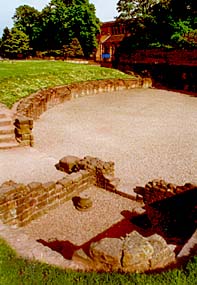
sight. A large amphitheatre outside the south-east corner of the fortress could seat eight thousand people.
Such was the size of the fortress and grandeur of its architecture, and especially of such unique structures as the Elliptical Building (whose remains were outrageously obliterated when the ironically-named Forum council offices were constructed in the 1960s) it is strongly surmised that Deva was being prepared to become the capital city of Roman Britain.
Its occupants, despite hailing from every corner of the known world, were all (with the obvious exception of the slaves) counted as Citizens of Rome, and therefore enjoyed rights, laws and a standard of living the likes of which would not be seen again in Europe until modern times.
The basic staple of the Roman soldier was bread, and each soldier was allocated about three pounds of corn per day in order to make a nourishing type of wholemeal loaf. When in garrison at the fortress, legionaires also ate a considerable quantity of meat. During excavations over the years at Chester many bones of animals and birds and the shells of molluscs have been uncovered, proving that the soldiers had a very healthy diet. The animal bones included those of domesticated ox, sheep, goat and pig, also game animals such as red deer, roe deer, and boar, which were very likely being hunted and killed for sport. The bones of wild and domesticated fowl included those of chicken, duck, goose, pheasant and swan. The main types of seafood consumed were oysters and mussels.
There is an interesting paragraph in the second century geographical treatise by Claudius Ptolemaeus (Ptolemy) which says: "From these (the Ordovices) toward the east are the Cornavi, among whom are the towns: Deva, Legio XX Victrix 17°30 56°45 Viroconium 16°45 55°45".
The Ordovices were a savage tribe from the valleys of North Wales, against whom the legionary fortress at Chester was directed. The extract shows that the Prata Legionis, the surrounding land which came under military jurisdiction of the Twentieth Legion stationed at the Deva fortress, was appropriated from the tribal territories of the Cornovii, whose cantonal capital lay at Viroconium Cornoviorum (Wroxeter, Shropshire).
Chester also appears in two (out of fifteen) routes in the Antonine Itinerary, produced in the late 2nd century. The first mention is in Iter II, "The route from the 'Entrenchments' to the Port of Rutupiae", which details the Roman road-stations between Hadrian's Wall and the main port of embarkation for the continent at Richborough in Kent. On this route, Chester appears as Deva Leg XX Vict, which again confirms that the Twentieth Legion were garrisoned here, 20 miles from Condate (Northwich, Cheshire) and 10 miles from Bovium (Tilston, Cheshire).
One of the most interesting routes in the Itinerary is Iter XI, entitled "the route from Segontium (Caernarfon) to Deva", this seventy-four mile long route features Chester as one of its termini. Iter XI is discussed in the page for St. Asaph, the last but one station, which lies 32 miles from Chester.
It seems likely that the Chester fortress was abandoned by the legions sometime towards the end of the fourth century, and there is no mention of Deva in the Notitia Dignitatum published around the turn of the fifth. The town is mentioned in the seventh century Ravenna Cosmology, appearing as Deva Victris, between the unknown towns Saudonio and Veratino.
Major
rebuilding
of
the
north
and
west
walls
took
place
in
the
late
third
or
early
fourth
centuries-
possibly
as
a
result
of
a
period
of
abandonment-
and
at
least
one
major
building
in
the
fortress
continued
in
use
up
to
the
end
of
the
fourth
century.
Thus,
it
may
be
that
the
final
withdrawal
from
Deva
did
not
occur
until
soon
after
this
time,
possibly
by Maximus for his continental expedition of 383. It is also possible that a Legion or Legions other than the XXth garrisoned the fortress at this time. We have no way of knowing, although tombstones found built into the North Wall do provide some evidence for this.
When
the
end
finally
came,
the
deserted
Romanised
Britons
saw
the
disappearance
of
their
former
protectors,
and
the
ever-increasing
raids
of
Pictish
sea
pirates
and
neighbouring
tribes
as "a great calamity" and appealed thus to Rome for assistance: "To Aetius, thrice Consul, the groans of the Britons: the barbarians drive us to the sea, the sea throws us back onto the swords of the barbarians, so that we have nothing left us but the wretched choice of being drowned or butchered."
After
the
withdrawal
the
Legions,
and
in
common
with
many
other
English
towns,
Chester
seems
to
have
lain
deserted
for
many
years
(The
first
English
meditation
on
old
stones, The
Ruin,
an
evocative
description
of
those
times,
may
be
read here). Then,
around
the
year
893,
when
the
old
fortress
lay
within
the
Kingdom
of
Mercia, a
raiding
party
of
Danes
discovered
and
occupied
this "deserted
city
in
Wirral
which
was
called
Chester".
The
Mercians
regained
much
of
their
territory
from
the
Danes
in
the
early
tenth
century,
when,
under
Queen Aethelflaed,
Chester
was
re-fortified
as
a burgh in
907-
the
centre
of
a
line
of
lesser burghs which
stretched
from
Manchester
to
Rhuddlan
and
protected
Mercia's
northern
frontier.
This
date
marks
the
commencement
of
Chester's
development
as
an
English
 In
late
Saxon
times,
Chester
was
one
of
the
largest
and
most
important
towns
in
England
and
had
a
considerable
population
of
around
3000
inhabitants. In
late
Saxon
times,
Chester
was
one
of
the
largest
and
most
important
towns
in
England
and
had
a
considerable
population
of
around
3000
inhabitants.
(We are currently preparing a new chapter, telling the stirring story of Chester
between the times of the Romans and the Normans)
Five
hundred
years
after
the
Legions
withdrew
from
Deva,
their
Saxon
successors
knew
the
city
as Legecaester,
a
translation
of
part
of
the
British
(Welsh) Caer
Lleon
Vawr
ar
Ddyfrdwy or
'Camp
of
the
Great
Legion
on
the
Dee'-
also
called Caerleon-ar-Dour.
Long
before
the
Norman
conquest,
the
first
part
of
the
name
was
being
omitted
in
documents,
and
by
the
time
of
Henry
I
(1100-1135)
the
coinage
had
also
simplified
it
to
a
form
which
is
recognisable
as
the
modern Chester.
Our
Welsh-speaking
neighbours
however,
to
this
day
refer
to
the
city
as Caer.
A
fascinating
and
convincing
theory
was
propounded
by Robert
Stoker in
his
book The
Legacy
of
Arthur's
Chester (1963),
who
pointed
out
that
there
were
actually two cities
bearing
the
name
Caerleon,
and,
after
the
departure
of
the
Legions,
it
was
here,
Caerleon-upon-Dee
that
became
the
ecclesiastical
and
civil
capital
of
the
Kings
of
Britain,
Capital
of
Wales,
GHQ
of
the
centuries-long
campaigns
against
the
Saxons
and
the
city
of
the
coronation,
in
the
early
seventh century,
of
a
not-so-legendary King
Arthur-
not
Caerleon-on-Usk
(Roman Isca)
in
South
Wales.
The
confusion
seemingly
lay
with
Arthur's
medieval
chronicler, Geoffrey
of
Monmouth,
whose
patron,
Robert
of
Gloucester,
was
Lord
of
the
Monmouth
Marches,
where
Caerleon-on-Usk
is
situated.
It
seems
that
Geoffrey,
doubtess
partly
in
order
to
please
his
Lord,
attributed
all
references
dealing
with
'Caerleon-ar-Dour'
(Chester)
to
Caerleon
without
qualifying
which
one
the
old
chronicles
were
referring
to.
Consequently,
Stoker
claims,
historians
have
ever
since
been
crediting,
for
example,
Isca
with
having
an
archbishop
since
AD180
because
a
local
boy
in
Monmouth
had
said
so
nine
hundred
years
later.
 Whatever
the
case,
think
of
the
still-magnificent
old
fortress
when
you
go here to
read
Geoffrey's
description
of
the
coronation
of
King
Arthur... Whatever
the
case,
think
of
the
still-magnificent
old
fortress
when
you
go here to
read
Geoffrey's
description
of
the
coronation
of
King
Arthur...
Throughout
the
centuries,
as
peoples
came
and
went
and
wars
were
won
and
lost,
Chester
continued
to
gain
increasing
military,
political
and
economic
significance
due
to
its
position
as
the
lowest
bridging
point
of
the
River
Dee,
controlling
a
key
route
into
North
Wales
and
the
main
western
route
to
northern
England
and
to
Scotland.
Its
port
early
provided
a
major
link
in
communications
with
Europe
and
Ireland,
remaining
for
centuries
the
greatest
seaport
in
Northern
England
until
the
disastrous
silting
of
the
Dee
and
the
meteoric
rise
of
the Port
of
Liverpool.
For
centuries,
Chester's
walls
knew
little
peace,
but "echoed
to
to
the
clang
of
arms,
the
tramp
of
mailed
feet
and
the
din
of
warfare".
Attacked,
besieged
and
damaged,
rebuilt
and
extended
by
Roman,
Briton,
Saxon,
Welshman,
Viking
and
Norman,
Cavalier
and
Roundhead...
Thomas
Pennant remarked
that
the
city
seemed
to
have
been
a
constant
rendezvous
of
troops
for
every
expedition
on
this
side
of
the
Kingdom
from
the
time
of
the
Normans
to
the
final
conquest
of
Ireland
by
William
III.
Now
go
on
to part
II of
our Introduction
to
Chester,
check
out
the route
map or
go
straight
to
the Northgate... |