These photographs illustrate some of the chaotic scenes that ensued
in Chester during the construction of the new Inner Ring Road, which was completed
in January 1972.
 By the early 1960s, eight trunk roads converged at the Cross in the heart
of the city, resulting in extreme congestion and the noise, smell, vibration
and hazardous confrontations between vehicles and pedestrians that went
with it.
By the early 1960s, eight trunk roads converged at the Cross in the heart
of the city, resulting in extreme congestion and the noise, smell, vibration
and hazardous confrontations between vehicles and pedestrians that went
with it.
Planners had for years argued about solutions to the growing problem- the Greenwood Proposals of 1944 being one of the earliest (see below). The solution eventually arrived at was the construction of a new 'dual carriageway'
road running around the heart of the city. Many different routes for the
new road were considered but the one eventually chosen is discussed here.
Although doubtlessly responsible for a reduction in traffic in central Chester- and few modern commuters could conceive of negotiating today's busy city without it-
the price paid was high; our photographs show how enormous areas of the
townscape were destroyed to make space for the new road.
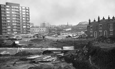
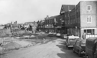
 The picture above shows the
St. Oswald's Way section during the course of construction, together with
the high-rise flats- brand new when the picture was taken- which replaced
older housing in the Newtown area. Delamere Street, seen on the right, formerly joined up with Victoria Road and St. Anne Street (just out of shot on the left) until St. Oswald's Way was driven between them.
The picture above shows the
St. Oswald's Way section during the course of construction, together with
the high-rise flats- brand new when the picture was taken- which replaced
older housing in the Newtown area. Delamere Street, seen on the right, formerly joined up with Victoria Road and St. Anne Street (just out of shot on the left) until St. Oswald's Way was driven between them.
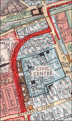
Right: a detail from the 1944 Greenwood Plan for a new Chester relief road, showing how the road would curve round to meet Northgate Street, obliterating King Street in the process, and exit the City Walls via a new, enlarged Northgate. Instead, the Inner Ring Road continued straight on and passed through the walls via the new St. Martin's Gate to the St. Martin's Way flyover.
The cleared area in the centre distance has long been known by the curious
name of Gorse Stacks, owing to part of it at one
time being utilised for the safe storage outside the city walls
of brushwood and suchlike fuel for baker's ovens- a safety measure introduced nationally after the terrible destruction brought about by the Great Fire of London.
Once the centre of a
thriving commercial district centred upon the Cattle Market, which
was demolished in the 1960s to make way for a traffic island on the new
Ring Road, it has long been generally accepted to be in urgent need of
improvement- thirty years on it, remarkably, remains a scruffy area devoted to the
parking of cars.
Major reports in 1964 and 1968 recommended the area be redeveloped and
the building of a hotel here was proposed, but not acted upon, at the
end of the 1980s. Then, in 1995, it was proposed to enclose the entire
area within a new 'Millennium Wall', within which would be created a landscaped
'cultural quarter' containing galleries, shops, restaurants and the like-
plus a new public square and open air market. Some of the 'science fiction-style' artist's impressions of the time (left) gave
rise to considerable local criticism- and no little hilarity.
 Moreover,
it was estimated that the project would cost an astonishing £118 million, much of which was expected to come from the private sector
and local authorities, but over £60 million was applied for from
the Millennium Commission- unsuccessfully, as it turned out.
Moreover,
it was estimated that the project would cost an astonishing £118 million, much of which was expected to come from the private sector
and local authorities, but over £60 million was applied for from
the Millennium Commission- unsuccessfully, as it turned out.
Without this crucial funding, the entire ill-planned project foundered and no mention
of it has since been heard- although, independently of this, an excellent organisation
by the name of Chester in Concert has tirelessly campaigned for
the erection of a purpose-built concert hall, exhibition and arts centre
on Gorse Stacks. Interestingly, town planner Greenwood had proposed the building of a dignified Civic Centre and concert hall behind the Town Hall back in the 1940s- another of his fine ideas never acted upon.
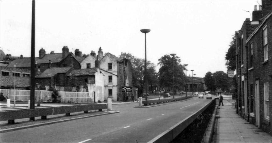
Moving on a few yards, here is the continuation of St. Oswald's Way just past the junction with Hoole Way. The road rises to meet the bridge that carries it over the Shropshire Union Canal.
The main road to the suburb of Hoole- where these words are being written- the road to Warrington and also the General Railway Station, was formerly Brook Street, just out of shot on the left. This too, was curtailed by the Ring Road and for a long time, was linked to the city merely by an unpleasant pedestrian underpass, thankully removed a few years back and replaced by a pelical crossing. Nontheless, Brook Street, once the well-to-do main approach to the city from the railway station, is much reduced in status and sadly shares little in the affluence of the nearby city centre.
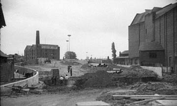 The large building on the right started life as a grand cinema, the Gaumont Palace, but today hosts a lively bingo club. The tall chimney in the background belongs to what was then the Griffiths Brother's mill, "Provender Millers and Merchants", which was later restored and converted into what is today the excellent Mill Hotel.
(You can see some more photographs of it around this time as viewed from the Shropshire Union Canal here).
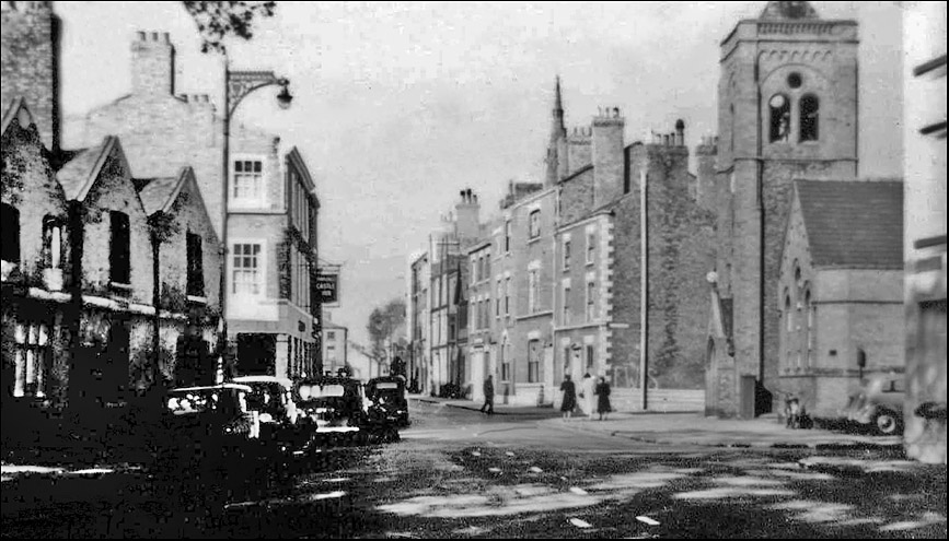
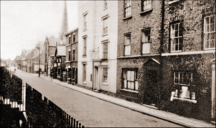
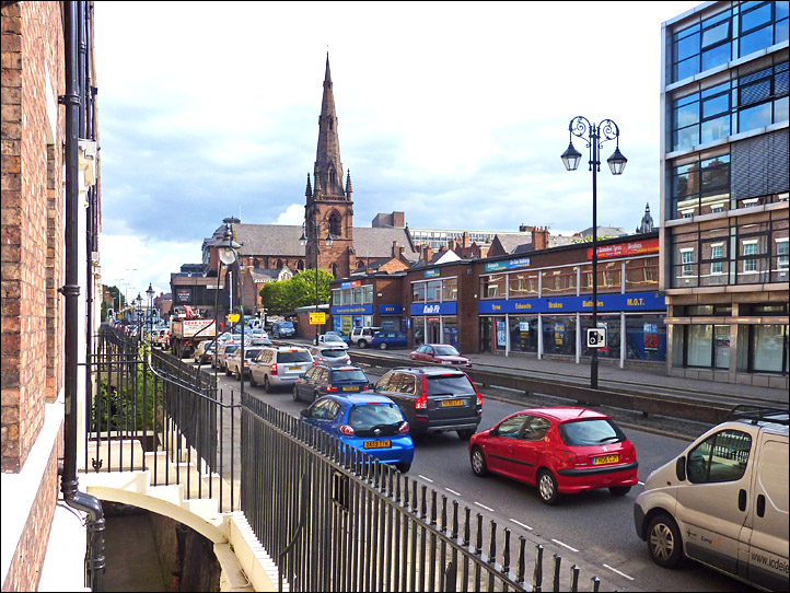
Illustrated below is what is now known as Brookdale Place, but was then the end of Brook Street, photographed from Cow Lane Bridge, which crosses the canal to connect with Frodsham Street and the city centre- the exact route of the old Roman road to Warrington. On the right is Union Terrace, which runs alongside the canal in the direction of the Chester Leadworks.
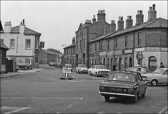
On the left was once the site of the Cattle Market. For centuries, livestock were driven in from the surrounding countryside to be sold here, but when this photograph was taken, the entire area had been recently flattened to make way for the widening of the road leading from a rebuilt Cow Lane Bridge, for car parking and for a traffic island at the junction of St. Oswald's Way and Hoole Way.
 Reader Valerie Sheckler, now resident in Florida USA, wrote to us: "I spent many hours playing at the Cattle Market on George Street, hoping that a sheep or pig would escape as the farmers loaded and unloaded them. It was hilarious to watch grown men chasing a squealing pig down the road with kids in tow!"
Writing in the local press in 1999, Mrs J Moore recalled, "I've been reminiscing about the days of my youth when cows and sheep grazed on the middle of the big Roodee when the grass was higher than me. It was cows in summer and sheep in winter. I can't remember when they started to cut the grass by machine- some time after the war, I think.
I recall cows coming up and down Lower Bridge Street on their way to the Cattle Market at Gorse Stacks. Tuesdays and Thursdays were days when, if you had any sense, you kept away from the Cow Lane Bridge and Brook Street area unless you were at ease with cows, bulls, sheep, pigs etc. The cows were the worst (unless the occasional bull escaped) They went into shops, and so did the public trying to dodge them- hopefully not the same shops! My sister worked in Brook Street and remembered many a heart-stopping occasion. At least, she said, in Brook Street you could avoid them, but if you met the herds on Cow Lane Bridge, there was nowhere to hide!"
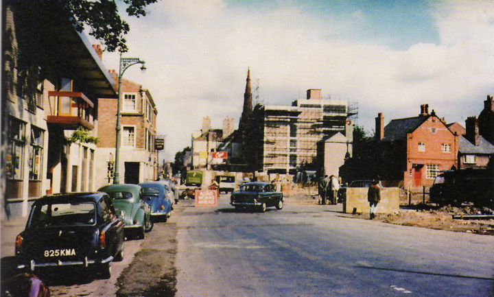
You can see the route of the new road marked out with white stakes.
At this time however, Brook Street started at this point and met Hoole Road at the bridge crossing the railway near the General Station. Today, Brook Street is much shorter, commencing at the 'black-and-white' pub in the distance and all the buildings to its right have vanished to make way for the Ring Road.
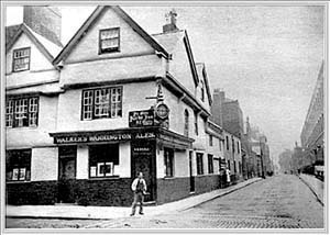 Here is a fine 19th century photograph of the historic Yacht Inn, which for centuries stood on the corner of Watergate Street and Nicolas Street. This was where the Dean of Dublin Cathedral- and, more famously, the author of Gulliver's Travels- Jonathan Swift, after having been 'stood up' for a dinner date with local churchmen, reputedly scrawled with his diamond ring on one of the inn's windows,
"Rotten without and mould'ring within, this place and its clergy are all near akin."
The venerable Yacht, together with every other building on the left hand side of the photograph, was destroyed when Nicolas Street was doubled in width and their cellars now lie buried beneath the modern Ring Road. This side of the modern street now boasts a motley collection of mediocre modern structures including a multi-storey car park, tyre depot and office buildings.
(More of the immortal Swift's less-than-complementary rhymes about Chester and its people may be enjoyed here...)
Commercial considerations were paramount and the car was king. Heritage- all that made Chester unique- took very much second place when there was money to be made. This was drastically illustrated when a vast and miraculously well preserved Roman bath house complex, "with walls up to two hundred feet long, standing to twelve feet in height" was destroyed to make way for an underground car park beneath the ghastly Grosvenor Laing Shopping Precinct which was being developed at around the same time as the Ring Road.
All of these geographical details may make more sense when you view this aerial photograph of the area, dating from around the same time or this interesting 1950s map of Chester showing how the city looked just before the new road was built.
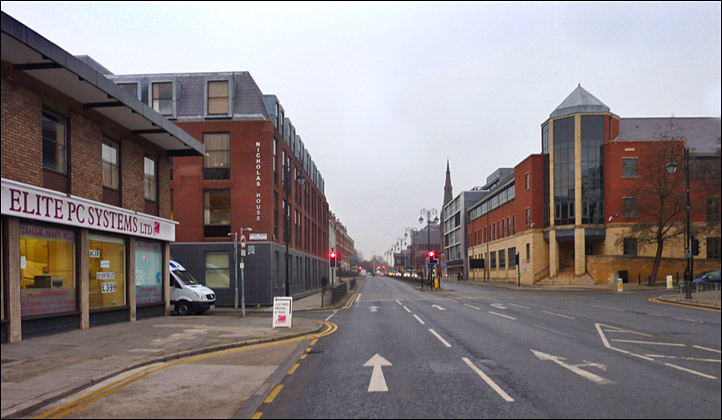
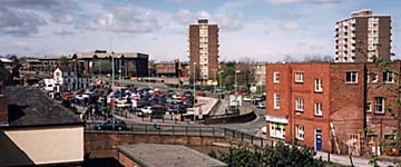 Finally, illustrated here is the same area today, looking across Cow Lane Bridge towards St. Anne Street from the top of the Tesco supermarket car park. The red brick building on the corner of Union Terrace- seen in the photograph above- still stands and is now a ceramic tile retailer.
The Inner Ring Road curves around the site of the former Cattle Market- now a car park- and past the fire station on the corner of St. Anne Street and the bulk of the Northgate Arena, which houses Chester's swimming baths and sports facilities. Before the coming of the Inner Ring Road, the Northgate Railway Station stood on this site.
Here is a photograph by Chris Langford of the building of the Ring Road near Cuppin Street and here is an aerial photograph of the construction of the St. Martin's Way flyover.