|
  pproaching
the
end
of
Nun's
Road on
the
western
section
of
Chester's
city
walls,
we
see
below
us
the
numerous
and
complex
rooftops
of
the
various
buildings
connected
with
the
Racecourse
on
the Roodee. pproaching
the
end
of
Nun's
Road on
the
western
section
of
Chester's
city
walls,
we
see
below
us
the
numerous
and
complex
rooftops
of
the
various
buildings
connected
with
the
Racecourse
on
the Roodee.
The
road
before
us
dips
down
sharply
to
the
traffic
lights
and
busy
junction
with Watergate
Street (take
care
here)-
but
the
wall
rises
slightly
to
lead
us
on
to
the Watergate.
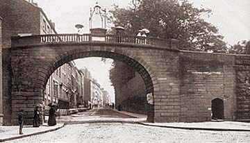
On
the
right
we
see
the
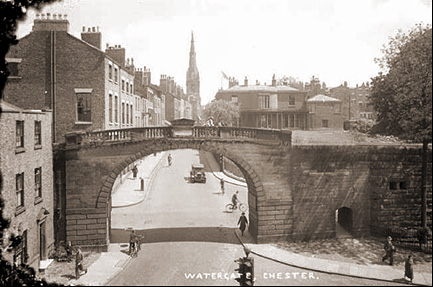
gate
as
it
appeared
in
1888,
in
one
Francis
Frith's
fine
views, and below in a postcard from 1940.
Except
that
the
fancy gas
lamp
atop
the
gate
in the earlier picture has
been
removed-
and
an
inevitable
huge increase
in
traffic-
this
scene
is
little
changed
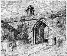
today. Compare it with the conjectural artist's impression of how the original Watergate looked, below..
As
with
the
city
gates
previously
visited
on
our
walk,
this
is
another
example
of
an
18th
century
arch
built
to
replace
a fortified
medieval
gateway.
At
the
time
of
its
purchase
by
the
corporation
from
the
Earl
of
Derby
in
1788,
it
was
considered
so "dangerously
ruinous" that
it
had
to
be
immediately
demolished
and
the
present
arch,
designed
by Joseph
Turner,
was
erected
the
following
year.
Turner
also
designed
the Bridgegate and
the
elegant
row
of
houses
in
Nicolas
Street, known, because of the number of doctors who lived and practised there,
as 'Pill-Box
Terrace'-
which
we
will
visit
shortly. His home was in nearby Paradise Row, of which more below...
 On
the
western
front
of
the
Watergate
may be seen
the following
inscription: On
the
western
front
of
the
Watergate
may be seen
the following
inscription:
IN
THE
XXIX.
YEAR
OF
THE
REIGN
OF
GEO.
III
IN
THE
MAYORALITY
OF
JOHN
HALLWOOD
AND
JOHN
LEIGH,
ESQUIRES,
THIS
GATE
WAS
ERECTED-
THOMAS
COTGREAVE,
EDWARD
BURROWS,
ESQUIRES,
MURENGERS.
The Watergate was closely guarded until well into the 18th century, and had been ably protected
by a heavy double door, portcullis and drawbridge.
Tolls were levied on all
goods entering the town, not just here but at all of the city's gates, a portion of which were taken as murage, a tax to fund the maintainance of the defences, carried but by an order of masons by the name of the Murengers. What remained went into the ample pockets of the noble families who paid huge sums to the King for the right to collect the dues. Due to its proximity to the busy harbour, the Sergeancy of the Watergate had long
been regarded as a coveted and lucrative position and was held by the Stanleys,
Earls of Derby, whose fine, black & white timber town house, Stanley Palace (1591)
still stands, a little way up the hill, on the right hand side of Watergate Street.
Their employee, the Keeper of the Watergate, to quote the ancient records, "takes of every cart entering with firewood: one branch; of every horseload
of fish: five fishes; of every boat coming to the aforesaid gate with large
fish or salt salmon: one fish; with herring, fifty".
 In 1615, referring to the status of the Watergate and its neighbourhood, it
was said "which gate is less than any of the other three, serving only for
the passage to the rood-eye and to the banks of the river, where are brought
into the city all such commodities of coal, fish, corn and other things; which
barks and other small vessels bring up so far upon the waters of Dee". In 1615, referring to the status of the Watergate and its neighbourhood, it
was said "which gate is less than any of the other three, serving only for
the passage to the rood-eye and to the banks of the river, where are brought
into the city all such commodities of coal, fish, corn and other things; which
barks and other small vessels bring up so far upon the waters of Dee".
We regret to say that visitors walking our City Walls today will observe that the Watergate is rather a sorry sight. It remains passable but is covered in scaffolding and has, remarkably, remained in this condition since as long ago as September 2012. Remedial work had been carried out a few years before this but evidently proved to be less than satisfactory and the current distressing situation is the result. It remains a mystery to caring locals as to why there has been such a long delay in carrying out the necessary repairs; responsibility for maintaining Chester's historic infrastructure falls to Cheshire West and Chester Council, advised by English Heritage, but they say there is no money to address the problems, not just here but also at the Northgate, Abbey Green and the City Walls adjoining the Groves among others. Meanwhile, half a million pounds has been found to restore Chester's best known entrance, the Eastgate and its famous clock- for the third time in the last quarter century. Watch this space for news of future improvements..
Beyond the Watergate
Looking
out
here
from
the
City Walls,
beyond
the
nearby Watergate
Inn and
main
entrance
to Chester
Racecourse,
the
modern view
of
busy New
Crane
Street,
with
a large
car
park
to
its
right, is
fairly
uninspiring.
Consider, however, that where we stand was for centuries
the
main
gateway
to
the
wharves
and
quays
of
the largest, most important seaport in the region and
ancient
Watergate
Street
once
its
'dock
road'.
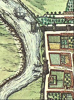 16th
and
17th
century maps, such as that by Braun here (see the whole of his impressive 1571 map of the city, and many more, here) - show
the
River
Dee
approaching
right up
to
the
Watergate,
allowing
just
enough
room
for
a quay
where
goods
were
loaded
and
unloaded
to and from
waiting
ships
and
from where heavily laden carts and trains of pack horses laboured up the hill, carrying the goods via the Customs House to the safety of the merchant's houses in the town. 16th
and
17th
century maps, such as that by Braun here (see the whole of his impressive 1571 map of the city, and many more, here) - show
the
River
Dee
approaching
right up
to
the
Watergate,
allowing
just
enough
room
for
a quay
where
goods
were
loaded
and
unloaded
to and from
waiting
ships
and
from where heavily laden carts and trains of pack horses laboured up the hill, carrying the goods via the Customs House to the safety of the merchant's houses in the town.
Later,
as
the
River
Dee silted
and
receded and, followed the canalization of the lower river in the first half of the eighteenth century, new quays
and
shipyards
were
established along the newly aligned riverbank standing further out from the Watergate in the area we still call today 'The Old Port'.
In accordance with the scheme of development the site of the old wharf immediately outside the Water Gate was levelled, and an open space, then and now called Watergate Square, was formed. From this point three new roads, Paradise Row, Middle Crane Street, and New Crane Street, were laid out to give access to various parts of the riverside. Subsequently, one or two minor cross streets and a number of courts came into being. All of these streets were constructed after 1745, when the only way between the Water Gate and the wharves was an indirect track alongside and across an extensive timber yard that then occupied much of the later residential area. This track started at the Watergate and, after following a part of the course of what is now New Crane Street, passed through the middle of the timber yard and reached the Old Crane along the lower end of what became Middle Crane Street.
The houses that soon arose along these new thoroughfares were, doubtlessly in the first instance inhabited by people specially interested in the new port and its facilities, such as merchants, shipbuilders, mariners, customs officials, etc. As time went on and the temporary prosperity of the port declined, most of the original tenants gradually drifted away and their places were taken by others unconnected with the maritime affairs of Chester. These later inhabitants considered the area to be a convenient and not undesirable place of residence, and those who selected Paradise Row would appreciate the attractive outlook over the Roodee. It was described as "a
street
of
genteel
houses" according
to
the
1792
directory. Near here also existed in the eighteenth century a building known as 'The Pentice on the Roodee' at which, presumably, the business of the Corporation in connection with the port was dealt with.
 The author of an anonymous work, A Walk Round the Walls and City of Chester, published around 1800, has this to say regarding the area, "On the north east side (of the Roodee) is Paradise Row, a street built within these few years; beyond that, Crane-street. By an ancient map, in the Editor's possession, the deepest part of the river, two centuries back, was formed in the centre of these streets and the channel flowed to the entrance of the Gate-way". The author of an anonymous work, A Walk Round the Walls and City of Chester, published around 1800, has this to say regarding the area, "On the north east side (of the Roodee) is Paradise Row, a street built within these few years; beyond that, Crane-street. By an ancient map, in the Editor's possession, the deepest part of the river, two centuries back, was formed in the centre of these streets and the channel flowed to the entrance of the Gate-way".
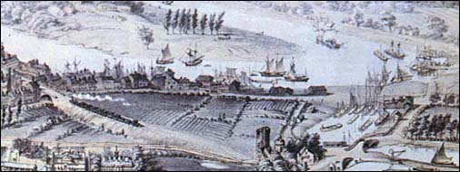
This aerial
view-
a
detail
from
John
McGahey's
famous View
of
Chester
from
a
Balloon- shows
the Old
Port and
its
surroundings
as
they
appeared
in 1855.
Despite the canalisation of the River Dee years earlier, it continued to silt up and the boom years of the commercial port were not to last. J. H. Hanshall, the second Editor of the Chester Chronicle (first published in 1775 and still around today), wrote, “As the years go by it is clear from the newspaper and other records that the trade of the Port of Chester is drifting desultorily but inexorably into the silting sand. But if the bigger ships of the day can no longer reach her, the history of former times repeating itself, the old Port can at least build ships for others".
He described the area as he saw it around 1816: "Beyond the Watergate are Crane-street, Back Crane-street, and Paradise Row, the whole of which lead to the wharfs on the river. For a number of years Chester has carried on a considerable business in shipbuilding. Within the last ten years the trade has wonderfully increased, and even now it is not unusual to see ten or a dozen vessels on the stocks at a time. In fact, there are nearly as many ships built in Chester as in Liverpool, and the former have always a decided preference from the merchants. Indeed, Chester lies particularly convenient for the trade, as by the approximation of the Dee, timber is every season floated down from the almost exhaustless woods of Wales, at a trifling expense and without the least risk. The principal shipwright in Chester is Mr. Cortney, but Mr. Troughton’s is the oldest establishment. There were lately nearly 250 hands employed in the business, two-thirds of whom were in Mr. Cortney's yard, but the trade is at present flat. Six vessels of war have been built by him, and within the last two years (1814-15) two corvettes and two sloops of war, The Cyrus, The Mersey, The Eden, and The Levant, from twenty to thirty guns each. The firm of Mulvey and Co., formerly of Frodsham, have established a yard near the Crane. Cortney's yard launched a brig in 1804, an East lndiaman of 580 tons in 1810, and in 1813 a West India-man of 800 tons, in addition to the corvettes and war sloops mentioned by Hanshall.”
 Writing in The Cheshire Sheaf, one ‘J.H.E.B’ described the area as he knew it in June 1945, “Middle Crane Street. This street, originally known as Crane Street and later as Old Crane Street, was the first of the roads to be laid out. its course is in a direct line from the Watergate to the Old Crane, and its construction necessitated the removal of the large timber yard to a site immediately under the Walls to the north of the Watergate. It appears to have been constructed shortly after 1750 and certainly before 1782. A glance at the houses of Middle Crane Street indicates that those at the upper end, at least, were intended for occupation by people of some stability, and that they were built towards the close of the eighteenth century. Some of the houses on the south side of the street have gardens in the rear that extend as far as Paradise Row and thus afford an excellent view of the Races and other events held on the Roodee. Writing in The Cheshire Sheaf, one ‘J.H.E.B’ described the area as he knew it in June 1945, “Middle Crane Street. This street, originally known as Crane Street and later as Old Crane Street, was the first of the roads to be laid out. its course is in a direct line from the Watergate to the Old Crane, and its construction necessitated the removal of the large timber yard to a site immediately under the Walls to the north of the Watergate. It appears to have been constructed shortly after 1750 and certainly before 1782. A glance at the houses of Middle Crane Street indicates that those at the upper end, at least, were intended for occupation by people of some stability, and that they were built towards the close of the eighteenth century. Some of the houses on the south side of the street have gardens in the rear that extend as far as Paradise Row and thus afford an excellent view of the Races and other events held on the Roodee.
 Paradise Row appears to have been constructed shortly after Middle Crane Street. It was in existence in 1782 and it provided a more direct access to the considerable works that stood on the site now occupied by the Gas Company. Paradise Row, flanked by its neat looking houses and lengths of garden walls, is a quiet highway except at the times of the annual races. Most of its present vehicular traffic is bound to or from the Gas Works, but in its early years it served timber yards, iron works, and part of the shipyards, as well as the Old Workhouse. Paradise Row appears to have been constructed shortly after Middle Crane Street. It was in existence in 1782 and it provided a more direct access to the considerable works that stood on the site now occupied by the Gas Company. Paradise Row, flanked by its neat looking houses and lengths of garden walls, is a quiet highway except at the times of the annual races. Most of its present vehicular traffic is bound to or from the Gas Works, but in its early years it served timber yards, iron works, and part of the shipyards, as well as the Old Workhouse.
It has had some notable residents, such as Joseph Turner, the architect who designed the Bridgegate and a number of other buildings in Cheshire, Denbighshire and Flintshire.
New Crane Street was made between 1782 and 1795 and as the name suggests, it provided direct access to the later but more enduring New Crane. With one or two exceptions the older buildings along its course are of a humbler character than those in the other streets.”
Earlier, Chester author and guide Joseph
Hemingway,
writing
in
1836,
stated
that "the
river
here is
navigable
for
ships
of
350
tons
burthen.
From
the
quays
are
exported
some
of
the
richest
cargoes
of
that
excellent
commodity
which
affords
to
the
taste
of
the
Londoners
the
most
grateful
flavour,
and
presents
the
Cockney
with
what
he
calls
"The
fattest
Velsh
rabbits
in
the
Vorld"-
good
old Cheshire
Cheese.."
To
the
left,
between
here
and
the
Roodee,
stood
150
years
ago
the previously-mentioned workhouse or House
of
Industry asit was called at the time.
Hemingway
again: "That
asylum
for
age
and
indigence,
whose
inmates
are
provided
with
all
necessities
of
food
and
clothing;
it
is
regularly
visited
by
a clergyman
and
a medical
man,
and
contains
a school
and
an
establishment
for
insane
paupers".
 The author of A Walk Round the Walls and City of Chester wrote of it in 1800, "on the west side of the Rood-eye stands the general Work-house, or House of Industry, where the poor of the several parishes are employed, and provided for in a proper manner. It is a commodious building and contains generally two hundred persons. It receives the poor from distant parishes, by agreement between the governor and parish officers." The author of A Walk Round the Walls and City of Chester wrote of it in 1800, "on the west side of the Rood-eye stands the general Work-house, or House of Industry, where the poor of the several parishes are employed, and provided for in a proper manner. It is a commodious building and contains generally two hundred persons. It receives the poor from distant parishes, by agreement between the governor and parish officers."
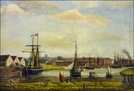
This
area,
today
known
as 'The Old
Port' (illustrated left as it was in the 19th century) a few years ago underwent
a major
redevelopment.
New
houses, apartments, young
people's
accomodation and other valuable facilities
were
built,
but
a plan
to
demolish
the
historic
Victorian Electric
Light
Building led
to
a spirited, two-year
campaign
of
opposition
from
local
people-
which
resulted
in
at
least
the
facade
of
this important
building
being
saved
and
incorporated
within
the
new
development. Read more about it in our chapters devoted to the Old Port area here.
Within
the
City
Wall, Watergate
Street rises
steeply
to
where
the
spire
of Holy
Trinity
Church-
also
known
as
The Guildhall-
stands,
near
to
which
was
the
West
Gate
of
the
Roman
Fortress-
the Porta
Principalis
Dextra-
and
from
that
point
lies
the
line
of
the Via
Principalis,
the
present-day
Watergate
and
Eastgate
Streets.
Could
the
Saxon
founders
of
Holy
Trinity
have
ulitised
a
ruined
gatehouse
connected
with
the
West
Gate
for
their
first
church?
A
very
similar
situation
existed
in
what
is
now
the
middle
of
the
busy
junction
of
Bridge
Street
and Grosvenor
Street,
where
for
centuries
there
stood
a
church
dedicated
to St. Bridget,
which
was
founded
around
the
year
797
by
King
Offa
on
the
site
of
the
vanished
Roman
Southgate,
or Porta
Praetoria.
Another ancient church once existed in this part of Chester, one dedicated to St. Chad. One source stated that the church, "stood in the croft over against the Black Friars on the north side of Watergate Street near to the Watergate". A document of 1388 makes mention of a garden situated close to it, but other than that, we have virtually no further information about the church, or of when and why it disappeared. Its approximate site is today occupied by The Queen's School, which we will visit a little later in our walk around Chester's walls.
The Grey Friars
 All of the land bounded by today's Watergate Street, Bedward Row (which we will pass just before we reach the Infirmary), St. Martin's Way (the Inner Ring Road) and the City Walls once formed the precinct of the Franciscan Friars- the Grey Friars. We learned a little of their neighbours, the Dominicans or Black Friars and the nuns of St. Mary's in our previous chapter. All of the land bounded by today's Watergate Street, Bedward Row (which we will pass just before we reach the Infirmary), St. Martin's Way (the Inner Ring Road) and the City Walls once formed the precinct of the Franciscan Friars- the Grey Friars. We learned a little of their neighbours, the Dominicans or Black Friars and the nuns of St. Mary's in our previous chapter.
The friary was founded in 1237-8, only a year or so after the Dominicans- who actually opposed their foundation on the grounds that they feared there would not be enough alms forthcoming in the small town to support both institutions.
Having overcome these early difficulties, for the three centuries of their existence the friars seem to have gone about their business uneventfully and history tells us little of them. The Franciscans were always the smallest and poorest of the religious foundations in Chester and indeed, by 1529, they had become so impoverished that they were compelled to let out the nave and three aisles of their church to the merchants and sailors of Chester, as a place for storing and repairing sails and other things requisite for their ships, on the understanding that the merchants undertook all necessary repairs to the church.
Together with the other two Chester religious houses on this side of the city, the unfortunate Franciscans finally surrendered their house to Henry VIII's commissioners on 15th August 1538 after which time the estate passed through the hands of several owners including, in 1588, the Warburtons. They sold it to the Stanleys,
Earls of Derby, in 1622 who retained the lands until 1775 when they were purchased by the Linen Merchants, who erected their new Linen Hall on part of the site and sold the rest for residential development. On this western half of the site arose during the 1770s Watergate Flags (the area immediately outside the Watergate), Stanley Place and Stanley Street. At the time of the sale the entire area was known as the Grey Friar's Close or, alternatively, as the Yacht Field. We will discuss this area further in our next chapter...
The friary buildings, remarkably, survived right through from the Dissolution until this final splitting up of the lands for development and the tall steeple of their church long served as a guide to mariners entering the Port of Chester, and is marked on contemporary charts as such, before falling into private hands and finally being demolished. The antiquarian William Webb wrote of its removal, "It was a great pitie that the steeple was put away, being a great ornament to the citie. This curious spire steeple might still have stood for grace to the citie had not private benefit, the devourer of antiquitie, pulled it down with the church, and erected a house which since hath been of little use, so that the citie lost so good an ornament, that tymes hereafter may talk of it, being the only seamark for direction over the bar of Chester".
Our city, it seems, has suffered from the destructive ways of the property developer for longer than we realised.
Aside from the nuns of St. Mary's, the Blackfriars and Greyfriars, whose houses all were situated on this side of the city, and the Benedictine monks of the great Abbey of St. Werburgh (now the Cathedral), there was yet another religious community in Chester- that of the Carmelite White Friars. Their monastery and lands were situated on the other side of Nicolas Street, the modern Inner Ring Road and the narrow street called White Friars (formerly White Friars Lane) perpetuates their name to this day. The monks acquired further parcels of land as time went by and their estate in its final form was bounded by Commonhall Street to the north, White Friars to the south, Bridge Street to the east and Weaver Street to the west.
Left: The view from the Watergate along Nun's Road with the Roodee and buildings of Chester Racecourse on the right. The former Greyfriars' lands are on the left.
Their community had existed in Chester since around 1277 but it was only in 1290 that one Hugh Payn granted
them land "in a suburb of Chester" on which to build their house. That this area, now very much in the heart of the city, was referred to as a 'suburb' indicates how undeveloped great areas within the Walls long remained and, indeed, this area did not finally become fully built-up until the late 15th century.
As with the other religious houses, the Carmelite's church was rebuilt and enlarged several times over the two and a half centuries of occupation and in 1495 the tower was rebuilt and furnished with a tall and graceful steeple.
 When the Dissolution came in 1538, as with the other religious houses (except, of course, for the Abbey), the monks were dispossessed and the buildings and land passed through the hands of several owners, including the Duttons and Gamuls, who probably made their substantial mansion from the monk's former domestic quarters and buildings of the outer court. The large and impressive church, however, long remained in use- it may be seen on Braun's 1571 map of Chester- and became the burial place of several prominent local families. But, in 1592, it was sold to Thomas Egerton, the Attorney-General, who proceeded to tear down the church and spire, and possibly the other buildings as well, and built his mansion on the site. This in turn disappeared and was replaced by the large private house, 'The Friars', which remains, standing in its extensive grounds, with us today. When the Dissolution came in 1538, as with the other religious houses (except, of course, for the Abbey), the monks were dispossessed and the buildings and land passed through the hands of several owners, including the Duttons and Gamuls, who probably made their substantial mansion from the monk's former domestic quarters and buildings of the outer court. The large and impressive church, however, long remained in use- it may be seen on Braun's 1571 map of Chester- and became the burial place of several prominent local families. But, in 1592, it was sold to Thomas Egerton, the Attorney-General, who proceeded to tear down the church and spire, and possibly the other buildings as well, and built his mansion on the site. This in turn disappeared and was replaced by the large private house, 'The Friars', which remains, standing in its extensive grounds, with us today.
Of more recent times, the site of the old Greyfriar's monastery was occupied by a complex of utilitarian Government offices by the name of Norroy House. After these were vacated, they were extensively restored and enlarged to house a brand new hotel which opened for business in April 2015.
Back in Watergate Street, this
19th
century
engraving
shows
the ancient Yacht
Inn (named after the Yacht Field upon which it was built) and
the
view
up
Watergate
Street
towards
the
centre
of
the
city
and
The Cross. On
the
left, Holy
Trinity
Church is
yet
to
be
rebuilt
and
acquire
the
tall
spire
we
see
today-
which
work
was
carried
out
in
1865-9
by
James
Harrison.
 As
we
stand
atop
the
Watergate,
the
late
18th
century
houses
nearest
to
us
on
the
north
side
of
the
street
occupy
the
site
of
the
legionary
bath
houses
which
were
situated
here
outside
the
fortress
to
minimise
fire
risk
and
be
nearer
to
the
water
source. As
we
stand
atop
the
Watergate,
the
late
18th
century
houses
nearest
to
us
on
the
north
side
of
the
street
occupy
the
site
of
the
legionary
bath
houses
which
were
situated
here
outside
the
fortress
to
minimise
fire
risk
and
be
nearer
to
the
water
source.
That
side
of
the
nearby
corner
house
which
runs
parallel
with
the
wall
still
has
as
its
foundation
part
of
the
west
wall
of
the
ancient
bath
house,
which
is
pierced
by
the
furnace
arch
of
a hypocaust.
Also
found
on
the
site
were
the
remains
of
a sudatory (sweating
bath)
and
many
tiles
stamped
with
the
wild
boar
motif
of
the
XXth
Legion,
considerable
amounts
of
coins
of
the
reigns
of
Hadrian
and
Trajan
and-
most
importantly-
a carved
altar, dedicated to 'Fortune the Home-bringer, to Aesculapius and to Salus'. One of the sculptures on the side of the altar is a staff entwined with a snake, the distinctive symbol of Aesculapius who was the greatest Greek and Roman healing god (a similar motif is still used today in medicine). Salus was the goddess of health. Another carving on the side is a rudder, symbol of life's course, which was set by the goddess Fortuna.
The altar was set up by the freedmen and slaves in the household of a Roman officer, perhaps because he was ill. This man, the extravagantly-named Titus Pomponius Mamilianus Rufus Antistianus Funisulanus Vettonianus, was the Legatus (Commander) of the 20th Legion at Chester, probably around the year AD 100. His unusually long name is similar to that of a friend of the younger Pliny, and they may be one and the same man, or near relatives..
Due to the lack of a suitable local exhibition place, the
altar
ended up
200
miles
away
in
the British
Museum in
London, where it remains on show today.
Such was the casual attitude to antiquities at the time that one Philip Egerton had a large number of hypocaust pillars and Roman tiles from the site taken to his country mansion at Oulton Park (now a famous motor racing venue) near the Cheshire village of Little Budworth, where they were formed into the floor of a mock 'Druid's Temple' he was having built on the estate.
Som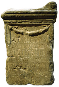 e of the pilae didn't make it as far as Egerton's home and ended up instead in the surrounds of Oakmere Lake. Tragically,
all
other
traces
of
the
extensive
remains
found
on
the
site
were
swept
away- "destroyed
by
the
rude
hand
of
ignorance"-
when
the
present houses
were
built
in
1799.
The
corner
one,
as
we
shall
learn
later,
in
1878
became
the
original
home
of
the Queen's
School
for
Girls. e of the pilae didn't make it as far as Egerton's home and ended up instead in the surrounds of Oakmere Lake. Tragically,
all
other
traces
of
the
extensive
remains
found
on
the
site
were
swept
away- "destroyed
by
the
rude
hand
of
ignorance"-
when
the
present houses
were
built
in
1799.
The
corner
one,
as
we
shall
learn
later,
in
1878
became
the
original
home
of
the Queen's
School
for
Girls.
That
'rude
hand
of
ignorance'
is
a
phenomenon
by
no
means
restricted
to
times
long
gone.
An
even
larger,
and
far
better
preserved,
Legionary
bath
house- "Extending
for
almost
200
feet
with
walls
standing
up
to
12
feet
or
more
in
height"-
found
during
the
construction
of
the Grosvenor
Precinct was
swept
away
for
the
construction
of
underground
delivery
bays,
a
mere
thirty
years
ago.
The
author
recently
photographed
the
well-preserved
remains
of
a
small
Roman
civil
bath
house
in Prestatyn -
a
small
seaside
resort
a
few
miles
along
the
North
Wales
coast,
and
not
otherwise
noted
for
its
antiquities.
Still
clearly
visible
in
situ
are
tiles
stamped
'Leg
XX
VV'
and
bearing
the
wild
boar
motif,
probably
made
at
the
Legionary
works
depot
at Holt on
the
River
Dee.
Shamefully,
Chester,
the
great
fortress
of Deva,
can
boast
of
nothing
like
this
outside
of
sorry
remnants
in
the
glass
cases
of
the
Grosvenor
Museum.
There
was
a
time
when
destruction
came
to
Watergate
Street
in
more
violent
ways. Randle
Holme III wrote
of
the
bursting
of
some grenados (mortars)
here
on
December
10th
1645,
during
the
Civil
War Siege
of
Chester, "Two
houses
in
the
Watergate
Street
skip
joint
from
joint,
and
create
an
earthquake;
the
main
posts
jostle
each
other,
while
the
frightened
casements
fly
for
fear,
in
a
word,
the
whole
fabric
is
a
perfect
chaos,
lively
set
forth
in
the
metamorphosis:
the
grandmother,
mother
and
three
children
are
struck
stocke
dead
and
buried
in
the
ruins
of
their
humble
edifice"...
Read more of Holmes' terse description of the great destruction caused to Chester during those troubled times here- or go on to part II of our exploration of the Watergate area...
Curiosities from Chester's History no. 23
-
1693
A
Roman
altar
found
in Eastgate
Street,
which
had
been
erected
by
Flavius
Longus,
military
Tribune
to
the
20th
Legion
and
his
Son,
Longinus
from
Samosata
in
honour
of
the
Emperors
Diocresian
and
Maximian
"in
discharge
of
a
vow
to
the
Genio
Loci". -
- 1695 The Exchange commenced (completed 1698). The forerunner of today's Town Hall, it stood in the Market Square until it burned down in 1862.
-
1696
New
coinage
in
England
carried
out
by John
Locke and Isaac
Newton (who up the post of Warden of the Royal Mint in this year) .
Chester
selected
as
one
of
six
cities
to
be
allocated
an
Assay
Office-
a
mint
being
this
year
set
up
and
coinage
of
money
(which
bore
a
'C'
under
the
monarch's
head)
began
on
the
2nd
October. Old hammered silver coins were recalled, melted down and re-issued as milled coins. In charge of the Chester mint was
the
great
astronomer Edmund
Halley-
he
of
comet
fame.
In 1697, he
observed
a
rare
triple
rainbow from the Phoenix Tower. -
1699
The Bluecoat
School outside
the Northgate was
founded
by
Bishop
Nicolas
Stratford.
The
'Recorder's
Steps'
by
the
river
were
built
as
a
compliment
to
Roger
Comberbach,
Recorder
of
Chester -
-
- 1702
William
III
died
and Queen
Anne (1665-1714) came
to
the
throne.
The
Quaker's
Meeting
House
in
Cow
Lane
(Frodsham
Street)
built,
and Pemberton's
Parlour was
rebuilt.
- 1704 The City Walls extensively repaired after their pounding during the Civil War and converted to promenades.
|
