| Welcome to our growing gallery of old maps, drawings and aerial photographs of Chester as she was.
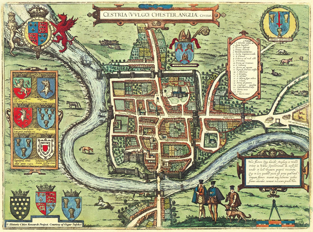
Our first map, above,
appeared
in
G. Braun's Civitates
Orbis
Terrarum of
1572-1618
and
is
a
clear
indication
of
how
Chester
appeared
in
the
middle
of
the
16th
century.
It
shows
a
community
still
living
largely
within
the
ancient
city
walls,
with
suburban
settlements
beyond
the Northgate, the Eastgate, spreading
up Cow
Lanee-
today's
Frodsham
Street-
and
over
the River
Dee in
Handbridge. Note the strong defensive gate on the Handbridge side of the Old Dee Bridge.
Notice
how
the
River
Dee curves
round
and
joins
the
walls
at
the Watergate, where
ships
are
berthed. For centuries, until the disastrous silting of the river, Chester was the largest and busiest seaport in north west England, trading with ports throughout the British Isles, Ireland and Europe. In the eighteenth century, it even sent slave ships to Africa and traded with, and sent emigrants to, the Americas.
The Watertower was built to defend the port in 1322, and the map shows it still standing
surrounded
by
water. Today it stands high and dry, in the middle of a pretty park, the Watertower Gardens.
Following Lower Bridge Street up from the Bridgegate and river, two ancient churches stand facing each other at the junction with Pepper Street. These were St. Michael's on the right- still with us today and now the home of Chester History and Heritage- and St. Bridget's, which was founded in 797 by King Offa of Mercia and demolished and relocated when Grosvenor Street was cut diagonally across the old street plan to meet the new Grosvenor Bridge around 1830. (it can be seen among our views opf the neighbouring Old Lamb Row). For centuries, the area was actually known as "The Two Churches".
This second St. Bridget's, which was rebuilt near the Castle, was in its turn demolished in 1964 to make way for a traffic island on the new Inner Ring Road- upon which some of the gravestones from its churchyard still stand today.
Beyond
the
Eastgate,
on
the
right
of
the
map,
you
can
see
a
secondary
defensive
gate
and
wall,
known
as The
Bars and
beyond
that,
where
the
road
branches,
is
Barrel
Well
Hill,
at
this
time
known
as Gallows
Hill in
the
suburb
of Boughton-
the
town's
chief
place
of
execution-
Chester's
Tyburn-
where
was
situated
the
gallows
and
the
stake,
for
burnings...
 Inside
the
entire
length
of
the
west
wall
are
the
former
houses, fields
and
gardens
of
the monastic communities, the Greyfriars, Whitefriars and
the nuns of St.
Mary, all of which, together with the Blackfriars and the great Abbey of St. Werburgh, had
been
dissolved
thirty
years
earlier. St. Werburgh's was transformed into Chester Cathedral but all of the others were sold off and redeveloped for other purposes and not a trace of them remains above ground today. Inside
the
entire
length
of
the
west
wall
are
the
former
houses, fields
and
gardens
of
the monastic communities, the Greyfriars, Whitefriars and
the nuns of St.
Mary, all of which, together with the Blackfriars and the great Abbey of St. Werburgh, had
been
dissolved
thirty
years
earlier. St. Werburgh's was transformed into Chester Cathedral but all of the others were sold off and redeveloped for other purposes and not a trace of them remains above ground today.
Much, however,
remains
familiar,
and
a
modern
citizen,
whisked
back
to
the
Chester
of
the
1500s,
would
probably
be able to find
their
way
about
without
too
much
difficulty-
there
are
the
Walls
and
Gates,
the Cathedral, Castle, Old
Dee
Bridge, St.
John's
Church, the Market
Square and
all
of
the
major
and
most
of
the
minor
streets,
situated
just
as
today.
Two
great
changes
in
the
street
plan
have,
however,
occured
since
that
time:
the
previously-mentioned building
of
the Grosvenor
Bridge and
Grosvenor
Street
in
the
1830s
and
the Inner
Ringroad of
the
1960s.
Today's
Cestrian
would
envy
the
fields
full
of
grazing
cattle and sheep
that
surrounded
the
little
town,
but
fortunately
the Roodee, Deanery
Field and Meadows (where
the fashionably-dressed gents and their dog are standing in the foreground)
remain
today
as
open
ground. After four and a half centuries, horses still run around the Roodee and cattle
contunue to
graze on the meadows...
The following description of Braun’s map was written by T. N. Brushfield, M.D. and published in the July 1879 edition of The Cheshire Sheaf...
“One of the most interesting, as it is perhaps the most ancient of the engraved Plans of Chester is the one that appeared in Braun's Vivitates orbis terrarutn, published at Cologne (“Coloniae Agrippinae”) in 6 vols. folio, between the years 1523 and 1618.
The Plan is No. 3 in vol. iii., and measures 14 in. by 13 in. It is headed “Cestria vulgo Chester Angliae civitas,” and bears along its upper and its left hand borders the Royal, Episcopal, and Civic Arms, together with those of the Earls of Chester. The date of this volume is 1616, that of the preceding being 1575. We may fairly assume the plan to represent the City as it was during the closing years of Elizabeth's reign, the latter part of the 16th Century- this is to some extent corroborated by the costume of certain figures depicted on the lower part of the engraving.
The Plan is a bird's eye view of the City, as it would have appeared from the south side. The river channel (lettered “Dea fl. vulgo Dee") is shown to flow close up to the Water gate ("Porta ad aquam"), on either side of which several boats and small ships are moored; it then runs parallel and close to the Wall as far as the Water Tower ("Turris noua"), which is surrounded by water, some portion of which runs through two large arches in the masonry connecting this Tower with the main Wall; near this is represented a large three-masted ship with high poop. The Bridge ("Pons") over the Dee is defended at the Handbridge end by a strong entrance gateway, to the West of which is a mill with one wheel. One with two wheels occupies the site of the present Dee Mills. In the Wall, close to the Eastern side of the Bridge gate ("Porta ad pontem”), is an archway from whioh water is issuing: may not this have been the termination o£ one of the subterranean Canals alluded to by Stukeley?
The "Rood eie” has on it a Cross elevated on a base of three or four steps, and guarded by pillars at each corner. The Walls are embattled. The four principal gateways, as well as the one at "The barrs," each consist of two castellated towers, with an archway for the road between them, those guarding the Dee Bridge having a portcullis. Between the Eastgate (“Porta ad Orientem”) and the Barrs is "Forijat platea," out of which branches “Cowe Lane," leading to green pastures occupied by cattle. On a mound at Boughton is a gallows, and beyond this the road bifurcates into the " Via ad Taruen" and the "Iter ad Wicum malbanu”.
The most interesting feature in connection with the Walls is the presence on their outer boundary of a deep ditch or fosse, which commences at the Eastgate, and extends from thence along the whole line of the North Wall to the Water Tower, the greater part of which at the present day is represented by the Canal. It is more than probable that this was the old Roman fosse, and which originally extended along the entire eastern side of the city to the Dee, thus completing the defences on the land side.
The Pepper gate ("Porta noua") and the Ship gate are shown as square towers; but there is no indication of the Kale-yard gate. In front of St. Peter's Church ("S. Petrus ad cruce alta'"), the four principal streets bear their present names; but the upper part of Bridge-street is called "Mercers Rowe." This is the only Row alluded to, and, as far as I have yet been able to ascertain, is the earliest mention of this now well-known Chester peculiarity. Princess street appears as "Persaus cane”- evidently Parsons lane, a name given to it im the time of Edward 3rd.
In the present Whitefriars some buildings are labelled “Ruinosa fratrum ecclesia,” whilst on the opposite side of "Bridge Streate" appears "Peper Streate." The Cathedral ("S. Warburg eclesia Cathedral") and St. John's ("S. Johanna") are shown: the former in a wide open space, the latter without any indication of the Priory ruins. Also the Castle ("Castrum") and St. Mary's Church ("S. Maria super mo'tem"). Within the Walls large gardens are figured in the rear of all the houses, as also in those at Hand- bridge ("Suburbia Honbridge apellata") and beyond the Northgate ("Porta Septentrionalis").
Two houses only appear on the western side, and these are situated in large grounds. On the opposite side of the river and facing the Shipgate are shown the “Ruinosa domus Comitis Cestriensis."
These include all the prinoipal noteworthy features of this interesting Plan. There is a long Latin account of the city at the back of the engraving, and a short one in the index. I may add that, as a matter of purely local interest, the first attempt at photo-lithography in Chester was made in 1864, and was a copy of the very Plan just described.” |
