  aving
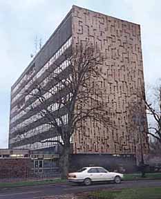
safely negotiated busy Grosvenor Road, we, until very recently, would have been immediately struck by the large,
ugly and to my mind, extremely inappropriately-sited building at the junction
with Nicolas Street- the busy Inner Ring Road- on our right. This was the County Police Headquarters, designed by the County architect,
Edgar Taberner and built between 1964 and 1967, at the astonishing cost
for the time of over half a million pounds. aving
safely negotiated busy Grosvenor Road, we, until very recently, would have been immediately struck by the large,
ugly and to my mind, extremely inappropriately-sited building at the junction
with Nicolas Street- the busy Inner Ring Road- on our right. This was the County Police Headquarters, designed by the County architect,
Edgar Taberner and built between 1964 and 1967, at the astonishing cost
for the time of over half a million pounds.
The 'sculpted' ends of this otherwise
drab block were designed by W. G. Mitchell and were made by pouring concrete
onto polystyrene moulds. They actually won a National Civic Trust award in 1969, even though the local branch objected to the building's design. Mind you, three decades later in the pages of 2000 Years of Building, they were praising it again: "It makes an important and positive townscape contribution... a particulary successful link with the castle opposite."
Architectural commentator Nikolaus Pevsner wrote of the building: "Extremely objectionably sited, an eight-storey block immediately
by the propylaea of the castle and turning towards it a windowless wall
with an agressive all-over concrete relief".
The Royal Fine Art Commission criticised the design around the same time. However, Donald Isall, in his influential report of 1968, cited the building as "an example of beneficial change within the city". He found it to be "well related to Grosvenor Street and the Castle."
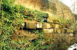
Incorporated
into
the
lower
parts
of
the
Police HQ
were
sandstone
blocks
from
the
castle-like Militia
Buildings which
formerly
occupied
the
site.
Built
just
after
the
Crimea
War
in
1854-6,
they
were
used
as
married
quarters
for
the
families
of
troops
serving
at
the Castle.
You
can
see
them
in
the
photograph
below,
which
also
shows
Chester's
forgotten
'Beefeaters'-
dressed
similarly
to
their
surviving
brethren
at
the
Tower
of
London-
the Javelin
Men who
once
escorted
the
Judge's
coach
to
the
assizes
at
the
Castle. A fascinating short British Pathé newsreel of them from 1926 may be seen here...
In
February
1998 it
was
reported
that
the
police
intended
to
move
out
of
their "crumbling"
30
year-old
building,
as
it
was
"too
cramped".
The
city
force
had
confirmed
a move
to
the
site
of
the
recently-demolished
Arts
Centre
in
Blacon
and
were
looking
for
a location
for
a city
centre
base
while
their
County
colleagues
wished
to
relocate
elsewhere
in
Cheshire.
The
date
for
this
move
was
said
to
be
sometime
in
2003.
What
then
would
be
the
fate
of
their
present
building
was,
at
the
time,
anybody's
guess-
a
report
that
it
was
to
demolished
to
make
way
for
a hotel
had
been
officially
denied,
which
led most locals to believe that
there was
probably
something
in
it.
Whatever
the
case,
few
would
be
sorry
to
see
it
go-
they
only
hoped
that
the
building
that
eventually
replaced
it
would
be,
for
a change,
something
the
city
could
be
proud
of.
Three years later, in February 2001, the building was formerly put up for
sale and, it was reported, "A number of potential developers, including leading
hotel chains, have made their interest known".
The city council's Design
and Conservation Manager commented that "There are two alternatives, either
keep the building and refurbish it, or replace it. There has been a lot of debate
about the present building and there are mixed feelings about it, but it is of
architectural importance, is a gateway site for the city and is in a conservation
area. In addition, the space around the building is protected and contains very significant archaeology".
A year later, in February 2002, city council planners duly recommended that the building be demolished to make way for a "prestigious" new development. They have made it known thay they would favour a three or four-storey building that would create jobs, such as a hotel, leisure or conference centre. It had emerged that Cheshire Police would be relocating to their new purpose-built headquarters at Woodford Business Park in Winsford at the end of 2003 and the site would become available for redevelopment soon after.
 Even those self-appointed guardians of our city's heritage, the Chester Civic Trust, who, just a few years ago, thought it would be a good idea to build a bunch of glass-and-steel office tower blocks at the Old Port, to "provide a 'gateway' to the city and be a commercially stimulating centrepiece
for the revival of the area" decided not to campaign for the preservation of the building. They were, however, "cautious" about the prospect of outright demolition and were said to recognise the value of a building "so clearly of its time"- and suggested that a "sensitive refurbishment" may have been more appropriate. Even those self-appointed guardians of our city's heritage, the Chester Civic Trust, who, just a few years ago, thought it would be a good idea to build a bunch of glass-and-steel office tower blocks at the Old Port, to "provide a 'gateway' to the city and be a commercially stimulating centrepiece
for the revival of the area" decided not to campaign for the preservation of the building. They were, however, "cautious" about the prospect of outright demolition and were said to recognise the value of a building "so clearly of its time"- and suggested that a "sensitive refurbishment" may have been more appropriate.
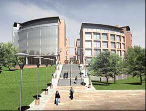
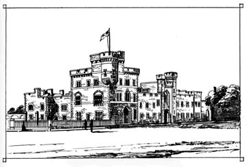
Right and below left: these early 'artist's impressions' were how the HQ Building was first presented to the public. The final design, below right, was, in the opinion of many, a great improvement.
In this, they were as successful as they were trying to save the Militia Buildings, the police HQ's predecessor. But then,
their national organisation did give the thing an award, "for its outstanding architectural contribution to the local scene" back in 1969.
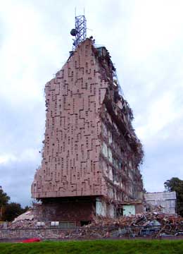
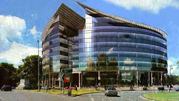
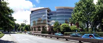
Above we present a final photograph of the half-demolished Police HQ in October 2006- and (right and below) some first views of the brave new building by Liberty Properties PLC now (Summer 2008) rapidly rising as its replacement.
This enormous new structure, to be known as 'HQ', was to feature a hotel, conference centre, offices and apartments as well as bars and restaurants set around an internal circular public piazza.
But then, in the Summer of 2009, a row broke out when it was proposed by the leadership of the newly-formed Cheshire West and Chester Council ( a new creation formed after the demise of the old Chester City and Cheshire County Councils) that County Hall, home of the County Council since 1957, should be sold to the rapidly-expanding Chester University for £10 million and that the council should take up offices within the newly-built HQ Building instead. The details may be found here.
Novemember 2009: Our council have now acquired all of the office space within the HQ development. An article on the Hill Dickinson website explains all. (We were amused by the brief final sentence in this piece, "The council advised itself").
The Minor Religious Houses
 In Roman times, all of the land we see ahead of us between here and the distant towers on the NW corner of the City Walls was part of the civil settlement, lying west of the Legionary fortress and adjacent to the quays situated along the banks of a much more substantial river than we see today. In its southern part have been discovered the remains of several substantial houses and north of these, a small tributary river once ran westwards to join the Dee but this had been drained and partially infilled during Roman times- although the land remained low-lying and boggy for centuries to come. In Roman times, all of the land we see ahead of us between here and the distant towers on the NW corner of the City Walls was part of the civil settlement, lying west of the Legionary fortress and adjacent to the quays situated along the banks of a much more substantial river than we see today. In its southern part have been discovered the remains of several substantial houses and north of these, a small tributary river once ran westwards to join the Dee but this had been drained and partially infilled during Roman times- although the land remained low-lying and boggy for centuries to come.
Little is known of the area in the centuries following the withdrawal of the Legions but it seems have been relatively little used. The River Dee, however, was undergoing major changes as falling sea levels and silting resulted in the once-busy harbour becoming landlocked and the large tract of land that now lies between the river and the city- the Roodee we know today- started to be formed.
 The other major change to the area was the creation of the City Wall upon which we now stand- which, to the surprise of many, did not actually exist on this side of the city until the early 12th century- to enclose this area within the defended circuit. This did not apparently result in any great immediate outburst of urbanisation, however, and most of the great area between the Castle and the North Wall long remained open land- known as The Crofts- and was utilised as smallholdings, gardens and orchards- land of relatively little value that could freely be granted for the founding of religious houses. Which, as we will learn, between the mid-12th to mid-13th centuries, is exactly what happened. The other major change to the area was the creation of the City Wall upon which we now stand- which, to the surprise of many, did not actually exist on this side of the city until the early 12th century- to enclose this area within the defended circuit. This did not apparently result in any great immediate outburst of urbanisation, however, and most of the great area between the Castle and the North Wall long remained open land- known as The Crofts- and was utilised as smallholdings, gardens and orchards- land of relatively little value that could freely be granted for the founding of religious houses. Which, as we will learn, between the mid-12th to mid-13th centuries, is exactly what happened.
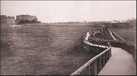
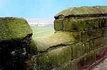
In Roman times, the ground on this side of the city west of the present day Inner Ring Road sloped sharply westwards down to the river bank and this slope was eventually cut into three terraces to produce level platforms for buildings and agriculture. The lowest of these terraces was fronted by the massive stone retaining wall which formed the Roman quayside, parts of which may still be seen on the Roodee today (see photograph below).
The City Wall was eventually built on top of this lower terrace, about five metres back from its edge. Immediately north of the site, however, the quay ran across the mouth of the small drained river valley, presumably in the form of a causeway, isolating the valley from the river. Behind the causeway there was only soft ground, unsuitable for erecting a large wall on, so consequently the wall deviates westward and was built close to the quay edge- probably on top of the causeway itself.
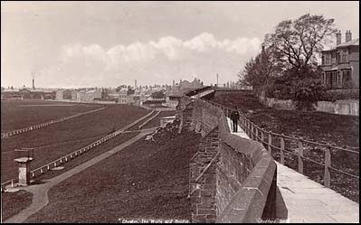
The erection of this great wall produced a barrier at the foot of the hillside against which deposits washed down from the slopes above could accumulate, a process that continued from the 12th century right through to fairly recent times. The result is that the entire sloping hillside has disappeared beneath around five metres of accumulated deposits and the ground level we walk on today is now more or less level with the top of the wall. Looking over the parapet at the drop below (see the old photograph below) and the City Wall's great supporting buttresses makes the situation dramatically clear and explains why the walls appear so different on this side of the city to those elsewhere in the circuit.
 The last traces of the boggy former tributary valley were filled in around 1827 by the construction of the great embankment to carry the approach road to the Grosvenor Bridge. The last traces of the boggy former tributary valley were filled in around 1827 by the construction of the great embankment to carry the approach road to the Grosvenor Bridge.
Left: Even 150 or so years ago, things hereabouts looked very different from today, as you see in these interesting photographs, showing the Roodee much as we know it, but, above, Nun's Road was an uneven grassy track snaking its way along the top of the wall. Below, earlier- and stranger- still, before villas started to appear, there is nothing but open land from the West Wall to the Castle.
Commencing in the 1150s most of the Crofts were to be occupied by the houses of religious communities. Nontheless, much of the land remained unbuilt-upon, serving in its ancient role as the fields and vegetable gardens of the monks and nuns. After the dissolution of the monasteries in the 1530s and 40s, their estates were gradually split up and developed- the final section, Lady Barrow's Hey, at the far end of the road, as late as 1963, when the site was occupied by the extension of the Chester Royal Infirmary (which we will visit soon)- which itself was demolished in 1998 to make way for new housing.
 Passing the boarded-off site of the recently-demolished Police HQ, we
find ourselves
standing
in Nun's
Road,
so
called
because
it
occupies
part
of
the
lands
of
the
Benedictine Nunnery
of St. Mary's which
stood
on
the
site which was later occupied by the
Police
HQ
from
Saxon
times
until
the
reign
of
Henry
VIII- when, in
1537,
along
with
the
neighbouring
houses
of
the
Black,
White
and
Greyfriars,
it
was
dissolved
and
the
nuns
cast
out
to
fend
for
themselves. (it
was,
however,
recorded
that
the
Prioress
and
eleven
other
nuns
were
given
pensions
which
they
were
still
receiving
21
years
later,
in
1556). Passing the boarded-off site of the recently-demolished Police HQ, we
find ourselves
standing
in Nun's
Road,
so
called
because
it
occupies
part
of
the
lands
of
the
Benedictine Nunnery
of St. Mary's which
stood
on
the
site which was later occupied by the
Police
HQ
from
Saxon
times
until
the
reign
of
Henry
VIII- when, in
1537,
along
with
the
neighbouring
houses
of
the
Black,
White
and
Greyfriars,
it
was
dissolved
and
the
nuns
cast
out
to
fend
for
themselves. (it
was,
however,
recorded
that
the
Prioress
and
eleven
other
nuns
were
given
pensions
which
they
were
still
receiving
21
years
later,
in
1556).
Their
estate and
buildings
survived,
and in 1542 were granted to Urian Brereton and became the Chester house of the Breretons of Handforth for the next hundred years. By the time of the Civil war in 1642-6, this was
the
home
of Sir
William
Brereton- at least until he became leader of the Cheshire Parliamentary forces- early in 1643 the buildings were attacked and pillaged by Welsh soldiers who formed part of the Chester garrison loyal to the King.
Norman
Tucker's
stirring
novel
of
1949, Master
of
the
Field (unfortunately
no
longer
in
print but well worth trying to find)
dramatically
recreates
Sir
William's
home
as
it
was
at
this
time,
as
well
as
being
a powerful
evocation
of
the
stirring
event
during
the
long
and
bloody Siege
of
Chester,
when,
along
with
many
other
buildings
within
and
without
the
walls,
the
Priory
buildings
were largely
destroyed and
their remains left to fall into decay.
The site was finally cleared and grassed over to form a fitting approach to the newly rebuilt Castle and today
not
a trace
remains
above
ground. An
archway
from
the
old
priory
was,
however,
re-erected
to form a 'folly' at St. John's Priory, a private house that once stood in the churchyard at St. John's Church and was the home of the mother of the 'English Opium Eater', Thomas De Quincey.
 When that house was removed, the arch was transferred to Grosvenor
Park,
where
it
may
still
be
seen today
(together
with
an
arch
from St. Bridget's
Church which
stood
for a thousand years in
Lower
Bridge
Street before being demolished to make way for Grosvenor Street,
and
the
ancient Shipgate,
which
we
learned
about
earlier
in
our
walk). Some of the old convent's stones were also incorporated into the rebuilt porch of the church of St. Mary-Within-the-Walls, next to the Castle. It was recorded that, when the site was cleared, many bones were uncovered, together with fragments of doors and windows and other masonry- some of Norman style others in the richer manner of the 15th century, painted and gilt-encrusted. When that house was removed, the arch was transferred to Grosvenor
Park,
where
it
may
still
be
seen today
(together
with
an
arch
from St. Bridget's
Church which
stood
for a thousand years in
Lower
Bridge
Street before being demolished to make way for Grosvenor Street,
and
the
ancient Shipgate,
which
we
learned
about
earlier
in
our
walk). Some of the old convent's stones were also incorporated into the rebuilt porch of the church of St. Mary-Within-the-Walls, next to the Castle. It was recorded that, when the site was cleared, many bones were uncovered, together with fragments of doors and windows and other masonry- some of Norman style others in the richer manner of the 15th century, painted and gilt-encrusted.
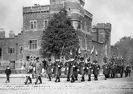
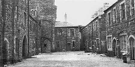
Left: Guarded by the Javelin Men, the coach carrying the Judge and High Sheriff to the Chester Assizes at the Castle pass before the impressive Militia Buildings which stood where the new HQ development is now. The inner courtyard of the Militia Buildings may be seen below. Another photograph of the Javelin Men may be seen on our Chester Castle pages and they and the Militia Buildings may be seen again in our Chris Langford gallery.
As previously mentioned, the construction of later buildings on the site have resulted in the probable complete destruction of the remains of the nun's church and its cloister. Much else, including the outer court and the 16th century mansion of the Breretons still survive beneath the formerly-landscaped area to the north west of the site. Will they be properly investigated this time- even, who knows, preserved in situ- before the new development takes place?
Today's developers allow, and may even help to fund excavations, but frequently commercial pressure to build on ancient sites, especially those incorporating basements or underground car parks, often allow archaeologists only a brief time to complete their work before the remains are obliterated. Dennis Petch's terse description of the destruction of a great Roman bath house on the site of the Grosvenor Shopping Precinct is a classic example. Future generations will doubtless think us very foolish.
The
Nuns
of
St.
Mary's originated
as
a poor
order,
and
indeed
for a long period had
great
difficulty
making
ends
meet.
Later,
Royal
patronage
and
liberal
bequests
ensured
the
nunnery
became
very
rich, owning property in most of the streets of Chester as well as land in Cheshire, Lancashire and even as far as South Wales.
Though they are centuries dead and the stones of their church scattered and lost, a part of them remains with us today, for, around the year 1425 was composed within the walls of the nunnery the beautiful Carol (or Song) of the Nuns of Chester which forms part of the repertoire of choirs throughout the world and is widely available in numerous recordings. Go
here to
learn
more
about
them.
 Passing along Nun's Road, we soon come to a narrow lane on the right bearing the evocative name of Blackfriars. This marks the approximate boundary between the precincts of the nuns of St. Mary's and the Dominican Friary, whose lands extended from here almost as far as Watergate Street. Passing along Nun's Road, we soon come to a narrow lane on the right bearing the evocative name of Blackfriars. This marks the approximate boundary between the precincts of the nuns of St. Mary's and the Dominican Friary, whose lands extended from here almost as far as Watergate Street.
The Dominicans, or Black Friars, were the first to establish themselves in Chester, founding their house here around 1236 (only fifty years after the first English Dominical foundation, at Oxford) and they dedicated their church to St. Nicolas. Documents show that a previous chapel, also dedicated to that saint, already existed on the land they acquired and they presumably used it before their own church was completed. By 1276, work had progressed so far that the monks built a pipeline from the natural springs (that had been in use since Roman times) at Boughton, 2 kilometers away, to supply their domestic quarters and kitchens with fresh water. The monastery was completed sufficiently for the Provincial Chapter of the Dominican order to be conducted here over three days in 1312.
Their church was rebuilt and expanded at least three times during the three centuries of occupation of the site and the last, and grandest, was still incomplete when the Friary was dissolved. During the decade before the Dissolution, the monks made many leases of land, perhaps in an attempt to make provision for themselves when the end came or possibly in an optimistic attempt to raise funds to complete their ambitious building programme in the unlikely event of their house being spared. One such was to Ralph Waryn in May 1537 and included "lands, gardens and orchards with two old chambers and a ruinous building, with the surrounding stone walls on the east and north of the house and church" and another, a mere two months before the surrender, to Richard Hope for "three houses lying together at the lower end of the church with the parish of Saint Martin".
 All was to no avail however, and the Dominicans, together with the other two Chester friaries, surrendered their house to Henry VIII's commissioners on 15th August 1538. An inventory of the buildings and contents were made which, aside from the stained glass in the windows and the lead on the roofs, found "little of value"- the monks having presumably disposed of all vestments, plate and other valuables bore the inevitable befell them. All was to no avail however, and the Dominicans, together with the other two Chester friaries, surrendered their house to Henry VIII's commissioners on 15th August 1538. An inventory of the buildings and contents were made which, aside from the stained glass in the windows and the lead on the roofs, found "little of value"- the monks having presumably disposed of all vestments, plate and other valuables bore the inevitable befell them.
Right: the inner courtyard of the vanished Militia Buldings which once stood where the brand-new HQ development is now.
The estate was leased to Thomas Smythe and Richarde Sneyde who (or perhaps their successors) eventually 'asset stripped' it, demolishing the buildings and disposing of the finely-cut blocks of masonry and the fixtures and fittings for use elsewhere. Their demolition and levelling of the site was so thorough that subsequent archaeological excavation (which was much more thorough than at St. Mary's Convent) found very little masonry surviving above the foundations- and even much of that had been dug out.
Pits discovered on the site were used for lead smelting, probably from the recovery of lead from the monastery's roofs and windows. There were some survivals, however, at least for a while. One early 17th century record, referring to the church, stated, "it stood in St. Nicolas Street and belonged to the Black Friars, and the great gate is yet remaining in the wall on the west side about the middle of the street". This gate may be seen on John Speed's 1610 map of Chester.
 Some fragments survived for much longer- in his 1856 work, The Stranger's Guide to Chester, Thomas Hughes, after a description of the Roodee, wrote, "we will now return to the Walls, noticing as we pass through the Water Gate, to the right, the remains of the wall of the Black Friars' Monastery". Some fragments survived for much longer- in his 1856 work, The Stranger's Guide to Chester, Thomas Hughes, after a description of the Roodee, wrote, "we will now return to the Walls, noticing as we pass through the Water Gate, to the right, the remains of the wall of the Black Friars' Monastery".
In the course of time, the estate was split up and developed but many of these modern property boundaries are aligned on the long-vanished Friary church and its associated buildings. We shall learn a little of the third of the monasteries, that of the Franciscans, that once existed on this side of the city- and also of a further religious community, the Carmelite White Friars- when we reach the Watergate.
Looking
over
the
parapet
here
we
see
the
great
buttresses
which
support
the
wall
all
along
this
side
together
with
the
immense
weight
of
earth
and
masonry
behind. If
you
look
at
the
triangular
coping
atop
this
stretch
of
wall,
you
will
see
a number
of
gaps-
unnoticed
by
virtually
all
who
pass
by-
but
in
fact
truly
remarkable
survivors
of
a savage
age:
original
relics
of
Chester's
ancient
battlements,
representing
the
lower
part
of
the crenelles or embrasures-
the
openings
through
which
soldiers
discharged
their
weapons
before
retiring
behind
the
higher
parts,
the merlons,
to
reload.
At
that
time
of
course,
these
battlements
stood
much
higher
relative
to
the
walkway
and
would
have
afforded
considerable
protection.
The
Roodee
From
this
point
until
we
reach
the Watergate,
below
us
stretches
the
beautiful
65-acre Roodee,
the
"sweet
rood
of
Chester"
(Gascoigne
1575)-
whose
curious
name
derives
from
the
Saxon Rood-
a
cross
or
crucifix
and
the
Norse
suffix Eye-
meaning
an
island,
thus
literally
'The
Island
of
the
Cross'.
In
Saxon
times,
the
waters
of
the
Dee
covered
the
whole
of
this
area
with
the
exception
of
a
small
island
upon
which
stood
a
stone
cross,
the
stump
of
which
you
may
still
see
in
the
middle
of
the
racecourse
today.
It
seems,
however,
to
have
been
moved
during
the
last
150
years-
Batenham's
map
of
1823
shows
it
situated
further
north
on
the
Roodee,
opposite
the
end
of
Greyfriars,
and
Hemingway,
thirteen
years
later,
records
that
it
was
placed "to
mark
the
boundary
of
the
land
there
belonging
to
the
Nuns
of
Chester", which
confirms
its
former
location.
Tradition
tells
us
that,
around
AD946,
the
cross
was
erected
over
a
statue
of
the
Virgin
Mary,
which
floated
to
Chester
up
the
river,
having
been
ejected
from Hawarden
Church for
falling
on-
and
killing-
the
Lady
Trawst,
wife
of
Sytsylht
(a
nobleman
and
governor
of
Hawarden
Castle)
whilst
she
was
at
prayer
asking
for
rain-
there
being
at
the
time
a
severe
drought.
Her
Lord
was
outraged,
assembled
a
jury,
recorded
as:
Hincot
of
Hancot,
Span
of
Mancot,
Leech
and
Leach,
and
Cumberbeach;
Peet
and
Pate,
with
Corbin
of
the
Gate,
Milling
and
Hughet,
with
Gill
and
Pughet,
- and
put
the
statue
on
trial
for
murder!
She
was
convicted-
also
being
found
guilty
of
not
answering
her
accusers-
and
condemned
to
be
hanged.
One
juryman
opposed
that,
saying
that,
as
they
wanted
rain,
it
would
be
best
to drown her.
Another
argued
that,
as
she
was
'Holy
Rood',
they
had
no
right
to
kill
her,
but
he
suggested
that
they
lay
her
on
the
sands
on
the
river
below
Hawarden
Castle,
that
God
might
do
what
he
would
with
her.
This
they
did,
and
the
tide
took
her
down
river
to
Chester,
where
the
inhabitants
found
her,
"dead
and
drowned"
upon
which
they
buried
her
where
she
was
found
and
raised
over
her
a
stone
cross,
which
is
said
to
have
borne
the
following
inscription:
The
Jews
their
God
did
crucify,
The
Hardener's
theirs
did
drown,
Cause
with
their
wants
she'd
not
comply;
And
lies
under
this
cold
ground.
Even
earlier,
in
Roman
times,
the
river,
which
was
then
much
wider
and
deeper,
flowed
right
up
to
what
is
now
the
base
of
the
medieval
city
wall.
Remember
that
the
Roman
wall
was
set
much
further
back
than
this,
running
along
the
line
of
the
present
inner
ring
road,
between St.
Martin's
Gate and
the Newgate-
the
present
wall
resulting
from
the
Saxon
expansion
of
the
fortress
in
the
10th
century.
 If
you
walk
down
the
steps
to
the
racecourse
and
grub
about
behind
a
lot
of
brambles,
debris
and
portable
buildings,
you
will
be
rewarded
with
the
sight
of
the
massive
stones
of
what was once the Roman
harbour
wall,
(right)
where
once
war
gallies
tied
up
and
the
trading
ships
of
the
empire
discharged
their
cargoes
of
wine
and
spices.
Although
only
a
few
courses
of
these
stones
show
above
ground,
they
extend
for at
least another
15
feet
underground
for
much
of
the
length
of
the
wall
between
here
and
the Watergate,
with
traces
of
groin
walls
running
off
at
right
angles.
(Investigation
beyond
this
depth
was
curtailed
because
of
flooding
by
the
water
which
still
endures
below
ground
level). If
you
walk
down
the
steps
to
the
racecourse
and
grub
about
behind
a
lot
of
brambles,
debris
and
portable
buildings,
you
will
be
rewarded
with
the
sight
of
the
massive
stones
of
what was once the Roman
harbour
wall,
(right)
where
once
war
gallies
tied
up
and
the
trading
ships
of
the
empire
discharged
their
cargoes
of
wine
and
spices.
Although
only
a
few
courses
of
these
stones
show
above
ground,
they
extend
for at
least another
15
feet
underground
for
much
of
the
length
of
the
wall
between
here
and
the Watergate,
with
traces
of
groin
walls
running
off
at
right
angles.
(Investigation
beyond
this
depth
was
curtailed
because
of
flooding
by
the
water
which
still
endures
below
ground
level).
The
visitor
passing
by
at
pavement
level
is
told
a
little
of
the
vanished
Roman
harbour
on
one
of
a
series
of
information
panels
which
of
recent
times
have
sprouted
at
strategic
locations
around
the
walls-
but
it
is
nontheless
a shame
that
this
most
evocative
of
relics
of
the
founders
of
our
city
should
currently
be
so
poorly
presented.
Roman Cemetery
It is strange that, so close to the bustle of the old harbour, a cemetery also existed here in those far-off Roman times and a number of burials have been discovered along the grassy embankment beneath the City Wall. A contributor to The Cheshire Sheaf, one F. H. W., told of a number of these in that journal in 1882- at the same time giving us a vivid impression of the exceedingly casual attitude with which ancient finds such as this were treated at the time- "The first interment we are acquainted with occurred near here in the ground under the south, end of the Dee Stands, I cannot furnish particulars, but have been told that a small, though perfect, Samian-ware vessel now in the collection of Mr. Frederick Potts was taken from this tomb.
In repairing the steps above-mentioned several years ago, the bones of a young person were found in the ground beneath: indeed the grave was described to me as being partly situated in an oblique position, and under the Walls; also that a Roman coin (second brass I think) had been deposited with the body. Mr. Shrubsole possesses the lower jawbone of the skeleton. At the same spot, only lower down the bank, a third grave was uncovered; but in this case the remains were surrounded by a coffin-like cist composed of small squared pieces of red sandstone.
The next to be noticed was found on the top of this bank in 1865, between the first and second buttresses, counting from the steps referred to. It lay at about a foot below the surface, and was composed of the ordinary red clay Roman roofing tiles (tegulae). A silver denarius of the Emperor Otho accompanied the skeleton, which was almost entire, and in its original position.
At no great distance from this, an interment was met with which may be considered as one of the most interesting yet discovered at Chester; from the circumstance that a head-stone was disinterred at the same time, which there is every reason to believe once marked the grave. This occurred in June 1874, when a cutting was made across the Roodeye, in order to form the intercepting sewer from Boughton, and running under the County Gaol. I shal here give one or two quotations from the description of Mr G W Shrubsole, who was present after its discovery:-
"The excavation commenced near the Castle, along the south face of the little-Roodee. On passing the angle of the Walls, clay and rock were found, and when the Grosvenor Bridge embankment was reached, tunnelling through rock was resorted to. Reaching the Roodee- proper, an open cutting was begun, and continued across to the Watergate. Soon after passing the Grosvenor Bridge embankment the workmen came upon a large flat stone, which proved to have an inscription of the Roman age."
This slab, formed of the ordinary red sandstone of the district, is inscribed in perfectly legible characters—
D. M.
F. L. CALLIMOR
PHI . VIX . AN . XXXXIi .
ET . SERAPIONI . VIX .
ANN . III . M. VI . T . HE . SA .
EVS . FRATRI . ET . FILIO .
F. C. |
Which has been thus translated by Mr Hughes,— "To the divine shades of Flavius Lucius Callimorphus, who lived 42 years, and to Serapion, who lived 3 years and 6 months. Thesa caused this to be erected to her Brother and his Son."
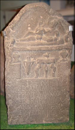 As is frequently the case in monuments of this class, the upper portion is obtusely pointed, and has a species of tympanum or recessed compartment, with a carving in relief, representing Callimorphus on a couch in a recumbent posture, with his son Serapion resting on his lap. Near the side of this couch or bed is a small, gracefully formed stand; and, to the left of this, an unmistakeable amphora. Height of the slab, 4 feet 2 inches; width, 2 feet 3 inches; and average thickness about 6 inches. As is frequently the case in monuments of this class, the upper portion is obtusely pointed, and has a species of tympanum or recessed compartment, with a carving in relief, representing Callimorphus on a couch in a recumbent posture, with his son Serapion resting on his lap. Near the side of this couch or bed is a small, gracefully formed stand; and, to the left of this, an unmistakeable amphora. Height of the slab, 4 feet 2 inches; width, 2 feet 3 inches; and average thickness about 6 inches.
Right: the gravestone of Callimorphus and Serapion, resting now in the wonderful Roman Stones Gallery in the Grosvenor Museum.
I again quote Mr. Shrubsole's remarks: "The Inscribed Stone was found between the second and third buttresses of the Walls, counting from the Grosvenor Road, and 40 feet west from the Walls, and within the ring of posts which spans the Roodee, but 6 feet from the outer line. It narrowly escaped being broken up to facilitate its removal from the trench. The grave had been dug nearly east and west; the head was towards the river, the feet to the Walls. The excavation cut through only a portion of the grave. The only bones I saw were two human skulls, one of them larger than the other, and some belonging to the upper part of the body. Other bones could be seen protruding on the east side of the cutting, and were not disturbed by me. I declined the gift of them, and in the filling in of the trench they were deposited close to their former resting place. The finding of a gold ring and a Roman coin among the filled-in rubbish composing the grave, is quite in accordance with what we should expect to find at a Roman burial. With regard to the ring, I ought to say that I never saw it. It was described to me as large, and massive in character. The man who found it left the city the next day. The Roman coin I examined- it was a second brass of Domitian in poor condition.
Passing again over the bank in May 1881, 1 noticed, washed bare by the rain, some osseous substance protruding from the soil within a foot or so to the south of the third buttress counting from the steps below Black Friars. Being well aware of the nature of the ground, I suspected that it might be a human skull; and on removal with the point of my stick it proved to be so. A subsequent examination revealed the rest of the skeleton, which lay with its head to the north and the feet to the south, about a foot from and parallel with the Walls.
On re-visiting the spot in the June of the same year another rounded object, from which the soil had been denuded, was presented to my view. This I at first mistook for the polished surface of a boulder, but soon recognised its real nature. The body had been laid in the same position as the last, and parallel with the Walls, only lower down, and a little further south. I searched carefully among the earth from within and around each skull, in the hope of finding a coin- Charon's toll- but did not succeed. And in neither case did I meet with any traces of a coffin, or with any of the objects usually found in such situations. The two skulls, the first of which came all to pieces, I have restored as far as possible and placed in the Museum of the Chester Archaeological Society [now the Grosvenor Museum]. The skull from the upper grave was broken in through the right side (which was exposed) before I saw it. The second is almost perfect; yet so great is the contempt with which the lower classes regard such matters, that had I not removed them they would, possibly shortly afterwards, have been utilised as footballs on the green sward below”.
Many more fascinating and well-preserved Roman gravestones are displayed alongside that of Callimorphus and Serapion in the Grosvenor Museum- a visit to which should be considered essential when you come to Chester. Most of these were, remarkably, discovered embedded within the North City Wall when repairs were being undertaken there in the nineteenth century. Learn more about them here.
While
you
are
down
here, walking upon the Roodee,
look
out
for
the
square
stone
column
surmounted
by
a
railed
enclosure,
known
as
the Judge's
Chair-
a
relic
of
18th
century
racing
days.
This
column
is
the
surviving
one
of
a
pair,
the
other
having
stood
directly
opposite,
on
the
far
side
of
the
course.
Around
1615,
the
Roodee
was
described
as "a
very
delightful
meadow
place,
used
for
a
cow
pasture
in
the
summertime;
and
all
the
year
for
a
wholesome
and
pleasant
walk
by
the
side
of
the
Dee,
and
for
recreations
of
shooting,
bowling
and
such
other
exercises
as
are
performed
at
certain
times
by
men;
and
by
running
horses
in
presence
and
view
of
the
mayor
of
the
city
and
his
brethren;
with
such
other
lords,
knights,
ladies
and
gentlemen
as
please
at
these
times,
to
accompany
them
for
that
view".
In
1636, "The
mayor
caused
the
durt
of
many
foule
lanes
in
Chester
to
be
carried
to
make
a
banke
to
enlarge
the
Roodey
and
let
shipps
in.
It
cost
about
£100".
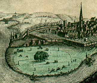 Here we
see
a
view
of
the
Roodee-
a
small
detail
from
this view
of
Chester-
which
appeared
in
the London
Magazine in
1753.
Sailing
ships
navigate
the River
Dee and
beyond
the Watertower at
the
angle
of
the
city
walls,
open
land
stretches
as
far
as
the
eye
can
see.
Within
the
walls,
too,
are
large
areas
of
cultivated
fields.
(Just
eight
years
after
this
view
was
published,
the Infirmary would
be
built
on
part
of
these). On
the
right
rises
the
tall
spire
of Holy Trinity Chuch in Watergate Street. Here we
see
a
view
of
the
Roodee-
a
small
detail
from
this view
of
Chester-
which
appeared
in
the London
Magazine in
1753.
Sailing
ships
navigate
the River
Dee and
beyond
the Watertower at
the
angle
of
the
city
walls,
open
land
stretches
as
far
as
the
eye
can
see.
Within
the
walls,
too,
are
large
areas
of
cultivated
fields.
(Just
eight
years
after
this
view
was
published,
the Infirmary would
be
built
on
part
of
these). On
the
right
rises
the
tall
spire
of Holy Trinity Chuch in Watergate Street.
As the Dee continued to silt up, the area of permanently dry land increased and was declared to be part of the parish of this church, but, doubtless to the irritation of the clergy, could not be tithed as it was deemed to be land reclaimed from the sea. On
the
Roodee
itself,
a
horserace
is
in
progress.
Notice
the
apparent
lack
of
any
facilities
other
than
the
crude
marker
posts
erected
to
help
jockeys
navigate
the
course-
and this
despite
the
fact
that
organised
horse
races
had,
by
this
time,
been
held
here
for
well
over
200
years.
1753,
when
this
picture
appeared,
was,
interestingly,
the
year
that
a
permanent
racecourse
was
first
established
at Newmarket.
All of these interesting features may be better seen in a similar image of the Roodee, a detail from Nathaniel Buck's 1728 view of Chester.
The
Roodee's
rural
nature
survived
into
living
memory.
Writing
in
the
local
press
in
1999,
Mrs
J
Moore
recalled,
"I've
been
reminiscing
about
the
days
of
my
youth
when
cows
and
sheep
grazed
on
the
middle
of
the
big
Roodee
when
the
grass
was
higher
than
me.
It
was
cows
in
summer
and
sheep
in
winter.
I
can't
remember
when
they
started
to
cut
the
grass
by
machine-
some
time
after
the
war,
I
think. I
recall
cows
coming
up
and
down
Lower
Bridge
Street
on
their
way
to
the
cattle
market
at
Gorse
Stacks.
Tuesdays
and
Thursdays
were
days
when,
if
you
had
any
sense,
you
kept
away
from
the
Cow
Lane
Bridge
and
Brook
Street
area
unless
you
were
at
ease
with
cows,
bulls,
sheep,
pigs
etc.
The
cows
were
the
worst
(unless
the
occasional
bull
escaped)
They
went
into
shops,
and
so
did
the
public
trying
to
dodge
them-
hopefully
not
the
same
shops!
My
sister
worked
in
Brook
Street
and
remembered
many
a
heart-stopping
occasion.
At
least,
she
said,
in
Brook
Street
you
could
avoid
them,
but
if
you
met
the
herds
on
Cow
Lane
Bridge,
there
was
nowhere
to
hide!"
The Roodee Workhouse
 In centuries gone by, each parish was responsible for the welfare of its poor and destitute. By the start of the 18th century, a system of Poor Houses was introduced, one for each parish. The records of St Mary’s Parish show that the appointed Master of its Poor House was expected to abide by many rules, just a few examples being: In centuries gone by, each parish was responsible for the welfare of its poor and destitute. By the start of the 18th century, a system of Poor Houses was introduced, one for each parish. The records of St Mary’s Parish show that the appointed Master of its Poor House was expected to abide by many rules, just a few examples being:
“He cause the house to be swept from top to bottom every morn and washed once a week at the least.”
“A cloth be laid at every meal and the Poor sit at table in a decent manner and that grace be constantly said.”
“Neither children nor others go abroad on Sundays, but continue together in the House and read the Holy Scriptures or other good book.”
How far the reality corresponded with these ideals we shall never know. Much would depend of course on the type of person the Master was. Despite the regimented way of life, it is possible that the “inmates” were in fact better off than some of those parishioners struggling to make a living on the ‘outside’. They could at least expect three square meals a day and there is a record in St Oswald’s Parish of a woman being employed to teach the children of the Poor House to read.
With the cost of caring for the increasing numbers of poor becoming a great burden upon the individual parishes, a decision was made in 1757 to set up a general Workhouse or House of Industry for the whole of the city. Work began in 1758 on a “four-square rectangular brick building round a courtyard, at the north-west extremity of the Roodee,” and for over a century this building played a large part in the lives of many Cestrians. Not far from this was The Tower Field, of which in 1836 Hemingway wrote that it had "recently been rented by the guardians of the poor by the cultivation of which, by spade husbandry, able-bodied paupers were very properly and advantagiously employed". This Tower Field is known to us today as Water Tower Gardens, a pleasant little park, complete with tennis courts and a popular bowling green.
The Workhouse survived here by the Roodee until the late 1870s, when the Board of Guardians, formed in 1869, built a new workhouse in Hoole Lane (which later became the City Hospital before being demolished in the 1970s to make way for new housing. Only its chapel and graveyard survive today).
After the city’s paupers left, the Roodee Workhouse was put to use as a confectionery works by the Cheshire Preserving Company and it was apparently demolished between 1902 and 1906.
Go
on
to part
II of
our
exploration
of
Chester's
beautiful
Roodee...
 Curiosities
from
Chester's
History
no. 22 Curiosities
from
Chester's
History
no. 22
- 1659
Sir
George
Booth,
on
hearing
that
the
Parliamentarian
General
Lambert
was
appoaching
the
city,
marched
on
him
with
3,000
troops
and
engaged
him
in
battle
at
Northwich,
where
Booth
was
defeated.
Lambert
then
carried
on
to
Chester.
As
a
punishment,
Parliament
dissolved
the
Chester
Corporation
and
ordered
that
the
city
should
no
longer
be
a
separate
county.
However,
the
Parliamentarians
did
not
hold
power
long
enough
to
enforce
the
order.
- 1660
Parliament
invites Charles
II (1630-1685) to
return
to
England.
The
communion
table
from
St.Mary's-on-the-Hill
was
found
to
be
missing,
so
6d
was
spent
on
a
warrant
to
search
for
it
and
4d
spent
on
constables
"in
going
about
to
search
for
the
table". Samuel
Pepys starts
to
write
his
diary.
1661
Coronation
of
King
Charles
II.
No
Michaelmas
Fair
held
in
Chester
this
year
because
of
the
Plague. Daniel
Defoe born (-1731) . 1663
Turnpike
roads
introduced
into
England.
First
golden
guineas
coined-
and the Hearth
Tax was introduced in order to support the household of Charles II. 1664
The
'Bear
and
Billet
Inn'
in
Lower
Bridge
Street
was
built-
or
rebuilt-
this
year.
Standing
in
its
own
grounds,
it
was
originally
the
town
house
of
the
Talbot
family-
the Earls
of
Shrewsbury-
who
were
Sergeants
of
the
nearby Bridgegate.
They
later
leased
it
to
an
innkeeper,
on
condition
that
a
suite
of
rooms
was
always
kept
available
for
the
Earl
and
his
family.
It remains a fine pub to this day. (Go here to
read
about
some
more
old
Chester
pubs)
Charles
II
granted
the
city
a
new
Charter.
1669
The
spire
of
St.
Peter's,
at
the
High
Cross,
was
found
to
be
in
a
dangerous
condition,
and
taken
down.
- 1677
Mr
Andrew
Yarranton
took
a
survey
of
the River
Dee and
published
the
results
in
a
book
called
'England's
Improvement
by
Sea
and
Land'.
He
made
a
proposal
to
the
Duke
of
York
to
reclaim
a
large
area
of
land
from
the
sea
by
making
a
new
channel
which
would
carry
the
water
to
the
walls
of
Chester.
However,
no
interest
was
aroused
in
his
proposals,
so
he
abandoned
the
scheme.
The Roodee, 450 Years of Racing in Chester by R M Bevan. Available from Cheshire Books Direct www.cc-publishing.co.uk
Top
of
Page | Site
Index | Site
Front
Door | Chester
Stroll
Introduction | Grosvenor
Bridge | Roodee
part
II
|