  s
we approach the end of the Groves our hearing
is filled with the roar of water rushing over the weir and the scene is dominated
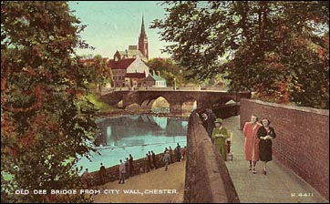
by a magnificent sandstone bridge crossing the river. This is the venerable Old
Dee Bridge, comprising seven unequal arches and built, much as we see it
today, about the year 1387 on the site of a succession of earlier wooden bridges
and a pre-Roman fording place. s
we approach the end of the Groves our hearing
is filled with the roar of water rushing over the weir and the scene is dominated
by a magnificent sandstone bridge crossing the river. This is the venerable Old
Dee Bridge, comprising seven unequal arches and built, much as we see it
today, about the year 1387 on the site of a succession of earlier wooden bridges
and a pre-Roman fording place.
The bridge is mentioned as part of Chester's entry in the Domesday
Book: "When, for the purpose of repairing or rebuilding the wall or the bridge of
the city, the proper officers commanded that one man be furnished from each
hide, the lord of such man that did not attend was fined fourty shillings to
the King and the Earl".
Successive bridges were washed away by flood tides in 1227, 1280, 1297 and 1353.
The later stone structure seems to have been more resistant to inundations:
on 16th January 1551, "There arose in the night a mighty great wind and the
flood came to such a height that many trees were left by the ebb, on the top
of Dee Bridge".
Thomas Pennant (1726-98), Flintshire landowner, naturalist and travel writer wrote of it in 1773, "The approach to the city is over a very narrow and dangerous bridge, of seven irregular arches, till of late rendered more inconvenient by the antient gateways at each end, formerly necessary enough, to provent the inroads of my countrymen, who often carried fire and sword to these suburbs; which were so frequently burnt, as to be called by the Britons Tre-boeth, or the burnt town"...
An older document records how, in the 13th century, Llewellyn, Prince of Wales "gathered a mighty band and with it inflicted much harm even unto the gates of the city of Chester. The city had often been affrighted with the like scare-fires and was lastly defended with a wall made of the Welsh-men's heads on the south side of Dee in Handbridge."
 Handbridge
was
burned
once
again,
but
this
time
by
the
citizens,
during
the
Siege
of
Chester
in
1645
to
prevent
Parliamentary
forces
taking
cover
there."Handbridge
has
once
again
become
Treboeth,
being
burnt
by
the
command
of
the
Governor
Lord
Byron
to
prevent
their
nesting
others"
wrote
one
of
the
besieged
in
his
diary. Handbridge
was
burned
once
again,
but
this
time
by
the
citizens,
during
the
Siege
of
Chester
in
1645
to
prevent
Parliamentary
forces
taking
cover
there."Handbridge
has
once
again
become
Treboeth,
being
burnt
by
the
command
of
the
Governor
Lord
Byron
to
prevent
their
nesting
others"
wrote
one
of
the
besieged
in
his
diary.
During
this
period,
both
sides
made
desperate
sorties
over
the
old
bridge
and
almost
incessant
fighting
occured
in
the
area,
a situation
difficult
to
imagine
as
we
gaze
upon
the
bustling,
but
peaceful
scene
today.
Despite the bridge being so vital to their prosperity, the citizens were often reluctant to assume responsibility for its repair, and in 1387 Richard II was persuaded to grant them sums of money for this purpose. Letters Patent granted to the citizens on 25 July 1387 state: "Know ye that of our special grace and at the supplication of our lieges, the Commonalty of our town of Chester, and for consideration that as many have been drowned in the water of the Dee since the bridge has been destroyed and broken. And also, because the same town for that reason is very greatly impoverished as we are informed, we have granted to the fabric and repair of the aforesaid bridge all the profits of the Passage of the said water at Chester and the Murage which used to be granted there for the walls, to be received until that bridge is rightly and reasonably completed".
Twenty years later, Letters Patent granted by Henry Prince of Wales and Earl of Chester, refer to "the completion and finishing of the Tower on the Dee Bridge begun in the time of Richard, late King of England".
 The anonymous author of A Walk Round the Walls and City of Chester, published in the first years of the nineteenth century, wrote about the Old Dee Bridge, "The bridge is built upon seven arches; the passage over it is very disagreeable, and indeed when crowded, rather dangerous, owing to its being so narrow; a new bridge would certainly add much to the convenience of the public and the appearance of the City". The anonymous author of A Walk Round the Walls and City of Chester, published in the first years of the nineteenth century, wrote about the Old Dee Bridge, "The bridge is built upon seven arches; the passage over it is very disagreeable, and indeed when crowded, rather dangerous, owing to its being so narrow; a new bridge would certainly add much to the convenience of the public and the appearance of the City".
The author's desired benefits of convenience and appearance actually came about thirty years later with the opening of the magnificent Grosvenor Bridge.
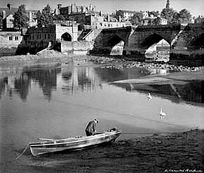
Left: a salmon fisherman attends to his nets before the Old Dee Bridge in this photograph by the famous Liverpool photographer Edward Chambré Hardman. See more of his splendid images of Chester and Liverpool here.
At
the
far
end
of
the
bridge
is
an
attractive
green
area
bordered
by
a mixture
of
19th
century
cottages
and the exceedingly ugly Salmon Leap apartment
blocks.
That their occupants enjoy some of the most magnificent views in the city is undisputed, but that
such
eyesores
could
have
been
allowed
in
such
a sensitive
location in the first place
has
long
been
a source
of
wonder
to
everyone else.
Soon
after
they
were
built,
in
1972,
the authors of the Chester
Riverside
Study commented dryly,"The
new
riverside
flats
at
Mill
Street
are
generally
regarded
as
an
unfortunate
design
for
this
location". Which
is
putting
it
mildly.
Their site was formerly occupied by industrial premises such as the factory of Messrs T. Nicholls, manufacturers of tobacco and snuff, which was established here in the 1780s. Those buildings were entirely demolished in the 1960s- our photograph shows them just before this event- the flats were built at the Old Dee Bridge end of the site and the rest was landscaped and a footpath to the Meadows constructed. At the far end, the Salmon Leap survives and the waterwheel which once powered Nicholl's snuff mill has been restored. A small generating station now stands where a smaller tobacco works and a tallow candle works used to be on Cherry Tree Island at the end of the weir.
 Standing close to the
Handbridge end of the bridge is The Ship Inn, whose licence can be traced back to 1770 when the licencee was Mr Stephen Hyde. During the period 1850-60, the licencee, Mr William Dutton, was a man of many talents, for as well as landlord he was also a practicing blacksmith, farrier and wheelwright. The Ship was indeed a waterside hostelry with around it, manufacturers of twine and rope for fishing nets. Fisher folk thronged the courts around Greenaway Street in old-time Handbridge, and they had the run of the river. They
all
had
their
own
jealously-guarded
named
spots
to
fish from,
such
as Marshead, Lane
End, Under
the
Hills, Crane and Littlewood. Standing close to the
Handbridge end of the bridge is The Ship Inn, whose licence can be traced back to 1770 when the licencee was Mr Stephen Hyde. During the period 1850-60, the licencee, Mr William Dutton, was a man of many talents, for as well as landlord he was also a practicing blacksmith, farrier and wheelwright. The Ship was indeed a waterside hostelry with around it, manufacturers of twine and rope for fishing nets. Fisher folk thronged the courts around Greenaway Street in old-time Handbridge, and they had the run of the river. They
all
had
their
own
jealously-guarded
named
spots
to
fish from,
such
as Marshead, Lane
End, Under
the
Hills, Crane and Littlewood.
Guide and author Joseph
Hemingway,
wrote
in
1835, "In
that
useful
article,
salmon,
no
market
in
the
kingdom
did,
some
few
years
ago,
excel
it;
indeed,
such
was
the
profusion
of
that
valuable
fish,
that
masters
were
often
restricted,
by
a
clause
in
the
indentiture,
from
giving
it
more
than twice
a
week to
their
apprentices.
Though
the
bounty
of
providence,
in
this
particular,
is
yet
unabated,
such
restriction
is
no
longer
necessary-
some
artificial
cause,
or
other
very
kindly,
rendering
this
fish,
at
the
present
day,
a
delicacy
even
to
the
masters
themselves...
The
supply
was
so
great,
that
after
furnishing
our
own
market
for
the
city
and
neighbourhood,
five
or
six
carts
were
employed
in
conveying
it
for
sale
to
distant
places".
Due to the increasing quantity of fish being taken from the river, by 1880, it was deemed necessary to introduce restrictions and Fishery Boards became responsible for licensing the fishermen. But at £5 a licence this proved a considerable financial burden so the Rector of the parish, Rev Henry Grantham, formed a Fishermen's Association for the encouragement of the salmon fishermen, with a penny bank to enable them to save for their licence. Each year he gave a ton of coal to the fisherman who caught the first Dee salmon. This later became a guinea paid by the Rector of Handbridge to the fisherman who brings the first salmon for him to see. Contrary to popular belief, the Rector does not receive the first salmon.
The Handbridge fishermen still ply their craft, and their fishing boats and nets can be seen below the bridge when the men are not out on the water. Nowadays, however, fishing does not bring in sufficient livelihood, and the majority of the fishermen also have other employment. Nor do they now live as once they did in Greenway Street- their simple cottages have given way to more modern dwellings but this old thoroughfare which rises uphill from the river retains its cobbles to this day.
 Until it was removed in 1850, a maypole once stood at the Handbridge end of the Old Dee Bridge. The American author, Washington Irving (best remembered today for his stories The Legend of Sleepy Hollow, in which the schoolmaster Ichabold Crane meets with a headless horseman, and Rip Van Winkle, about a man who falls asleep for 20 years)- recalled seeing it on a visit to Chester around 1825, "I shall never forget the delight I felt on first seeing a May-pole. It was on the banks of the Dee, close by the picturesque old bridge that stretches across the river from the quaint little city of Chester. I had already been carried back into former days by the antiquities of that venerable place... the May-pole on the margin of that poetic stream completed the illusion. My fancy adorned it with wreaths of flowers and peopled the green bank with all the dancing revelry of May-day. The mere sight of this May-pole gave a glow to my feelings and spread a charm over the country for the rest of the day". Until it was removed in 1850, a maypole once stood at the Handbridge end of the Old Dee Bridge. The American author, Washington Irving (best remembered today for his stories The Legend of Sleepy Hollow, in which the schoolmaster Ichabold Crane meets with a headless horseman, and Rip Van Winkle, about a man who falls asleep for 20 years)- recalled seeing it on a visit to Chester around 1825, "I shall never forget the delight I felt on first seeing a May-pole. It was on the banks of the Dee, close by the picturesque old bridge that stretches across the river from the quaint little city of Chester. I had already been carried back into former days by the antiquities of that venerable place... the May-pole on the margin of that poetic stream completed the illusion. My fancy adorned it with wreaths of flowers and peopled the green bank with all the dancing revelry of May-day. The mere sight of this May-pole gave a glow to my feelings and spread a charm over the country for the rest of the day".
A
footpath
here
will
take
you
back
to Queen's
Park
Bridge and
the Meadows,
or,
if
you
carefully
cross
the
busy
road,
next
to
the Ship you
will
see
the
entrance
to
a tree-lined
open
green
area.
Today
this
serves
as
a public
park
and
it
has
for
centuries
been
known
as Edgar's
Field,
being
the
legendary
site
of
the
10th
century
Royal
Palace
of
King
Edgar 'The Peacemaker'.
(Read the splendid old legend of how he was rowed on the River Dee to St. John's Church by six lesser kings here). Earlier
still,
there
was
a large
quarry
here
which
was
the
source
of
much
of
the
stone
used
in
the
construction
of
the
Roman
fortress.
This
was
a superior
material
to
that
used
by
some
later
generations
of
builders,
as
we
saw
when
we
visited
the Cathedral and
the Northgate. Excavations
have
shown
that
work
in
the
quarry
ceased
around
the
end
of
the
fourth
century
AD.
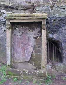 On
the
eastern
face
of
a remaining
sandstone
outcrop
may be seen a remarkable survivor-
a carved
Roman representation
of
the
goddess Minerva,
the
patron
of
all
rivers
and
springs
in
Britannia,
and
also
protector
of
of
soldiers
and
craftsmen.
Situated
as
she
is
here,
facing
the
bridge
and
the
ancient
route
to
the
south,
she
was
revered
as
the
protector
of
travellers.
Hemingway
calls
her
the Diva
Armigera
Pallas. Also
known
as Pallas and Athena,
she
was
one
of
the
most
popular
deities
and
was
worshipped
at
the five-day
March
festival
of Quinquatrix. On
the
eastern
face
of
a remaining
sandstone
outcrop
may be seen a remarkable survivor-
a carved
Roman representation
of
the
goddess Minerva,
the
patron
of
all
rivers
and
springs
in
Britannia,
and
also
protector
of
of
soldiers
and
craftsmen.
Situated
as
she
is
here,
facing
the
bridge
and
the
ancient
route
to
the
south,
she
was
revered
as
the
protector
of
travellers.
Hemingway
calls
her
the Diva
Armigera
Pallas. Also
known
as Pallas and Athena,
she
was
one
of
the
most
popular
deities
and
was
worshipped
at
the five-day
March
festival
of Quinquatrix.
Later
generations,
taking
her
for
the
Virgin
Mary,
also
worshipped
and
protected
her,
and
she
remains
with us to
this
day-
albeit
a severely
weathered
shadow
of
her
original
self-
and
claimed
to
be
the
only
representation
of
a Classical
goddess
still
in
its
original
position
anywhere
in
Western
Europe.
To quote again from A Walk Round the Walls and City of Chester, its author wrote in the opening years of the nineteenth century, "Over the bridge in the front of a rock in the field on the right is cut a rude figure of the Dea armigera, Minerva, with her bird and altar. Here were formerly some ancient buildings, whose scite is marked by certain hollows; for the ground, probably over the vaults, gave way and fell in, within the remembrance of persons now alive. Tradition calls the spot the scite of the place of Edgar, from whence he was rowed in the year 973 by eight tributary kings to the monastery of St. John Baptist, and back again to his palace."
Our photograph shows the shrine as it now is- a shocking mess. A fine information board was some time ago provided by the City Council, explaing the history of the shrine and included a reconstruction of the statue as it may once have appeared, finely detailed and painted in bright colours. This has now disappeared- doubtlessly due to the attentions of vandals- and only the metal poles that once supported it remain.
That said, during the Summer of 2010, with the assistance of The Friends of Edgars Field, a radical programme of improvements were undertaken, including repairs to the shrine, attractive and imaginative new equpment in the play area, tree maintainance and much more. The Friends are a group of local people who are dedicated to improving, publicising- and defending from development, as you'll see when you visit their fascinating and informative website- this unique and historic open space next to the River Dee in Handbridge.
 The
Old
Dee
Bridge
was
reconstructed
in
stone
in
1387, complete
with
strong
towers
and
a drawbridge,
and
the
Handbridge
end
was
rebuilt
again
in
1499
when
defences
were
added
to
give
it
greater
protection.
It
was
necessary
to
repair
the
bridge
once more after
its
battering
during
the
Civil
War
(when the tall tower seen in our illustration, known as Tyrer's Tower, was also destroyed) and
in
1826
it
was
widened,
its
narrowness
having
longbeen
a serious
obstruction
to
traffic
in
the
growing
town.
This
involved
the
corbelling
out
of
the
footwalk
on
the
east
side
and
the
building
of
new
arches
in
front
of
the
east
side
of
the
first
and
third
arches
and
the
west
side
of
the
seventh,
but
the
14th
century
moulded
arch
openings
remain
visible.
The
seaward
side-
seen
at
the
top
of
the
page
in
the
photograph
of
a salmon
fisherman
by Edward
Chambré Hardman-
remains
substantially
as
it
was
600
years
ago. The
Old
Dee
Bridge
was
reconstructed
in
stone
in
1387, complete
with
strong
towers
and
a drawbridge,
and
the
Handbridge
end
was
rebuilt
again
in
1499
when
defences
were
added
to
give
it
greater
protection.
It
was
necessary
to
repair
the
bridge
once more after
its
battering
during
the
Civil
War
(when the tall tower seen in our illustration, known as Tyrer's Tower, was also destroyed) and
in
1826
it
was
widened,
its
narrowness
having
longbeen
a serious
obstruction
to
traffic
in
the
growing
town.
This
involved
the
corbelling
out
of
the
footwalk
on
the
east
side
and
the
building
of
new
arches
in
front
of
the
east
side
of
the
first
and
third
arches
and
the
west
side
of
the
seventh,
but
the
14th
century
moulded
arch
openings
remain
visible.
The
seaward
side-
seen
at
the
top
of
the
page
in
the
photograph
of
a salmon
fisherman
by Edward
Chambré Hardman-
remains
substantially
as
it
was
600
years
ago.
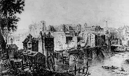
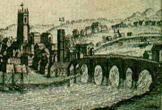
We see it again in a small detail from a view of Chester (above) which was published in the London Magazine in 1753 and, more clearly, in this interesting sketch by historian Randle
Holme
III (1627-1699).
Just
a year
after
the
widening
of
the
Old
Dee
Bridge
in
1826,
the
foundation
stone
of
a second
river
crossing,
the
new Grosvenor
Bridge was
laid
by
the
Marquis
of
Westminster.
Today, the picturesque bridge stands devoid of towers, drawbridge and portcullis,
but remains a busy bottleneck throughout the day as- despite its 19th century
widening- it is still too narrow for two-way traffic, the flow being controlled
by traffic lights.
In the Spring of 1999 the carriageway was resurfaced and laid out to include
an advanced stop line for the benefit of cyclists. At
the same time a series of safety checks were made, which found that, after over
six hundred years of constant use, the ancient structure was coping very well
with modern traffic. These investigations also found evidence of a cobbled road
surface below the level of the present carriageway.
Millers
of
Dee
You
can
hardly
failed
to
have
noticed
the
great
weir
in
front
of
the
Old
Dee
Bridge.
As
far
as
we
know,
this
was
constructed
around
the
year
1093
on
the
orders
of Hugh
Lupus,
first
Earl
of
Chester,
to
supply
power
to
his
corn
mills
which
were
situated
where
you
see
the
small
modern
generating
station
at
the
north
end
of
the
bridge.
It is the oldest surviving structure of its kind in Britain.
 In
earlier
times,
the
river
seems
not
to
have
been
navigable
all
year
round,
for
the
Romans
had
to
haul
the
bricks
and
tiles
produced
at
their
industrial
centre
at Holt overland
from
Heronbridge
some
of
the
time.
This
was
later
to
change: "The
river
of
Dee
was
drawn
unto
the
said
cittie
with
great
charge
by
the
said
Earle or
some
of
his
predecessors
before
the
Conquest,
from
the
anciente
course
it
held
before,
a
myle
or
two
distant
from
the
cittie,
and
a
passage
cut
out
of
the
rock
under
the
walls
of
the
said
cittie". In
earlier
times,
the
river
seems
not
to
have
been
navigable
all
year
round,
for
the
Romans
had
to
haul
the
bricks
and
tiles
produced
at
their
industrial
centre
at Holt overland
from
Heronbridge
some
of
the
time.
This
was
later
to
change: "The
river
of
Dee
was
drawn
unto
the
said
cittie
with
great
charge
by
the
said
Earle or
some
of
his
predecessors
before
the
Conquest,
from
the
anciente
course
it
held
before,
a
myle
or
two
distant
from
the
cittie,
and
a
passage
cut
out
of
the
rock
under
the
walls
of
the
said
cittie".
Apart from improving the navigation, this produced a fast-flowing deep watercourse ideal for supplying power to watermills, whose construction, together with the strengthening of the Castle and city walls, were one of the first acts of Chester's new Norman masters. Hugh also reserved the Earl's Pool (later the King's Pool ), next to the causeway, for his private fishing interests and granted the Abbot of St.Werburgh's Abbey tithes for a mill "this side of the bridge" and fishing rights. He also granted three score fisheries, known as stalls, above the weir to several of his dependants.
Under the Earls of Chester, the mills on the Dee constituted the manorial mills of the city (Northgate Street excepted) and the custom of Soke Rights was established, which compelled the citzens (excepting the occupants of the Abbey and other religious houses) to take their corn to the Earl's mills to be ground- a lucrative monopoly which realised a handsome profit, the mills being constantly busy. The millers who worked here would raise their fees from the common people by taking a quantity of grain from each sack, but were often accused of taking more than their legal due and violent disagreements were common, often involving the use of lethal weapons. For centuries after, to call someone a 'Miller of Dee' was considered a serious insult, implying as it did dishonest trading practices.
There was a jolly miller once,
lived on the River Dee,
He worked and sang from morn till night,
no lark more blithe than he
And this the burden of his song
For ever used to be-
"I care for nobody, no, not I,
If nobody cares for me" |
In
1237,
the
Crown
took
over
the
Earldom
of
Chester,
and
the
Dee
Mills
became
the King's
Mills,
becoming
extensive
and
increasingly
lucrative,
especially
when
sub-let,
as
for
example
in
1277,
when
the
master
mason Richard
the
Engineer, who
worked
upon
the Cathedral and Conwy
Castle,
obtained
a
12
year
lease
from
the
King
for
a
monopoly
on
the
Mills
and
fishery
of
the
Dee
for
the
huge
sum
of £200
per
year.
Richard
may
not
have
found
this
as
good
a
bargain
as
he
may
have
wished:
several
times
during
the
1280s,
the
mills,
weir
and
salmon
cages
suffered
severe
flood
damage-
at
one
time
putting
the
former
out
of
action
for
three
months.
By
1600,
when
Alderman Edmund
Gamull purchased
the
mills,
there
were
at
least
eleven
water
wheels
operating:
six
for
grinding
corn,
two
for
raising
water
to
the
Bridgegate
Tower
and
three
for
fulling
cloth-
that
is,
for
beating
new
cloth
to
cleanse
and
thicken
it.
If
you
would
like
to
know
more
about
how
these
operations
were
carried
out, George
Skene's description of
the
workings
of
the
mills,
written
in
1729,
makes
fascinating
reading.
"If thou hadst the rent of Dee Mills thou would'st spend it". Cheshire proverb concerning extravagence: 15th century
 The weir was the source of many problems, notably that it made made navigation of the full length of the river impossible and that it caused flooding to the lands upstream. It was thus the subject of numerious legal disputes. In 1608, for example, it was decreed that "one full third of the said Weyre be pulled down and the river there made open", but the interests of the wealthy mill owners would have suffered by this and the order was not carried out. Welsh landowners at the time were particularly incenced at this and threatened to march on Chester to do the job themselves. The weir was the source of many problems, notably that it made made navigation of the full length of the river impossible and that it caused flooding to the lands upstream. It was thus the subject of numerious legal disputes. In 1608, for example, it was decreed that "one full third of the said Weyre be pulled down and the river there made open", but the interests of the wealthy mill owners would have suffered by this and the order was not carried out. Welsh landowners at the time were particularly incenced at this and threatened to march on Chester to do the job themselves.
Just
after
the
end
of
the
Civil
War,
the
city
authorities,
concerned
with
the
declining
state
of
the
river,
ordered
that
the
weir
and
mills
should
be
demolished,
so
that
the
water
could
flow
rapidly
out
to
the
estuary,
sweeping
with
it
the
silt
that
was
continually
clogging
up
the
Dee's
channels. The following petition, dated April 1647, the first year after the city had been taken by the Parliament, was addressed to the House of Lords, and is preserved among its records:
"Petition of the Aldermen, Merchants, and Citizens of the City of Chester. The River Dee is choked up and made unnavigable by reason of the stone causey erected near the city, to serve the Dee Mills, which for many years has occasioned a great decay of trading, and frequent inundations on the Welsh side. The Commissioners of Sewers for these parts during King James's reign resolved that the causey should be demolished, but this resolution took no effect in regard of the power of those whose private interest in the mills was concerned. Petitioners pray that they might have an ordinance for taking down tne causey and mills, and that the materials may be used for erecting tide mills for the service of the city."
Like
so
many
local
authority
decisions-
down
to
the
present
day-
that
clash
with
private
interests,
no action was taken. Silting
continued apace
and
the
Dee
continued
to
be
the
source
of
much
local
anxiety. As late as the 1890s,
proposals were made to raise the height of the weir to prevent high tides from reaching the upper river- and even to build a second weir downstream- but, once again, nothing was done.
In
April
1895,
the
Dee
Mills,
seen
in
their
final
form
in
the
old
photograph
above,
were
purchased
by
the
Corporation,
only
to
sustain
serious
damage
a
month
later
in
the
last
of
a
long
series
of
fires,
after
which
they
were
closed. There
was
a
brief
revival
in
1902,
when
Messrs.
Rigby
of
Frodsham
Mill
temporarily
resumed
production
in
the
workable
remaining
portion
of
the
mill.
As
an
experiment
in
the
commercial
use
of
the
river,
they
carried
a
cargo
of
wheat
in
a
 Swedish
ship,
which
was
piloted
to
the
Mill
Wharf
and
successfully
discharged.
The
experiment
was
not
repeated,
however,
as
the
berth
against
the
mill
did
not
give
sufficient
depth
of
water
for
the
vessel,
which
had
to
be
moved
to
mid-channel
for
several
hours,
resulting
in
a
loss
of
valuable
time
between
the
tidal
high
waters.
Soon
after,
the
Dee
Mills
closed
for
good
and
demolished
after
more
than
8
centuries
of
continuous
service. Swedish
ship,
which
was
piloted
to
the
Mill
Wharf
and
successfully
discharged.
The
experiment
was
not
repeated,
however,
as
the
berth
against
the
mill
did
not
give
sufficient
depth
of
water
for
the
vessel,
which
had
to
be
moved
to
mid-channel
for
several
hours,
resulting
in
a
loss
of
valuable
time
between
the
tidal
high
waters.
Soon
after,
the
Dee
Mills
closed
for
good
and
demolished
after
more
than
8
centuries
of
continuous
service.
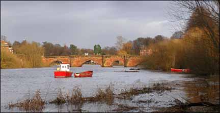
Left: the tranquil sight of the Old Dee Bridge and fishing craft viewed from upriver in late January 2008. Photograph by the author.
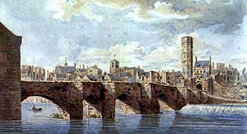
Above
is
a
fine
watercolour
by
the
matchless Moses
Griffith (1747-1819)
showing
the
bridge
before
it
was
widened.
The
Bridgegate
may
be
seen,
surmounted
by
a
tall
octagonal
water
tower-
of
which
more
later.
To
the
left
is
the
ancient
church
of St. Mary-on-the-Hill,
and
left
again
may
just
be
seen
the
cupola
of
the Shire
Hall,
sadly
demolished
along
with
the
rest
of
the
medieval Castle at
the
end
of
the
18th
century.
Chester's
original
power
station
was
built
in New
Crane
Street in
1895. It
still
stands- or at least part of its facade does-
having
been
saved
thanks
to
a
two-year
campaign
of
public
opposition to a proposal to demolish it.
By 1911, a
dramatic
increase
in
demand
for electricity meant that the old steam-powered station had reached its maximum load so, in the same year, the City Electrical Engineer, S E Britton proposed a scheme for the construction of a hydro-electric station to be erected on the site of the recently-removed Dee Mills. His plans were criticised by the Chester & North Wales Architecural Society, who declared that the proposed building was out of harmony with the Old Dee Bridge.
The society offered their advice, suggesting that the building should be in a style more in keeping with that of the bridge and this was accepted. When the station was
opened
in
1913, it was the only hydroelectric plant in Britain that could handle both tidal and headwaters and the design was taken up in York in 1923. It ceased generating electricity in
1950,
but soon after extraction
of
water
from
the
Dee
was
authorised,
and
the
station
was
taken
over
by
the
West
Cheshire
Water
Board,
who
leased
it
to
the
council
in
1958,
from
when
the
former
hydro-electric
power
station
was
used
as
a
water
pumping
facility,
a
practice
which
continues
to
this
day.
Now go on to part II of
our story of the Bridgegate...
 Curiosities from Chester's History no. 17 Curiosities from Chester's History no. 17
- 1602 The Bubonic Plague broke out in St. John's Lane; 60 a week died;
no fairs held. Plague cabins were erected for the infected between the Watertower and the river.
- 1603 Queen Elizabeth I died and was succeeded by her cousin James VI of
Scotland, who became James I (1566-1625) of England. The High Cross was re-guilded.
Eight hundred and twelve persons died of the plague in Chester. Tudor House
in Lower Bridge street built (despite it saying 1503 above the door!)
- 1605 Thirteen hundred and thirteen out of a population of about seven thousand died of the plague in Chester; County Courts held
at Tarvin on account of it. Romney attributed a major cause of the pestilential
visitations to the "stagnant filthyness of streets, accumulated filth, neglected
public dunghills and open drains, due to the unpaved streets... (for example)
the puddle which had formed at the Eastgate which became so deep as to require the Mayor's orders to remove it".
- 1604 The most ancient of the Cathedral bells, inscribed "I sweetly tolling, men do call, to taste the meat that
feeds the soul"- dates from this year.
- 1605 The Plague very violent this year. It is said that not a house in the city was spared except
one in Watergate Street, which still stands (although rebuilt in 1862)-
and known as 'God's Providence House'. On its front it carries a beam from
the original building inscribed "God's Providence is Mine Inheritance". The Gunpowder Plot: Guy Fawkes arrested in cellars of Parliament and accused
of trying to blow up House of Lords during James I's state opening of Parliament.
- 1607 Great exertions made to have the Dee causeway removed (see above)
in order to prevent the overflow of the meadows, and that the river being
scoured, ships might pass again close to the city.
- 1608 Another Plague in the city. Extensive repairs carried out to the
City Walls between the Watergate and
the Watertower, apparently to a poor
standard, for within a year, they had again fallen into disrepair.
- 1613 Entry in city expenses: "Paid to Stammering Davye for clearing the
watercourse at Newgate, vi d." The plaque above the doorway of the Phoenix
Tower, carved by Randle Holme III, commemorating its use by the
Painters, Glaziers, Embroiderers and Stationers was put in place this year.
- 1614 Pocohontas, American Indian princess, marries
John Rolfe
- 1615 Moreton, Bishop of Chester died. "He was a great scolar and writer
against the Papists, but no great housekeeper, and therefore did not obtain
the love of the clergy..."
- 1616 Prince Charles (soon to be the ill-fated King Charles I) invested
as Earl of Chester
- 1619 William, Earl of Derby, had a Cockpit erected under the Cty Walls near St. John's Church. First Negro slaves in N. America arrive in Virginia
- 1620 The Pilgrim Fathers sail from Plymouth in
the Mayflower. Oliver Cromwell is denounced because he participates in the "disreputable game of cricket"
|
