
 he
building
of
the
weir contributed
greatly
to
the
gradual
silting
of
the
river
Dee-
from
early
times,
Chester
was
the
major
seaport
of
northwest
England,
trading
widely
throughout
Europe
and
supporting
a
thriving
shipbuilding
industry.
he
building
of
the
weir contributed
greatly
to
the
gradual
silting
of
the
river
Dee-
from
early
times,
Chester
was
the
major
seaport
of
northwest
England,
trading
widely
throughout
Europe
and
supporting
a
thriving
shipbuilding
industry.
By
the
reign
of
Henry
VII,
however,
it
was
impossible
for
large
ships
to
reach
Chester
and,
during
the
next
few
hundred
years,
other
harbours
further
along
the
Wirral
coast had
to
be
utilised, or new ones specially built,
as
the
waters
receded,
the
goods
being
unloaded
and
brought
to
the
city
by
flat-bottomed
boats
or
packhorses.
These
harbours, which were collectively known to mariners as the Chester Water, included
Blacon
Point, Burton, Shotwick, Neston, Parkgate, Dawpool, Hoylake and Meols.
Such
have
been
the
changes
that
no commercial ports now exist along the Dee coast of the Wirral Peninsula; the
first
three
of
these
are
now
inland while
the
site
of
the
port
of
Meols,
at
the
tip
of
the
peninsula,
is
now
lost
under
the
waters
of
the
Irish
Sea.
Rich
archaeological
finds
in
this
area
indicate
that
Meols
had
a
long
history
as
a
port,
predating
even
the
Roman
occupation
of
the
region.
Parkgate was,
for
a
period
in
the
18th
century,
the
North
West's
premier
port
for
trade
with
Ireland, Jonathan Swift, Handel and John
Wesley being
but
some
of
the
travellers
who
passed
through
here. It took ships up to 400 tons, some in the Atlantic trade, and it was from here that the troops of Oliver Cromwell embarked to create carnage in Ireland.
 Today,
Parkgate
retains
much
of
the
atmosphere
of
an
old
port,
and
its
many
visitors
are
often
surprised
to
see
the
old
harbour
wall
and
period
buildings
surviving
almost
completely
intact-
but
with
hardly
a
sign
of
the
river
that
brought
about
their
establishment. This remarkable 360 degree panorama dramatically illustrates the situation. See also our photograph of the place below...
Today,
Parkgate
retains
much
of
the
atmosphere
of
an
old
port,
and
its
many
visitors
are
often
surprised
to
see
the
old
harbour
wall
and
period
buildings
surviving
almost
completely
intact-
but
with
hardly
a
sign
of
the
river
that
brought
about
their
establishment. This remarkable 360 degree panorama dramatically illustrates the situation. See also our photograph of the place below...
One Emma Lyon, later Lady Hamilton (26th April 1765 –15th January 1815), best remembered as the mistress of Lord Nelson and as the muse of the portrait painter George Romney often visited
Parkgate
for
the
sea
bathing.. She was born Amy Lyon at nearby Ness near Neston, the daughter of a blacksmith, Henry Lyon, who died when she was two months old. She was brought up by her mother at Hawarden in North Wales.
Around
1730,
one Nathaniel
Kindersley, "supported
by
a
number
of
spirited
gentlemen" made
a
survey
of
the
estuary,
and
offered
to
restore
the
navigation
of
the
river
in
return
for
certain
dues
of
tonnage
and
the
profits
of
the
lands
which
would
be
recovered
from
the
sea.
An
Act
of
Parliament
was
passed
to
sanction
the
venture
in
1732,
the
first
turf
cut
in
April
1733,
and
the
waters
of
the
old
channel
were
turned
into
that
of
the
new
just
three
years
later.
Vessels
of
250
tons
could
come
up
to
the
city
for
a
short
time
after
that
with
no
difficulty,
and
in
1740,
The River
Dee
Company was
formed
to
maintain
the
new
cut.
Unfortunately,
a
clause
in
the
Act
stipulated
that
there
should
be "16
feet
of
water
in
every
part
of
the
river at
a
moderate
spring
tide",
but
opinions
varied
widely
as
to
what
was
meant
by
'moderate'
and,
as
a
result,
the
members
of
the
company
had
to
be
"urged
strenuously
and
often" to
fulfill
their
obligations.
The
new,
artificial
watercourse
was
much
narrower
than
the
old
natural
one
and
it
silted
rapidly
and
the
banks
deteriorated.
Arguments
and
litigation
dragged
on,
amazingly,
for
the
next couple
of
hundred
years,
until
1938.
The anonymous author of A Walk Round the Walls and City of Chester, published in the first years of the nineteenth century, described the situation so, "The act of parliament passed in 1735 gave a number of adventurers, incorporated as 'The River Dee Company', all the land on the north-east side of the channel; this much to the injury of the trade and port of Chester, induced them to conduct the river in a circuitous course, which nearly choaked the navigation; but, from a circumstance of a clause in the act, enabling trustees to seize possession of the land so taken, in case the channel should not be a certain depth, the citizens of Chester, are much indebted to the present laudable exertions of C. Dundas, Esq. and other patriotic gentlemen in the neighbourhood, who have recently adopted measures (agreeable to the intention of the bill) to clear the channel, which we hope may eventually prove a considerable advantage to the City of Chester; the Port of which will in stormy seasons be a haven, void of the great risk of the dangerous banks of Hoyle, which are in the course to Liverpool".
 This was sadly not to be and the
increasingly
uneconomic
and
absurdly
self-destructive
situation
contributed
greatly
to
the
rise
of
the
great
port
of Liverpool,
just
a
few
miles
away
on
the River
Mersey,
where
the
world's
first
enclosed
wet
dock
had
been
opened
as
early
as
1715.
The
building
of
the Manchester
Ship
Canal in
the
19th
century
took
even
more
trade
away
from
the
Port
of
Chester.
This was sadly not to be and the
increasingly
uneconomic
and
absurdly
self-destructive
situation
contributed
greatly
to
the
rise
of
the
great
port
of Liverpool,
just
a
few
miles
away
on
the River
Mersey,
where
the
world's
first
enclosed
wet
dock
had
been
opened
as
early
as
1715.
The
building
of
the Manchester
Ship
Canal in
the
19th
century
took
even
more
trade
away
from
the
Port
of
Chester.
Our
little sketch map
dramatically
illustrates
the
decline
of
the
once-mighty
River
Dee: Green indicates
the
riverbank
in
Roman
times, Brown is
land
reclaimed
from
the
marshes-
the 'Sea Lands'- Yellow shows
the
dangerous
and
constantly-shifting
sandbanks,
the Sands
of
Dee and
the
thin Blue line
indicates
the
modern,
greatly-reduced
course
of
the
river. A
number
of
the
ancient
harbours
are
also
indicated.
'The Bar of Chester'
A bar is a bank of sand, silt, etc., deposited at the mouth of a river and, in an estuary so much encumbered by sandbanks as the River Dee, the term applies, in particular to the West Hoyle Bank. The first reference to the Bar of Chester appears to be the one contained in a description of the district written in the 16th century by John Leland, the King's Antiquary. He states that "The Barre called Chester Barre, that is at (the) very mouth of the sandes spuid out of Dee Ryvor, is an 8 or 10 mile west south west from Hilbyri, that is, near the north coast of Flintshire somewhere between Prestatyn and a point two miles west of it."
Inelegant as is the expression used by Leland in modern ears, it aptly describes the continuous unrest of the shifting sands in the Dee Estuary.
It would appear that the position of the "Bar," as given by Leland, was not of the main sand-bank itself but of that part of it which extended across the channel used by ships and covered by sufficient water to allow them passage at the higher phases of the tides. The main sand-bank extended as far as Hilbre Island, adjoining to which the Horse and Rock Channels permitted an alternative access to the Dee by way of the Hoyle Lake, near the north coast of Wirral. At low states of the tide the sandbanks at the mouth of the Dee were uncovered, and this condition is well illustrated by an account of a disaster which occurred in l806 in which the King George packet with 165 passengers and the whole of the crew, with one exception, were lost. The boat set out from Parkgate for Dublin on the ebb tide in fair weather, but 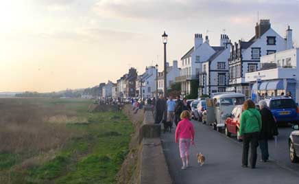 grounded near Hilbre and was soon high and dry. The only course was to wait for the next tide, and to pass the time, most of the passengers descended from the vessel and spent the day walking and running on the sand-bank. In the night a gale blew up, before the King George was fully afloat, and she was driven higher up the bank, and broke up.
Right: Parkgate, the best preserved of the lost ports of the River Dee. The quay wall (your guide is standing on it to take the photograph) and many old buildings survive intact but, as can clearly be seen, the water has long since vanished. Parkgate today is a wonderfully evocative place and a visit there is highly recommended- its ice cream, fish and chips, beer and view of the setting sun are unmatched. Learn more about it here.
In 1808 Hoyle Lake is described, on account of its lights, as a fit place for vessels bound up the River Dee "when towards evening they have not tide sufficient to go over Chester Bar".
The extent of the Bar in the direction of Chester appears to have been of rather elastic application. For instance, the tower and spire of the church of the White Friars in Chester was taken down in 1597 and an old chronicler laments this for a number of reasons, one being that it was "the only seaman's mark for direction over the Barre of Chester."
Although this spire was a particularly lofty one it certainly would not be visible from the neighbourhood of Rhyl, and a vessel would probably have to be a considerable distance up the estuary itself before the spire could be seen, owing to the high ground at Blacon Point intervening.
A lightship was formerly moored off the Point of Air ('Y Parlwr Du'), called the Bar Lightship. Dr. Crick, Bishop of Chester, wrote that, when he was chaplain to the Mersey Mission to Seamen, and in charge of the steam launch "Good Cheer" he paid regular visits to various lightships, and, on one occassion, when visiting the Bar Lightship, his boat ran aground on part of the Hoyle Bank.
The
Bridgegate
 Returning our attention to Chester, standing
opposite
the
end
of
the
Old
Dee
Bridge
is
another
of
the
ancient
entrances
through
the City Walls-
this
is
the Bridgegate,
designed
by the architect Joseph
Turner and
erected
in
1782.
On
a
marble
tablet
over
the
western
postern,
is
the
following
inscription:
Returning our attention to Chester, standing
opposite
the
end
of
the
Old
Dee
Bridge
is
another
of
the
ancient
entrances
through
the City Walls-
this
is
the Bridgegate,
designed
by the architect Joseph
Turner and
erected
in
1782.
On
a
marble
tablet
over
the
western
postern,
is
the
following
inscription:
"THIS
GATE
WAS
BEGUN
APRIL
MDCCLXXXII,
PATTISON
ELLAMES,
MAYOR,
AND
FINISHED
DECEMBER
OF
THE
SAME
YEAR,
THOMAS
PATTISON,
MAYOR.
THOMAS
COTGREAVE,
HENRY
HESKETH
ESQ.,
MURENGERS,
JOSEPH
TURNER,
ARCHITECT."
On
another
tablet,
on
the
south
side:
"THIS
GATE,
HAVING
BEEN
LONG
INCONVENIENT,
WAS
TAKEN
DOWN
A.D.
MDCCLXXXII.
JOSEPH
SNOW,
ESQ.
MAYOR.
THOMAS
AMERY,
HENRY
HEGG,
TREASURERS"
 At
the
time
of
the
Bridgegate's
completion,
news
came
through
of
the
victory
over
the
French
fleet
in
the
West
Indies,
and
on the
back
of
the
tablet
was
engraved:
At
the
time
of
the
Bridgegate's
completion,
news
came
through
of
the
victory
over
the
French
fleet
in
the
West
Indies,
and
on the
back
of
the
tablet
was
engraved:
"The
great
and
joyful
news
was
announced
this
day
of
the
British
fleet,
under
the
command
of
Admirals
Rodney,
Hood
and
Drake,
having
defeated
the
French
fleet,
in
the
West
Indies,
taking
the
French
Admiral
de
Grasse,
and
five
ships
of
the
line,
and
sunk
one.
The
battle
continued
close
and
bloody
for
eleven
hours".
(Joseph Turner's massive tomb is in the Overleigh Cemetery, Handbridge. Today it is shamefully neglected, virtually invisible among the undergrowth but here is a photograph of it by the author, taken about 20 years ago when it was somewhat more accessible...)
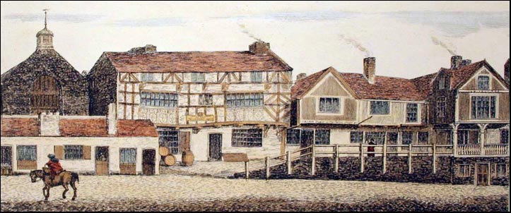
Turner's
arch
replaced
a
strongly-fortified medieval
entrance-
shown
here
in
an
etching
by George
Batenham-
comprising
a
massive
arched
gateway
with
two
strong
towers
on
either
side,
sometimes
known,
because
it
guarded
the
only
direct
approach
to
Chester
from
Wales,
as
The Welshgate.
On
the
gate's
west
side
once stood
a
high,
square-built
water
tower- not the one in our picture-
known
as John
Tyrer's
Tower which
was
constructed
in
1600
to
supply
water
pumped
up
from
the
river
and
distributed
through
lead
pipes
to
wooden
troughs
located
throughout
the
city.
You can see it in the old illustration of the bridge on the previous page.
William
Webb wrote,
about
1615, "This
bridge-gate,
being
a
fair
strong
building
of
itself,
hath
of
late
been
more
beautified
by
a
seemly
water-work
of
stone,
built
steeple-wise
by
the
ingenious
industry
and
charge
of
a
late
worthy
member
of
the
city,
John
Terer,
gent (also
a
lay
clerk
at
the Cathedral) and
hath
served
ever
since,
to
great
use,
for
the
conveying
of
the
river
water
from
the
cistern,
in
the
top
of
that
work
to
the
citzens
houses
in
almost
all
parts
of
the
city,
in
pipes
of
lead
and
wood,
to
their
no
small
contentment
and
commodity".
In
1601,
Gamull
became
a
partner
with
Tyrer
and
agreed
to
supply
water,
in
return
for
which,
it
was
alleged,
Tyrer
agreed
not
to
supply
water
to
those
citzens
who
did
not
deal
with
the
Dee
corn
mills.
The
tower
worked
well
enough
for
half
a
century,
until
being
badly
damaged
during
the
Siege
of
Chester,
and
was
eventually
demolished,
along
with
the
rest
of
the
old
Bridgegate.
(If
you
wish
to
see
for
yourself
how
Chester's
ancient
gates
would
once
have
appeared,
I
recommend
you
pay
a
visit
to beautiful Conwy along
the
North
Wales
coast,
where
the
massive
medieval
defences
remain in
situ,
including
a
complete
circuit
of
walls
and
one
of
the
most
spectacular
of
Britain's
castles).
The octagonal water tower we see in the Batenham picture above was built in 1692 by John Hadley and John Hopkins to replace the one destroyed in the war and this remained until the old gate was demolished in 1782.
The
gates
of
Chester,
with
the
exception
of
the Northgate,
which
was
the
charge
of
the
Mayor
and
citizens,
were
held
in serjeancy,
or
wardenship,
by
noble
families
who
were
responsible
for
maintaining
them
as
defences.
In
turn,
they
were
allowed
the lucrative privilege of
charging
taxes
on
goods
brought
into
the
town
through
their
gate.
 In
the
17th
century,
the
Bridgegate
was
in
the
charge
of
the Talbots,
Earls
of
Shrewsbury,
who,
when
in
Chester,
resided
in
the
splendid
timber
house
you
can
see
on
the
left
inside
the
gate
and
long
known
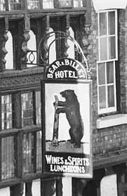
as
the Bear
and
Billet
Inn,
whose
interior
has been
sympathetically
restored
and
is
well
worth
visiting.
Notice
the
large
doors
at
the
top-
the
opening
to
the
loft
where
goods
were
stored
after
being
hoisted
up
from
the
street.
This
was
common
practice
at
the
time,
the
loft
being
the
part
of
a
house
deemed
most
free
of
damp,
vermin-
and
thieves.
The
windows
on
the
first
and
second
floors
extend
right
across
the
front
of
the
building
and
contain
1,620
quarries,
or
small
leaded
panes
of
glass. It
is
unsure
when
the
building
first
became
an
inn,
though
it
is
said
that
the
Earls
of
Shrewsbury
had
leased
it
to
an
innkeeper,
on
condition
that
a
suite
of
rooms
was
always
kept
available
for
the
Earl
and
his
family.
A
drawing
of
1820
shows
it
as
the Bridgegate
Tavern and
is
believed
to
have
acquired
its
present
name
soon
after.
In
the
17th
century,
the
Bridgegate
was
in
the
charge
of
the Talbots,
Earls
of
Shrewsbury,
who,
when
in
Chester,
resided
in
the
splendid
timber
house
you
can
see
on
the
left
inside
the
gate
and
long
known
as
the Bear
and
Billet
Inn,
whose
interior
has been
sympathetically
restored
and
is
well
worth
visiting.
Notice
the
large
doors
at
the
top-
the
opening
to
the
loft
where
goods
were
stored
after
being
hoisted
up
from
the
street.
This
was
common
practice
at
the
time,
the
loft
being
the
part
of
a
house
deemed
most
free
of
damp,
vermin-
and
thieves.
The
windows
on
the
first
and
second
floors
extend
right
across
the
front
of
the
building
and
contain
1,620
quarries,
or
small
leaded
panes
of
glass. It
is
unsure
when
the
building
first
became
an
inn,
though
it
is
said
that
the
Earls
of
Shrewsbury
had
leased
it
to
an
innkeeper,
on
condition
that
a
suite
of
rooms
was
always
kept
available
for
the
Earl
and
his
family.
A
drawing
of
1820
shows
it
as
the Bridgegate
Tavern and
is
believed
to
have
acquired
its
present
name
soon
after.
'J. H.', a contributor to the Cheshire Sheaf in December 1878 wrote of the old inn, "Not having been touched for many years, the front of the Bear and Billet has assumed a very dilapidated appearance, yet is undoubtedly rich in effect.
The painting of the timber is white, which seems to be unique, and certainly gives a very great contrast, especially in Chester, where we usually look for black timber. I suppose it is a matter o£ taste but I prefer the black, as a more suitable colour both for effect and endurance.
The glazing in the windows of the first floor is also very strange, reminding one of the patchwork counterpanes that are almost peculiar to Cheshire, the quarries are so very much varied.
 But I have heard that the front is to be restored and freshened up. I have no doubt that the old building will be tenderly handled under the architect employee to carry out this and the needful alterations to the premises".
The pub's character changed greatly during modern times- when your guide first visited it in the early 1970s, it was a lively (to say the least) venue popular with the motorcycling fraternity. The passing years found it becoming increasingly neglected and scruffy until, in September 1999, closed
its doors as a public house for the last time (or so we thought) having been taken over by
Benson's Bistro, whose former premises, the historic Gamul House- also in Lower
Bridge Street- was sold to a pizza company. The new owners, in their wisdom- and without planning permission- renamed the
old pub Benson's at the Billet- a decision that found little local
support. But then, in late 2001, it was announced that the ancient name was to be restored and the ground floor once again put back in service as a pub. Some three years later, the pub was indeed once more serving pints but the silly new name unfortunately remained. But, soon after, the long-troubled Billet passed into the care of the Isle of Man based Okell's Brewery and has thankfully once again become an excellent traditional pub offering decent food and a very wide choice of real ales and lagers from around the world.
Collectors of obscure Beatles information will be interested to know that John Lennon's (and his half-sister Julia Baird's) grandmother, Annie Jane Millward, was born in the Bear and
Billet in 1873 and lived there until she was in her 20s. Julia, a longtime former Chester resident, recalled, "Our great-grandfather (John Denbry Millward) and great-grandmother (Mary Elizabeth Millward nee Morris) lived there. Our great-grandfather was the clerk to the Earl of Shrewsbury, because of that he had the freedom to the city of Chester. During childhood, John and I used to spend a lot of time in Chester. We also used to come to Chester on the train from Liverpool as we always knew that Chester was the best place for clothes shopping. We used to go for lunch at Brown's and walk down by the river. Chester has always been in the family. We are the classic family that moved from Wales to Chester to Liverpool. John was very fond of Chester. We always thought Chester was the place to be, not Liverpool."
Annie married George Ernest Stanley, had seven children (the first two died in infancy) - one of whom was John's mother Julia. Annie died in 1941.
 The ancient Bear & Billet is thriving but many others have not been so fortunate- go here to
learn
about
the
many Chester
pubs
that
have
ceased to be. A
little
further
on,
on
the
corner
of Shipgate
Street,
and
prominent
in
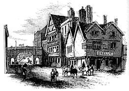
this
old
engraving,
is
just
such
an
ancient
tavern,
The Old
Edgar,
dating
from
around
1500,
which,
after
years
of
dereliction
was
restored
and
now
serves
as
a
private
residence. A
1905
postcard
advertised
the Edgar
Tavern,
as
it
was
then
called,
as
offering "refreshment
rooms
and accomodation
for cyclists". More pictures of it may be seen in our lost pubs gallery.
The ancient Bear & Billet is thriving but many others have not been so fortunate- go here to
learn
about
the
many Chester
pubs
that
have
ceased to be. A
little
further
on,
on
the
corner
of Shipgate
Street,
and
prominent
in
this
old
engraving,
is
just
such
an
ancient
tavern,
The Old
Edgar,
dating
from
around
1500,
which,
after
years
of
dereliction
was
restored
and
now
serves
as
a
private
residence. A
1905
postcard
advertised
the Edgar
Tavern,
as
it
was
then
called,
as
offering "refreshment
rooms
and accomodation
for cyclists". More pictures of it may be seen in our lost pubs gallery.
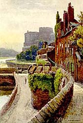
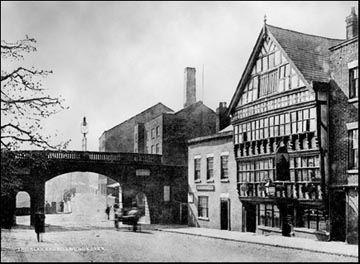
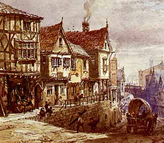
Left: a fine Victorian view of the bottom of Lower Bridge Street; the Bear & Billet Inn is on the right, beyond which is the Bridgegate leading to the Old Dee Bridge. With the exception of the looming presence of the Dee Mills beyond the bridge (which burned down in 1914) and, of the course, the absence of traffic, this attractive scene has remained largely unchanged to this day.
Shipgate Street was for centuries a principal entrance to the wharves of Chester's busy seaport and was a place of merchant's houses and sailor's inns until the silting of the River Dee brought about the destuction of the river trade here and its relocating to a new harbour constructed on what was once the bed of the receding river, its site continuing to be be called The Old Port today, even though this, too, has long ceased to be commercially viable. Access to the waterside from Shipgate Street was finally blocked, first by the construction of Harrison's gaol at the end of the eighteenth century and then by County Hall which opened on the same site in 1959. The ancient Shipgate itself was removed and eventually re-erected in Grosvenor Park, where it remains today.
By the 1970s, much of this area had become derelict and a report was drawn up by architect Donald Insall in 1978 which led, in the nick of time, to a programme of radical restoration. Many of the Victorian, Georgian and older houses in the area were restored and some fine new ones constructed and today this part of Lower Bridge Street and Shipgate Street are a delight and well worth visiting when you come to Chester.
There remains one notable exception to this, however, for across the road, on the corner of Duke Street, stands an appalling blot on the face of a beautiful old thoroughfare- an extremely large, ugly and insensitively-situated car showroom / office block. It stands on the site of an ancient group of buildings which went by the name of Old Coach Row which, as may be seen in the detail below from a painting by Louise Raynor (and also in our unmissable gallery of her work here) had steps between the changes in level as it descended steeply southwards towards the Bridgegate and River Dee. The dilapidated condition of the old houses eventually gave rise to the nickname, 'Rotten Row'. Some of the buildings had the characteristics of a true Chester Row, with a covered gallery above cellars entered from the street, whilst others boasted merely an arcade over a raised pavement. Most of the true Rows had gone by 1880 and, by the mid-twentieth century, the frontages had become utilitarian with occasional street-level arcading.
The site immediately to the right of St. Olave's Church was long occupied by a large stone-built structure, resembling a small castle, with a tall tower. This was the home of Richard the Engineer (Richard L'Engenour), the master mason of Chester Castle and, around 1277, the builder of Flint Castle. He was leaseholder of the lucrative Dee Mills just down the road, and was elected Mayor of Chester in 1305. Five years later, the Abbot of St. Werburgh's Abbey (now the Cathedral) commissioned him to build a new Choir.
In 1321, the old building was sold to one Robert Pares (or Praers) and henceforth became known as Pareas Hall- also recorded as Paris's Hall. When this ancient house was demolished is unknown. A building that arose on its site was utilised for some years as a brewery and maltings during the mid and late 19th century. In 1896, for example, the building is recorded as "Chester Northgate Brewery Co, malt kilns". The drawing below, dating from 1880, shows the brewery with St. Olave's on the left (behind a block of long-vanished stables) and Old Coach Row on the right.
In the early 1960s, all of the old buldings between St. Olave's Church and Duke Street were demolished and replaced by a vast and artless concrete showroom- illustrated here- built for the Grosvenor Motor Company and opened in 1962. At the time of writing, December 2010, it has stood empty for several years, boarded up and for sale. Perhaps it's time to knock the awful thing down and replace it with something more in keeping with the area?
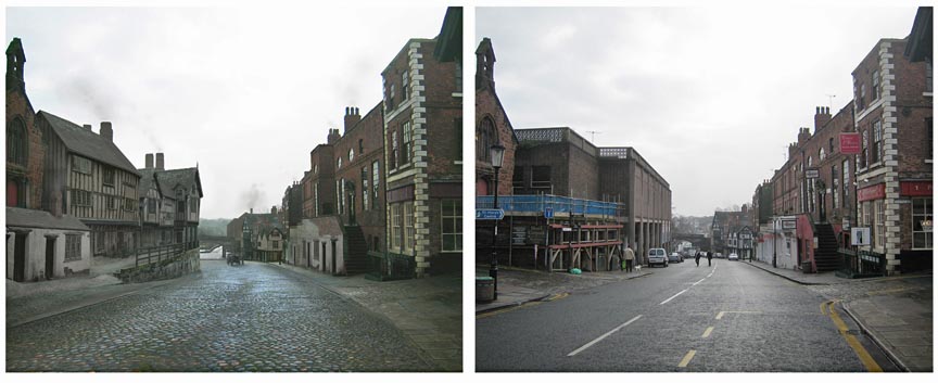
Above we see a wonderful image of Lower Bridge Street by the artist Martin Moss, showing the view down towards the Bridgegate as it was in the 19th century compared with today. St. Olave's Church is seen on the immediate left of both pictures but then things rapidly change for the worse as we compare the sadly-vanished Old Coach Row with the ghastly modern building on the same site. You can see a larger version of the older image, plus some other interesting ones, in our Louise Rayner painting gallery...
St. Olave's Church is a charming small sandstone building, standing high above the pavement- a last reminder of that old Row. St. Olave Haraldson was an 11th century king of Norway who helped to establish Christianity in his country. He died in 1030. The church was founded soon afterwards to serve a community of traders from the Norse settlement of Dublin who made this area, situated just outside the line of the Roman wall, their home. The church and its parish were always the smallest and poorest in the city and in 1841 the building was closed and the parish united with that of neighbouring St. Michael's. In 1858-9, Chester architect James Harrison restored the ancient structure to serve as the parochial Sunday school. Since then, it has served in a number of purposes, including aduly education centre, gallery and sale room. A few years ago, however, it was acquired by a Christian group and serves once again, under the name the Chester Revival Centre, in its 1,000-year-old role as a place of worship.
 Looking
up Lower
Bridge
Street,
you
can
see
at
the
next
junction St. Michael's
Church which,
standing
as
it
does
close
to
the
site
of
the
vanished
Roman South Gate,
or Porta
Praetoria,
gives
a
clear
indication
of
the
scale
of
the
Saxon
enlargement
of
the
fortress. There has been a church on this spot since the 10th century. Exactly when St Michael's was built is not known, although there are several references to the church towards the end of the 12th century. It was rebuilt in 1582 when thirty-one 'tymber treese' were obtained from Wrexham.
Looking
up Lower
Bridge
Street,
you
can
see
at
the
next
junction St. Michael's
Church which,
standing
as
it
does
close
to
the
site
of
the
vanished
Roman South Gate,
or Porta
Praetoria,
gives
a
clear
indication
of
the
scale
of
the
Saxon
enlargement
of
the
fortress. There has been a church on this spot since the 10th century. Exactly when St Michael's was built is not known, although there are several references to the church towards the end of the 12th century. It was rebuilt in 1582 when thirty-one 'tymber treese' were obtained from Wrexham.
During the Siege of Chester in 1644-6 the church was used as a prison. The Royalist prisoners kept there were "not to have meat, drink, candles, light or tobacco by especial order from the Commissioners, such were their cruelty". Perhaps because of the damage caused during this violent period, the Chancel of the church had become ruined by 1679 and was rebuilt. By 1708, the old wooden steeple and 'clockhouse' was said to be in a poor state and was replaced with a stone tower, surmounted by a cupola.
By the 1840s, the parish had been amalgamated with St Olave's but the interior of St Michael's had become dilapidated and the new tower declared unsafe. The South and East walls were also revealed to be in poor condition, so between 1849 and 1851 virtually the entire church was rebuilt under the supervision of James Harrison (who also, as we read above, was to restore St. Olave's ten years later). Apart from the North Aisle and Chancel roof, which date from the 15th century, most of what can be seen today is Harrison's work.
The church was de-consecrated in 1972 and, after being acquired by Chester City Council, became Britain's first Heritage Centre, opening in 1975. In March 2000, the City Council's archives- all the original documents which were held at the Town Hall- were transferred here and the old building is now the home of Chester History & Heritage, a matchless ambassador for our city and a superb source of information when you want to discover your Chester ancestors or find out about the history of Chester and District.
 Just across the road from St. Michael's
long stood
a
church
dedicated
to
the Irish Saint Bridget,
which
was
founded
around
the
year
797
by
King
Offa.
There
is
little
coincidence
in
the
situation;
probably
the
founders
made
use
of
a
ruined
Roman
gatehouse
that
formerly
formed
part
of
the Porta
Praetoria for
their
first
church. The
very
same
situation
seems
to
have
applied
at Holy Trinity
Church (The Guildhall) in
Watergate
Street,
a
Saxon
foundation
sitting
on
top
of
the
site
of
the
vanished
West
Gate
of
the
fortress,
the Via
Principalis
Dextra.
Just across the road from St. Michael's
long stood
a
church
dedicated
to
the Irish Saint Bridget,
which
was
founded
around
the
year
797
by
King
Offa.
There
is
little
coincidence
in
the
situation;
probably
the
founders
made
use
of
a
ruined
Roman
gatehouse
that
formerly
formed
part
of
the Porta
Praetoria for
their
first
church. The
very
same
situation
seems
to
have
applied
at Holy Trinity
Church (The Guildhall) in
Watergate
Street,
a
Saxon
foundation
sitting
on
top
of
the
site
of
the
vanished
West
Gate
of
the
fortress,
the Via
Principalis
Dextra.
St.
Bridget's
was
demolished
in
1825
to
make
way
for
a
road
leading
to
the
newly-constructed Grosvenor
Bridge.
Looking
at
the
site
today,
it
is
difficult
to
believe
that
a
church
stood
for
over
a
thousand
years-
preceded
by
a
great
Roman
gateway-
in
what
is
now
the
middle
of
the
busy
junction
of
Bridge
Street
and
Grosvenor
Street.
A
new
church
of
the
same
dedication,
designed
by the prolific Chester architect Thomas
Harrison (no relation to James),
was
erected
soon
after
close
to
the Castle,
but
this,
too,
was
demolished
during
the
1960s
to
make
way
for
a
traffic
island
as
part
of
the
Inner
Ring
Road.
Chester's
ancient
circuit
of
walls and
gates
are
constantly
monitored
by
its city
council
for
damage
and
movement.
In
the
Spring
of
2000,
it
was
noticed
that
the
parapet
of
the Bridgegate-
a
section
of
which
had
previously
been
pushed
to
the
street
by
vandals-
had
experienced
some
weakening
and
the
spandrel
of
the
arch
had
started
to
move
outwards.
Consequently,
a £40,000
programme
of
repairs
was
undertaken
involving
the
insertion
of
38
stainless
steel
rods
through
the
structure
and
16
horizontal
rods
drilled
through
the
parapet. So carefully was the work done that no trace of the radical repairs are visible to the casual observer.
Sadly, it appears that these remedial works proved inadequate as, not too long afterwards, the entire upper structure was encased in scaffolding and protective plywood. Remarkably, at the time of this latest update in July 2015, it remains that way all these years later!
And now it is time to rejoin the wall and amble on towards Chester Castle...
 1622 John Tyrer, who in 1600 had erected a Watertower on the Bridgegate
(see above), built a waterworks on the site of the Roman spring at
1622 John Tyrer, who in 1600 had erected a Watertower on the Bridgegate
(see above), built a waterworks on the site of the Roman spring at