|
  ontinuing
with
our
exploration
of
the
Kaleyards
area
of
Chester's
ancient
circuit
of
City
Walls,
we
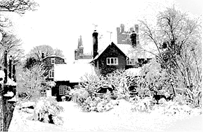
pass by the lovely Deanery Field and encounter
the
picturesque Deanery
Cottage on our right (illustrated
here
under
heavy
snow)
and
soon
the
atmosphere
changes
as
we
enter
the
environs
of Chester
Cathedral. ontinuing
with
our
exploration
of
the
Kaleyards
area
of
Chester's
ancient
circuit
of
City
Walls,
we
pass by the lovely Deanery Field and encounter
the
picturesque Deanery
Cottage on our right (illustrated
here
under
heavy
snow)
and
soon
the
atmosphere
changes
as
we
enter
the
environs
of Chester
Cathedral.
If
you
feel
the
need
to
take
a
picnic break
and
feel
some
green
grass
under
your
feet,
you
can
gain
access
to
the aforementioned venerable and charming open space through
the
wooden
gates
next
to
the
cottage. Access is also available from the end of Abbey Green, off Northgate Street.
The Deanery Cottage was long allowed to fall into disrepair but has recently been renovated and converted into student accomodation.
Moving
on,
our
attention
is
drawn
to
the
handsome
large
arched
window
of
the
house
standing
on
the
corner
of
cobbled Abbey
Street (just
visible
beyond
the
cottage
in
our
photograph).
Like
so
many
of
Chester's
fine
buildings,
this
house
is
a
product
of
centuries
of
change
and
alteration:
the
eighteenth
century
facade
fronts
a
seventeenth
century
house,
which
in
incorporates
an
even
earlier
stone
building.
It was
not
always
the
handsome
structure
we
see
today,
however.
In
fact,
by
1976,
when
it
served
as
eight
'bed
sitters',
its
condition
had
deteriorated
to
a
degree
that
it
was
thought
to
be
beyond
economic
repair.
But,
with
the
aid
of
numerous
grants,
in
1983-4
the
house
was
restored-
including
the
rebuilding
of
the
entire
north
gable
with
its
lovely
Gothic
arched
window-
and
converted
into
four
fine
apartments.
The Abbey Gateway and Square
 Continuing
on
down Abbey
Street,
with
its
elegant
terrace
of
Georgian
houses
along
one
side
and
the
Cathedral
Green
on
the
other,
we
soon
come
to the
lovely Abbey
Square,
which
was
laid
out as a speculative development
by
the
Cathedral
authorities
in
the
middle
of
the
18th
century
on
the
site
of, amongst other things,
the
old
brewery, bakehouse, stables
and
suchlike concerns that served the needs of the monastery, its many visitors and guests and, for a while, of the Cathedral church that succeeded it. Continuing
on
down Abbey
Street,
with
its
elegant
terrace
of
Georgian
houses
along
one
side
and
the
Cathedral
Green
on
the
other,
we
soon
come
to the
lovely Abbey
Square,
which
was
laid
out as a speculative development
by
the
Cathedral
authorities
in
the
middle
of
the
18th
century
on
the
site
of, amongst other things,
the
old
brewery, bakehouse, stables
and
suchlike concerns that served the needs of the monastery, its many visitors and guests and, for a while, of the Cathedral church that succeeded it.
The
Abbey,
and
later Cathedral,
precincts
had
always
been
independent
of
the
jurisdiction
of
the
City
and,
doubtless
much
to
the
irritation
of
the
civic
authorities,
all
manner
of polluting industries
were
carried
out
behind
the
protection
of
high walls and the
great
14th
century Abbey
Gateway (of which more below).
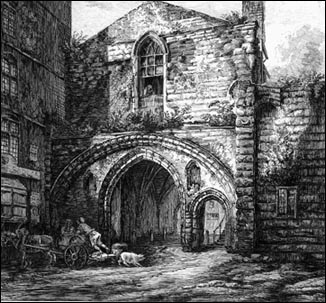
Right: the Abbey Gateway, an etching by George Cuitt (1779-1854)
In
addition,
the
Abbey
was
not
subject
to
the
extremely
restrictive
trading
regulations
of
the
town
and
'strangers'-
those
who
were
not
Freemen
of
Chester-
could,
as
long
as
they
paid
their
dues
to
the
Abbot,
trade
here
without
requiring
the
permission
of
the
Mayor
and
Burgesses.
The
stench
of
the
brewery
and
other
annoyances
would
long remain
a
source
of
complaint
to
the
townsfolk (and others- see below)
until
they
were
swept
away
when
the
area
was
transformed
into
Chester's
first
formal
square,
built
"after
the
London
fashion"
between
the
years
1754
and
1761-
although
the
western
terrace
(parallel
with Northgate
Street)
was
not
completed
until
the
1820s. This extract from a letter to the Dean & Chapter from the Archbishop of Canterbury in 1637 would seem to indicate that the area's former noisome activities had attracted official disapproval, and at the same time provides a description of the area before the coming of Abbey Square:
 "I am informed, that in yor Quadrangle or Abbey Cort of Chester, wherein my Lord the B'p of Chesters house and yor owne houses stand, the B'ps house takes up one side of the Quadrangle And that another side hath in it the Deanes house and some buildinges for singing men: That the third side hath in it one Prebende's house onelie, and the rest is turned to a Malthouse; And that the fourth side (where the Grammar Schoole stoode) is turned to a Comon Brewhouse, and was lett into lives by yor unworthie Predecessors. This Malthouse and Brewhouse, but the Brewhouse espetiallie, must needes by Noise and smoke and filth infinitlie annoy both my Lord the B'ps house and your owne, And I doe much wonder that any man of Ordinarie Discretion should for a little trifling gayne bring such a Mischiefe (for less it is not) uppon the place of theire owne Dwellinge.” "I am informed, that in yor Quadrangle or Abbey Cort of Chester, wherein my Lord the B'p of Chesters house and yor owne houses stand, the B'ps house takes up one side of the Quadrangle And that another side hath in it the Deanes house and some buildinges for singing men: That the third side hath in it one Prebende's house onelie, and the rest is turned to a Malthouse; And that the fourth side (where the Grammar Schoole stoode) is turned to a Comon Brewhouse, and was lett into lives by yor unworthie Predecessors. This Malthouse and Brewhouse, but the Brewhouse espetiallie, must needes by Noise and smoke and filth infinitlie annoy both my Lord the B'ps house and your owne, And I doe much wonder that any man of Ordinarie Discretion should for a little trifling gayne bring such a Mischiefe (for less it is not) uppon the place of theire owne Dwellinge.”
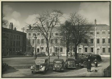
Left: an evocative view of Abbey Square sometime in the 1950s by the great Liverpool photographer Edward Chambré Hardman. All that has changed since is the cars!
The Bishop of Chester at that time, Bishop Bridgeman, would appear to have been in agreement, as he replied to Archbishop Laud, "ever since my being Bishop of this Sea (which is now almost 20 years) I have scarce had a month's health together, while I lived at Chester, by means of the smoake and the annoyance which came thereby"...
On
the
eastern
side
of
the
square,
which
was
initially
known
as Abbey
Court,
between
a
large,
free-standing
18th
century
house
and
the
Cathedral,
a
group
of
humble
sandstone
cottages
curiously
escaped
the
redevelopment
and
two
(they
formerly
stood
back-to-back
with
two
others)
remain with us
to this day.
They
were
built
in
1625
by
Bishop
Bridgeman
on
the
site,
and
incorporating
part
of
the
structure
of,
the
Abbey's
kitchens,
to
house
lay
clerks
of
the
Cathedral. They
continue
to
serve
as
private
residences
in
the
ownership
of
the
Dean & Chapter.
The
south
side
of
the
square
was
dominated
by
the Bishop's
Palace.
This
had
been
badly
damaged
in
the
Civil
War
and
so eventually, a century later,
between
1754
and
1757,
was
rebuilt.
Local author and guide Joseph
Hemingway
was
evidently
unimpressed
with
the
result,
describing
the
new
palace
as
being "as
destitute
of
magnificence
as
it
is
of
elegance". This second palace duly disappeared in its turn and its
site
is
now
occupied
by
a handsome Victorian pile housing a bank and offices. The
present
Bishop's
residence,
built
later
in
the 18th
century,
is
situated
behind
the
high
wall
on
the
opposite corner
of
Abbey Square.
You may notice the
causeways
of
weathered York
stone
laid
between
the
cobbles
in
the
square.
These are
known
as 'wheelers' and
were
thoughtfully
provided
to
allow
the
residents'
carriages with their solid wheels and primitive suspension
a
slightly smoother
ride. They
still
serve
their
purpose
very
well
for
today's
bicycles!
The
lower
part
of
the
pillar
in
the
middle of the central
grassy
area,
which
was
formerly
surrounded
by
iron
railings,
is said to have been
rescued
from
the Exchange-
the
predecessor
of
the
Victorian
Town
Hall
we
know
today-
in
nearby
Northgate
Street,
after it
was
destroyed
by
fire
in
1862.
Another version is that, a
hundred
years
earlier,
during
the
early
stages
of
the
building
of
Abbey
Square,
the
pillars
supporting
one
side
of
the
Exchange
were
found
to
be
weakening
and
so
were
removed
and
the
space
filled
with
a
row
of
shops
and
one
of
them
was
presented
by
the
city
to "the
gentlemen
of
Abbey
Square". The
grassed
area
where
it
was
erected
was
formerly
occupied
by
a
stinking
and
polluted
pond,
'the Horse
Pool' which,
in
1523
claimed
the
life
of
one
Roger
Ledsham, "Keeper
of
the
Great
Gate
of
the
Abbey
of
St. Werburgh" when
he
fell
in
it
and
was
drowned.
Could it have been that
the
proximity
of
the
Abbey's
brewhouse
played
some
small part
in
the
tragedy?
 The great Abbey Gateway, seen above in an early 19th century engraving by George Cuitt, that now links Abbey Square with Northgate Street and the Market Square dates from the fifty-first year of the reign of Edward III, 1377 (the last of his long reign), in which year he granted a licence for the monks to crenellate their abbey- in other words, to enclose it within high walls with fortified entrances. Some authorities say the gateway actually predates this event, being erected around 1300. The style of the gateway is Decorated, though late in that style. Walking beneath it will reveal its groined vault with ribs, in the centre of which still survives a sculptured statuette in bas-relief, probably a depiction of the patron saint of the Abbey, Saint Werburgh. Look out for the iron hinges where the great wood and iron-reinforced doors once hung. On the right hand side of the interior of the gateway, as viewed facing out to the Market Square, is an area of sandstone bearing deep grooves. This is where the armed monks guarding the portal would, in idle moments, have sharpened their weapons. The great Abbey Gateway, seen above in an early 19th century engraving by George Cuitt, that now links Abbey Square with Northgate Street and the Market Square dates from the fifty-first year of the reign of Edward III, 1377 (the last of his long reign), in which year he granted a licence for the monks to crenellate their abbey- in other words, to enclose it within high walls with fortified entrances. Some authorities say the gateway actually predates this event, being erected around 1300. The style of the gateway is Decorated, though late in that style. Walking beneath it will reveal its groined vault with ribs, in the centre of which still survives a sculptured statuette in bas-relief, probably a depiction of the patron saint of the Abbey, Saint Werburgh. Look out for the iron hinges where the great wood and iron-reinforced doors once hung. On the right hand side of the interior of the gateway, as viewed facing out to the Market Square, is an area of sandstone bearing deep grooves. This is where the armed monks guarding the portal would, in idle moments, have sharpened their weapons.
The upper part of the structure, with its 16-pane window in a Gothic arch, was rebuilt in 1800.
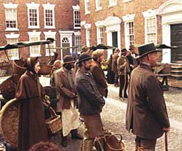
The Abbot's fair was held in front of the Abbey Gate for 3 days from the Feast of the Translation of St, Werburgh, the 21st of June. At Whitsun the Mystery Plays were performed by the members of the city's 25 companies of guildsmen. The earliest recorded performance of the plays was in 1566 or 1567 but they are believed to be much older than this. They were suppressed after the Reformation but revived in 1951 and are now performed by Chester's people every five years.
Just a little further down Northgate Street may be seen what remains of a secondary entrance into the precinct, the Little Abbey Gateway. Only the outer arch remains and it is unknown if a fortified gatehouse also once existed here. What does survive, noticed by virtually nobody, but as you will see should you step through the arch into what is currently a scruffy car parking area, is a small section of that once-formidable defensive wall, now built into the rear of the once-grand 18th century houses (now converted to shops and offices) in Northgate Street.
We invite you to view our gallery of images, old and new, of the two venerable Abbey Gateways here.
The anonymous author of the early 19th century work, A Walk Round the Walls and City of Chester, wrote of the Abbey Gateway, "which is a noble entrance of two Gothic arches, included within a round one of great diameter... over the arch of the gate-way is the Register's Office, consisting of large convenient rooms, surrounded with neat oak cases where the wills are kept, and two smaller rooms for the Register and his clerks. On the front of the gate are two niches; in one of which the image of Hugh Lupus was used to placed during the fairs."
 Of the square itself he wrote, "The Abbey Court is a neat square, within an obelisk and grass plot, enclosed by a neat iron railing; there are handsome modern-built houses on two sides; the Bishop's palace filling up the south side, which is a plain stone pile, built by Bishop Keene, in 1753, upon the walls of the ancient Abbot's house. The house in which the Dean resides, was lately built upon the walls of St. Thomas's Chapel, and is a commodious handsome building. The Prebends, Minor Cannons and Vicars Choral, have houses within the Abbey Court." Of the square itself he wrote, "The Abbey Court is a neat square, within an obelisk and grass plot, enclosed by a neat iron railing; there are handsome modern-built houses on two sides; the Bishop's palace filling up the south side, which is a plain stone pile, built by Bishop Keene, in 1753, upon the walls of the ancient Abbot's house. The house in which the Dean resides, was lately built upon the walls of St. Thomas's Chapel, and is a commodious handsome building. The Prebends, Minor Cannons and Vicars Choral, have houses within the Abbey Court."
The first
occupants
of
the
elegant
new
development
were
clergy,
local
gentry
and
private
families
of
means,
but
as
time
passed,
the
rising
class
of
'professionals'
such
as
doctors,
lawyers
and
architects
(including
the
celebrated John
Douglas who
worked
at
number
six
from
1860
until
his
death
in
1911)
came
to
dominate,
and
the
interiors
of
the
majority
of
the
old
houses
were
converted
into
offices
and
other
commercial
premises, a situation that endures to this day.
Nevertheless,
an
air
of
past
times
definitely remains-
this
photograph
shows
how
effectively
the
square
was
utilised by Granada TV
in
a
filming
of
a
scene
from
Thomas
Hardy's Far
From
the
Madding
Crowd- virtually all the producers had to do was to remove the cars and the TV aerials! (Our picture library has many more photographs of this event, should readers be interested).
During the Second World War, number six Abbey Square was requisitioned from architects Messrs Douglas, Minshull and Co. to become the city's ARP (air raid precautions) office. Circulars from the Home Office were continuously received here by the Emergency Committee, with instructions for setting up public shelters, school shelters, decontamination posts, first aid stations and the like. The ARP equipment itself was stored at nearby Folliot House in Northgate Street.
The Little Abbey Court
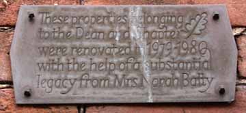 Making our way back up Abbey Street, the sharp-eyed may spot a small plaque about eight feet up on the wall of one of the houses that provides amusement for anyone acquainted with the long-running TV comedy, 'Last of the Summer Wine', for on it is inscribed "These properties belonging to the Dean and Chapter were renovated in 1979-1980 with the help of a substantial legacy from Mrs Norah Batty". Making our way back up Abbey Street, the sharp-eyed may spot a small plaque about eight feet up on the wall of one of the houses that provides amusement for anyone acquainted with the long-running TV comedy, 'Last of the Summer Wine', for on it is inscribed "These properties belonging to the Dean and Chapter were renovated in 1979-1980 with the help of a substantial legacy from Mrs Norah Batty".
Today, those who pass along Abbey Street may enjoy the sight of a verdant grassy lawn which covers the entire area between the Cathedral, the street and the City Walls, known as the Cathedral Green, where the venerable Mystery Plays used to be performed. But it wasn't always like this, and until the end of the 19th century, much of the area was covered by private houses and the area was known as The Little Abbey Court.
A matter of further interest is that that these houses were constructed from the remains of an important medieval establishment which passed from use with the suppression of the monastery- the Abbey Infirmary. This was used not only for the accomodation of sick monks but also for the lodging of those brothers who, by reason of age and infirmity, were incapable of taking part in the regular routine of the monastery.
Monastic infirmaries generally consisted of an accomodation hall, kitchens and chapel. In time, the central area of the great hall became an open courtyard from where the surrounding cells of the infirm monks could be accessed, as well as the kitchens and, by way of the slype or 'maiden's aisle', the east cloister of the abbey. An outer gateway gave access to the burial grounds and to Abbey Street.
 After the Dissolution, the chapel and other buildings became derelict and eventually disappeared but the old cells of the monks were added to and adapted into dwelling houses and these are clearly shown on period maps of the city. After the Dissolution, the chapel and other buildings became derelict and eventually disappeared but the old cells of the monks were added to and adapted into dwelling houses and these are clearly shown on period maps of the city.
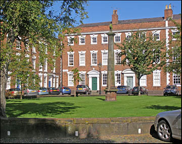
Left: Abbey Square today
The last remnants of the kitchens were demolished during improvement work by Dean Cholmondeley in 1809 at which time an old door was discovered and a dark passageway beyond. A witness at the event later recorded how "a light was procured and we went in at least 70 yards in the bowels of the earth, taking a direction apparently south-east. It extended further but we did not advance. Others, more daring, proceeded afterwards a greater distance. It was a regular footway. It is now covered with earth but the entrance to it is marked by a small archway and is about ten feet below the surface. it is to be lamented that this passage was not further explored under authority".
This mysterious passageway, seemingly of Roman origin, was later mentioned in Hansall's Stranger in Chester (1816) and in W T Watkin's great Roman Cheshire (1886), in which some later explorations of the relic are described in which it was said to be circular and at least ten feet in height. Dating from centuries before the establishment of the Abbey, it seems likely that part of the passageway came to light during early construction work and was incorporated into the cellars of the infirmary and later dwelling houses. Its situation today is entirely unknown, by this writer at least.
 There were five old houses standing in the Little Abbey Court- also known as the Abbey Close- when the the greater Abbey Court, some distance to the west, was renamed Abbey Square in the middle of the 18th century. As previously noted, they originated from the five lodgings of the sick monks and radiated from a central courtyard. A watercolour of 1875 shows some of the old houses, two-storied structures of red sandstone with upper floors of black-and-white work standing on the north side of the court. On the west side there is an ancient sandstone building, also of two stories, with mullioned windows capped by dripstone mouldings and the ground floor fronts show signs of niche or canopy works. There were five old houses standing in the Little Abbey Court- also known as the Abbey Close- when the the greater Abbey Court, some distance to the west, was renamed Abbey Square in the middle of the 18th century. As previously noted, they originated from the five lodgings of the sick monks and radiated from a central courtyard. A watercolour of 1875 shows some of the old houses, two-storied structures of red sandstone with upper floors of black-and-white work standing on the north side of the court. On the west side there is an ancient sandstone building, also of two stories, with mullioned windows capped by dripstone mouldings and the ground floor fronts show signs of niche or canopy works.
The residents of this secluded little group of houses in the 19th century were, to a considerable extent, connected with the affairs of the Cathedral and it seems likely that the same association applied to those residing here in earlier times- minor canons, organists and the like- and their names and occupations are recorded in the local directories of their day. One of these, a Mr Frederick Gunton, was a teacher of the Cathedral's choristers who would make use of an apple tree which grew in the courtyard to obtain 'instruments of chastisement at choir practise".
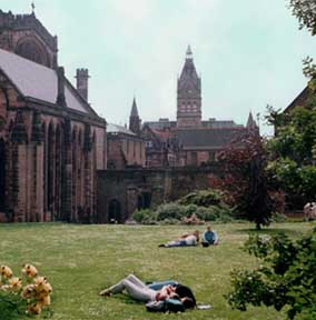
All this was to end in December 1884, however, when the entire area was demolished and the green lawns we see today were laid over the venerable foundations. The old apple tree survived the destruction, however, and was recorded as still flourishing in 1918. Our photograph shows the tranquil spot where the monk's infirmary and Little Abbey Court long stood, now being enjoyed by sunbathers.
Rejoining
the
City
Walls
and
looking
over
the
parapet,
we
see
a
tree-lined
area,
now
used
for
car
parking,
and
long
known
as The Kaleyards.
Descending
the stone
steps,
we
see
next
to
them
a
narrow
opening
in
the
wall,
equipped
with
a
stout
oak
door.
This
is
the Kaleyard
Gate and
is
a
smaller
and
less
ancient
affair
than
Chester's
other
gates.
In
1275,
the
third
year
of
the
reign
of
Edward
I,
the
Abbot
of
St. Werburgh's
Abbey
requested
permission
of
the
town
to
construct
a postern in
the
Walls
at
this
place
so
his
monks
could
avoid
having
to
go
round
via
the Eastgate to
attend
to their
vegetable
gardens
situated
outside
the
Walls.
In
these
troubled
times,
when
the
risk
of
armed
attack
by
Prince Llewellyn's
Welshmen
was
a
deadly
reality,
all
of the
city
gates
were
closed
at
curfew-
at
that
time
8.00pm-
and
at
times
of
danger.
Thus,
there
was
considerable
unease
at
the
Abbot's
request,
and
permission
was
only
eventually
granted
as
long
as
the
Abbey
assumed
responsibility
for
closing
their
new
gate
at
curfew
and
for
making
it
secure
during
times
of
crisis.
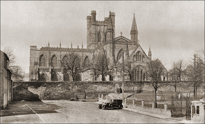
An evocative view of the Cathedral and Kaleyards from the early years of the 20th century
Some
time
later,
the
monks
were
allowed
to
make
yet
another
opening
in
the
walls, "where
the
swine
sty
used
to
be",
the
proposed
door "to
be
of
such
dimensions
that
a
man
on
foot
might
lead
a
horse
through
without
difficulty,
the
same
to
be
closed
in
time
of
war
should
the
safety
of
the
city
require
it."
It
was
also
ordered
that
a "drawbridge
should
be
put
across
the
fosse
at
the
Kaleyard
gate".
This fosse was
a
deep
ditch,
a
standard
feature
of
a
Roman
fortress,
which
ran
outside
the
north
and
east
walls.
Having
filled
up
over
the
centuries
with
the
accumulated
debris
of
the
town,
it
was
re-excavated
at
the
time
of
the
Baron's
war
in
1264
as
a
defensive
measure,
and
was
still
in
existence
in
the
late
16th
century,
when
it
appears
on Braun's Map,
but
has
since
entirely
vanished.
The
northern
section was
re-excavated
for
a third time
in
the
1770s
to
carry
the
bed
of
the
new
Chester
Canal.
(The
contractor,
expecting
to
have
to
excavate
through
solid
rock,
was
doubtlessly pleasantly-
and
profitably-
surprised
to
encounter
the
forgotten
Roman ditch).
Its
presence
at
the
Eastgate
was
first
shown
in
1860,
when
workmen
were
trying
for
a
foundation
for
a
new
building
just
outside
the
gate,
and
had
to
excavate
to
a
depth
of
30
feet
before
they
found
rock
at
the
bottom
of
the
ancient
defensive works.
Despite
the
convenience
of
the
new
openings,
it
would
appear
that
the
safety
of
the
monks
became
an
issue:
after
many
complaints
that
the
garden
was
frequently
robbed
and "the
monks
assailed
with
abuse",
the gardens were surrounded by a high stone wall and the
abbot
actually constructed two gates on the wall walk itself, to further hinder unauthorised access to the gardens. This of course, also prevented the law-abiding from passing by and he was indicted for obstruction in 1352. Nontheless, in 1414, Henry V granted the monks a licence to close these gates on condition that those who maintained the Walls, the Murengers, and those responsible for the city's defence in time of war were always allowed access.
 After
Henry
VIII's dissolution of
the
monasteries,
the
duty
of
securing
the
Kaleyard Gate
fell
to
the
Dean
&
Chapter
of
the
newly-created
Cathedral. The Swine
Sty
Postern survived
until
the
late
17th
century,
when
it
was
removed
during
repairs
to
the
Walls
following
the
end
of
the
Civil
War. After
Henry
VIII's dissolution of
the
monasteries,
the
duty
of
securing
the
Kaleyard Gate
fell
to
the
Dean
&
Chapter
of
the
newly-created
Cathedral. The Swine
Sty
Postern survived
until
the
late
17th
century,
when
it
was
removed
during
repairs
to
the
Walls
following
the
end
of
the
Civil
War.
During
this
conflict, Sir
William
Brereton,
leader
of
the
besieging
Parliamentary
forces,
observed
of
the
Kaleyard
Gate, "All
the
ports
made
up
(gates
sealed
up)
and
strong
guards
sett
upon
them,
some
of
them
within
pistoll
shott
soe
that
none
remained
open
but
one
little
sally
porte
whiche
is
betwixt
the
Phenix
Tower
and
the
Eastgate".
The
curfew
is
still
rung
from
the Cathedral belltower
at
8.45
each
evening and the
Kaleyard
Gate is locked
fiteen minutes later,
at
nine
o'clock, and
re-opened
at
sunrise.
It
is
the
only
remaining
city
gate
at
which
this
ancient
custom
is
still
observed
and
originated
in
the
Norman
law
of couvre
feu ('cover
fire'-
which
gave
rise
to
the
modern curfew)
when,
to
ensure
the
safety
of
the
largely
timber-built
town,
the
gates
were
closed
and
all
fires
had
to
be
extinguished.
A few years ago, the Dean and Chapter of the Cathedral, expressing concern that their staff may possibly be assaulted during the carrying out of their duties, did away with seven and a half centuries of tradition and discontinued the evening locking of the Kaleyard Gate. However, in June 2012, the ancient practice was resumed and carried out by a Cathedral Constable, an office that was formed as recently as December 2011 to look after the security of the Cathedral and its Estate.
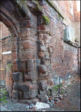
Mason's
Marks
 Passing
through
the
Kaleyard Gate
and
turning
around,
notice
the
great
eruptions
of
Roman
masonry
running
along
the
base
of
the
present
wall
to
our
left
and
note
also
the
variety
of
building
styles
evident
in
stonework
ranging
from
the
1st
to
the
20th
centuries.
You
may
rejoin
the
wall
here
either
by
re-ascending
the
steps
or
walking
up
the
ramp. Passing
through
the
Kaleyard Gate
and
turning
around,
notice
the
great
eruptions
of
Roman
masonry
running
along
the
base
of
the
present
wall
to
our
left
and
note
also
the
variety
of
building
styles
evident
in
stonework
ranging
from
the
1st
to
the
20th
centuries.
You
may
rejoin
the
wall
here
either
by
re-ascending
the
steps
or
walking
up
the
ramp.
Looking
around,
the sharp-eyed may
spot
carved
into
the
triangular
coping
an
anchor
and "692
feet".
This
marks
the
distance
between
here
and
the
Phoenix
Tower
and
represents
the
length
of
the SS Great
Eastern,
the
double-hulled
steam
and
sail
ship
which
was
launched
in
1858
and
used
for
the
laying
of
the
first
transatlantic
telegraph
cable
in
1866.
This
great
vessel,
which
was
originally
called The Leviathan, was
built
in
four
years
by the great engineer
Isambard
Kingdom
Brunel and
weighed
19,216
tonnnes-
several
times
the
size
of
the
largest
ships
of
the
time.
Her
vast
size
greatly
impressed
the
public
mind,
and
especially
that
of
one
Mr
Musgrave,
who
owned
the
timberyard
next
to
Cow
Lane
Bridge,
for
he
commissioned
William
Haswell,
a
master
mason,
to
record
the
event
on
the
wall
here.
This was done in 1858, the year the great ship was launched. Our photograph above shows the inscription still clearly visible, but noticed by few visitors, a century and a half later.
The Great Eastern was designed by Brunel and Scott Russell in 1852 and built at Millwall. She was ready for launching by October 1852 but it was not until January 1858 that she was actually afloat. Her cost was £732,000. Her greatest achievement was the laying of the first transatlantic cable and also similar communications cables in the Mediterranean and Red Seas. By
1874
the Great
Eastern was deemed
obsolete
and
she was sold at auction in 1886 for £58,000, ending
her
days
in
the
River
Mersey
as
a
floating
advertisment
for
Lewis'
department
store,
lying
at
anchor
with
music
hall
shows
and
circus
acts
on
board.
She
was
broken
up
on the seashore at
Tranmere
in
1889, where many of her iron plates may still be discovered, rusting away beneath the sand. Learn much more about her here.
 Other interesting marks
may be spotted by the sharp-eyed along
the
City Walls,
such
as
initials,
symbols
and
dates
which
appear
at
numerous
locations around the circuit.
These
were
inscribed
by
the
generations
of
masons
who
have
maintained,
repaired
and
rebuilt
the
walls
over
the
centuries-
Chester's Murengers.
The
earliest
examples
were
left
by
Roman
Centurions
in
charge
of
construction
gangs,
each
of
whom
would
have
been
responsible
for
completing
a
given
length
of
wall. None of these remain in situ but examples may be examined in the Roman Stones Gallery in the Grosvenor Museum. Other interesting marks
may be spotted by the sharp-eyed along
the
City Walls,
such
as
initials,
symbols
and
dates
which
appear
at
numerous
locations around the circuit.
These
were
inscribed
by
the
generations
of
masons
who
have
maintained,
repaired
and
rebuilt
the
walls
over
the
centuries-
Chester's Murengers.
The
earliest
examples
were
left
by
Roman
Centurions
in
charge
of
construction
gangs,
each
of
whom
would
have
been
responsible
for
completing
a
given
length
of
wall. None of these remain in situ but examples may be examined in the Roman Stones Gallery in the Grosvenor Museum.
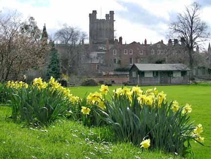
left: Chester Cathedral from the daffodil-fringed Deanery Field, photographed by the author in 2002.
Chester's
first
Infant
school
was
opened
in
the
Kaleyards,
following
the
forming
of
a
benevolent
society
set
up
for
the
purpose
in
1825,
under
the
direction
of
the-then new
Bishop
of
Chester,
Dr.
Charles Blomfield (in office 1824-48).
A
public
subscription
was
raised
to
pay
for
the
building,
but
when
this
proved
to
be
insufficient,
the
ladies
of
Chester
held
a
grand
bazaar,
which
raised £357,
and
the
new
school
opened
in
July
1826.
The
bazaar
profits
also
helped
the
society
to
extend
their
benevolent
activities
to
other
needy
parts
of
the
city.
The
schools
were
largely
supported
by
the
parents
of
each
child
attending
paying
one
penny
per
week. The old schoolhouse still stands here, albeit converted to a private residence.
On 14th August 1940, a Luftwaffe Heinkel HE III bomber attacked RAF Sealand, causing damage to some of the buildings. Three Spitfires from the nearby Hawarden Airfield were scrambled and attacked the enemy plane as it was making its third bombing run, bringing it down in a field near to Border House Farm in Bumper's Lane (close to where the recycling centre and Chester City FC's stadium is now). The crew all survived and were incarcerated briefly in cells at Chester Castle and spent the rest of the war as prisoners in Canada. As a morale (and fund)-raising exercise, the remains of the Heinkel were put on display in the Kaleyards, together with a money collection box.
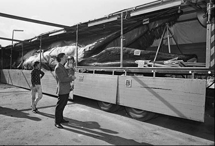 Reader Mike Wells wrote to tell us about an even stranger object that was once to be seen here: "I remember being taken on a school trip to see a blue whale. It was on display in the car park at the lower end of Frodsham Street, probably around 1957-8. The whale was a full size sperm, or possibly blue whale. It was mounted and preserved, on an articulated truck. How they managed to drive it around the streets of Chester I do not know. I remember it as part of an exhibition that filled the car park, from the Kaleyard Gate to the back of what became the Witches' Kitchen. I think I was then at the grammar school, although if it was before 1956, I would have been at Westminster Road School. Do you have any record or photographs of the occasion?" Reader Mike Wells wrote to tell us about an even stranger object that was once to be seen here: "I remember being taken on a school trip to see a blue whale. It was on display in the car park at the lower end of Frodsham Street, probably around 1957-8. The whale was a full size sperm, or possibly blue whale. It was mounted and preserved, on an articulated truck. How they managed to drive it around the streets of Chester I do not know. I remember it as part of an exhibition that filled the car park, from the Kaleyard Gate to the back of what became the Witches' Kitchen. I think I was then at the grammar school, although if it was before 1956, I would have been at Westminster Road School. Do you have any record or photographs of the occasion?"
Does anyone else remember seeing this remarkable sight? We've since learned that it was known as 'The Barnsley Whale' was also put on display around this time at the Pier Head in Liverpool. The much-missed DJ John Peel mentioned seeing it on his Home Truths radio show a few years ago. Here is a fascinating illustrated website about it..
Frodsham
Follies
Ahead
of
you
through
the
Kaleyards
is
the
busy
shopping
area
of Frodsham
Street,
formerly
known
as
Cow
Lane because for centuries cattle and other livestock would be driven
from the countryside down this street en route for the beast market that was held in Foregate Street. Later, this situation becoming inconvenient (a new generation of genteel residents and shopkeepers objected greatly to the disruption the herds produced- the proverbial 'bull in a china shop' was often a reality here!)- the
Cattle
Market was transferred to Gorse Stacks at the other end of Cow Lane,
where it thrived until
the
Even
earlier,
Frodsham
Street
was
the
commencement
of
the
Roman
road
which
ran
from
the
fortress,
along
the
line
of
modern
Brook
Street,
through
the
suburb
of
Hoole
(where
these
words
are
being
written)-
and
on
to
Frodsham
and
the Mersey crossing at Wilderspool (Warrington).
Much
of
the
route
remains
in
use
to
this
day-
although
some
sections,
as
at
the
Newton
Hollows
in
Hoole,
are
now
little
more
than
footpaths.
 This
slightly
fuzzy,
but
fascinating
'artist's
impression'
is from
the
remarkable Greenwood
Redevelopment
Plan of
1944-
when
this
country
was
still
enmeshed
in
the
Second
World
War-
which
advocated
demolishing
the
entire
west
side
of
Frodsham
Street
and
landscaping
the
area
to
create
a
new
city
park,
and
to
restore
the
area's
ancient
name, the Hop
Pole
Paddock.
How
delightful.
Notice
the
fountain
among
the
trees
in
the
centre.
You
can
also
see
the
familiar
Kaleyard
Gate,
stone
steps
and
ramp
on
the
city
wall
in
the This
slightly
fuzzy,
but
fascinating
'artist's
impression'
is from
the
remarkable Greenwood
Redevelopment
Plan of
1944-
when
this
country
was
still
enmeshed
in
the
Second
World
War-
which
advocated
demolishing
the
entire
west
side
of
Frodsham
Street
and
landscaping
the
area
to
create
a
new
city
park,
and
to
restore
the
area's
ancient
name, the Hop
Pole
Paddock.
How
delightful.
Notice
the
fountain
among
the
trees
in
the
centre.
You
can
also
see
the
familiar
Kaleyard
Gate,
stone
steps
and
ramp
on
the
city
wall
in
the
We
shall
encounter
a
number
of
other
bold
proposals
from
Mr Greenwood's
grand
scheme-
none
of
which,
for
good
or
bad,
were
ever
acted
upon-
during
the
remaining
course
of
our
stroll.
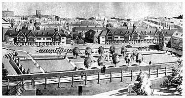
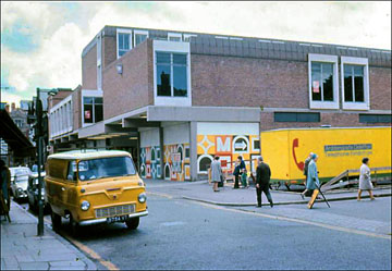
This ancient thoroughfare has undergone numerous changes in modern times. The entire west side (the left, looking from Foregate Street) was demolished to allow it to be widened in the first decade of the twentieth century. Among many businesses lost was the 17th century Raven Inn. (Learn more of it and the other vanished inns of Frodsham Street here.) In the 1960s, a stark shopping development known as Mercia Square (illustrated right) was erected which lasted a mere thirty years before being done away with and eventually replaced by the mediocre collection of shops that stand in this sensitive spot today. See some more photographs of it here.
 Yes, times
have
changed,
and
today's
planners
and
commercial
interests
too
often
seem
to
consider
the
open
spaces
within
and
around
our
city-
school
playing
fields,
allotments,
green
fields
and
meadows-
even
Roman amphitheatres,
for
heaven's
sake-
as
mere
'development
opportunities'
to
be
sold
off
and
built
upon. And
indeed,
in
early
2000,
we
were
concerned
to
hear
that
a
company
by
the
name
of Ethel
Austin
Shop
Properties had
sought
planning
permission
to
erect
a
two-storey
building
in
Frodsham
Street,
immediately
next
to
the
pedestrian
access
to
the
13th
century
Kaleyard
Gate,
a
location
described
by
the
city's
conservation
officer
as "an
exceptionally
sensitive
site". Councillors
were
warned
that
the
building
would
be "over
dominant",
would
virtually
fill
this
end
of
the
Kaleyards,
would
necessitate
the
removal
of
all
trees
and
shrubs
(and
no
replacement
landscaping
was
indicated
on
the
plans)-
and
that
it
"owed
nothing
to
local
architectural
styles". Yes, times
have
changed,
and
today's
planners
and
commercial
interests
too
often
seem
to
consider
the
open
spaces
within
and
around
our
city-
school
playing
fields,
allotments,
green
fields
and
meadows-
even
Roman amphitheatres,
for
heaven's
sake-
as
mere
'development
opportunities'
to
be
sold
off
and
built
upon. And
indeed,
in
early
2000,
we
were
concerned
to
hear
that
a
company
by
the
name
of Ethel
Austin
Shop
Properties had
sought
planning
permission
to
erect
a
two-storey
building
in
Frodsham
Street,
immediately
next
to
the
pedestrian
access
to
the
13th
century
Kaleyard
Gate,
a
location
described
by
the
city's
conservation
officer
as "an
exceptionally
sensitive
site". Councillors
were
warned
that
the
building
would
be "over
dominant",
would
virtually
fill
this
end
of
the
Kaleyards,
would
necessitate
the
removal
of
all
trees
and
shrubs
(and
no
replacement
landscaping
was
indicated
on
the
plans)-
and
that
it
"owed
nothing
to
local
architectural
styles".
The Chester
Civic
Trust objected
to
the
proposals,
describing
them
as
being "seriously
inappropriate".
They
noted
that
the
"overblown
scale
of
the
mock
timber
framing
on
the
building,
together
with
other
design
features,
were
objectionable
in
relation
to
the
City
Walls,
shops
and
listed
public
houses
on
Frodsham
Street",
that
the
narrowness
of
the
alley
that
would
be
created
between
existing
shops
and
the
new
structure
would
be
"oppressive
and
potentially
dangerous" and
that
it
would
block
the
only
remaining
viewpoint
outside
the
city
walls
from
where
one
can
see
the
Cathedral
and
Town
Hall
tower.
(and what a
view!)
Given
such
a
body
of
well-reasoned
objection,
councillors
had
little
difficulty
in
wisely
dismissing
the
application
which
was
duly
withdrawn
by
the
aspiring
developers-
who
then
promptly
appealed
to
Environment
Secretary
John
Prescott
on
the
grounds "that
the
council
had
not
decided
its
application"-
and
even
demanded
that
the
council
should
pay
the
costs
of
that
appeal!
By
the
time
this
came
about,
in February
2001,
the
developers
claimed
their
building
had
been "totally
redesigned" and
attempted
to
have
this
version
considered
by
the
government
Inspector.
He,
however,
declined
to
do
so,
explaining
that
an
appeal
must
be
based
upon
the original application
and
that
people
must
be
allowed
time
to
consider
and
comment
upon
the
revised
plans. Both
designs
were
the
handiwork
of
Liverpool-based
architect Craig
Foster, incidentally.
In
their
original
objection,
the
Chester Civic
Trust
had
concluded
that "this
is
a
visually
and
historically
important
site
which
needs
a
distinguished
design
sensitively
related
to
the
local
distinctiveness
of
its
setting". But
better
by
far,
we
say,
would
be
to
reconsider
the
good
Mr
Greenwood's
proposals
of
so
long
ago.
Not,
of
course,
that
we
would
advocate
his
large-scale
demolition
of
existing
buildings,
but
the
adoption
of
the
Kaleyards
as
a
much-needed
'green
lung'-
a
place
of
rest
and
recreation
in
the
heart
of
the
bustling
commercial
centre
of
our
city-
would
certainly
be
much
appreciated
by
residents
and
do
much
to
attract
visitors.
The
current
proposals
for
the
relocation
of
Chester's
smaller
car
parks,
such
as
that
currently
occupying
much
of
the
Kaleyards,
would
surely
add
to
the
viability
of
the
scheme.
 The
less-than-attractive
sight
from
this,
probably
the
most
visited
section
of
Chester's
City
Walls,
of
the
back
doors,
rubbish
bins
and
advertising banners
of
the
adjoining, deeply
mediocre Mercia
Square development
makes
it
additionally
important
that
the
remaining
areas
surrounding
the
Kaleyards
should
not
end
up
the
same
way.
A
new
park
here
would
be
an
ideal
location
for
concerts
and
an
open-air
market
too. The
less-than-attractive
sight
from
this,
probably
the
most
visited
section
of
Chester's
City
Walls,
of
the
back
doors,
rubbish
bins
and
advertising banners
of
the
adjoining, deeply
mediocre Mercia
Square development
makes
it
additionally
important
that
the
remaining
areas
surrounding
the
Kaleyards
should
not
end
up
the
same
way.
A
new
park
here
would
be
an
ideal
location
for
concerts
and
an
open-air
market
too.
But
what
were
we
thinking?
This
is
Chester
after
all.
By
the
end
of September
2001,
all
parties
had
kissed
and
made
up
and
Ethel
Austin's
re-design
had
been approved by
city
planners-
and
the ever-compliant
Civic
Trust
now described
it
as
"much
improved".
We
were
told
that
the
design
was
"in
keeping
with
the
mixed
architectural
character
of
Frodsham
Street
and
avoids
obscuring
views
of
the
cathedral".
We
also
heard
that
the
design
is
"supported
by
the
City
Centre
Conservation
Area
Advisory
Committee", whoever they may be.
But, by eight years later, Summer 2009, no sign of the controversial development had yet to be seen- and no surprise, for soon afterwards it was announced that Ethel Austin had gone into receivership! So that, hopefully, was the end of that.
But then, in October 2010, we heard the first of a deeply idiotic proposal to erect Chester's long-delayed new Market Hall, not somewhere on the vast area of dereliction behind the Town Hall as we had long been promised, but right here, on the Kaleyards! Architect's drawings forming part of consultation exercises taking place in January 2011 would appear to show a two-storey wood-faced modern structure with a plastic roof with a bridge walkway connecting it to the City Wall. We say 'appear to' because, for unknown reasons, no actual 'artist's impressions' of the building were made available for the public's enlightenment, merely aerial views of the site with the new building's outline imposed upon them. A skeletal side view of the new Market Hall's dimensions struck us as highly suspicious, appearing as it did to be no higher than the neighbouring shops in Frodsham Street..
Roman parade ground, medieval jousting croft and monks' vegetable garden, Victorian school playground- millennia of open-air usage, all apparently soon to end because a bunch of Dutch speculators in cahoots with a short-sighted local council don't want our market to to be rebuilt in the area where it has traded since Saxon times, in the vicinity of, you've got it- Market Square. According to aspiring developers ING, despite the pack of lies we were fed when they got their hands on it, the great area of land behind the Town Hall is now far too valuable to be wasted upon such trifles as theatres, bus stations, libraries- or Market Halls. All must be reserved for shops, shops and more shops. But not yet, for, intriguingly, rather than being put to good use, the land has just been laid out as a temporary public open space, St. Martin's Park, and will remain so for at least the next decade, awaiting the time when fat profits may once more be gleaned from it. Meanwhile, all of those much-needed community facilities must now be squeezed into what remains of Chester's open spaces such as the Little Roodee and here at the Kaleyards. Utter, utter folly.
But this, too, came to nought and, at the time of this brief update, March 2013, the talking shop regarding the Northgate Scheme goes on and on. Further dodgy developments, past and present, at the other end of the Kaleyards will be told of in our Eastgate chapter...
This remarkable
aerial
view-
a
detail
from
John
McGahey's
famous View
of
Chester
from
a
Balloon- shows
the
Kaleyards
and
their
surroundings
as
they
appeared
in
1855.
We
now
turn
our
attention
to
the
great
and
ancient
building
now rising
before
us: Chester
Cathedral...
Curiosities from Chester's History no. 7
- 1277 The King (Edward I) ordered that all in Cheshire that could spend £20 per annum should be made Knights. He establishes Chester as his base for the conquest of North Wales.
- 1278 The Old Dee Bridge was overthrown by a great flood, and the city was reduced to ruins by a dreadful fire.
- 1279 The Carmelites, or White Friars, established their house in Chester.
- 1281 December: Llywelyn, the last Welsh Prince of Wales, died in a skirmish with Lord Mortimer.
- 1283 (-1323) The building of Caernarvon Castle commenced. The 'Pied Piper of Hamelin'.
- 1290 Grant of land to the Carmelite (White) Friars enables them to build their friary in White Friars Lane.
- 1291 Thomas de Burchelles becomes fourteenth Abbot of St. Werburgh's (-1323)
- 1300 In Chester was received the final submission of the Welsh to the Sovereignty of England by Edward of Caernarfon, the first English Prince of Wales and later King Edward II, when the freemen of the Principality did fealty for their lands. Water from the springs at Christleton was first brought to the Abbey of St.Werburgh in earthenware pipes
- 1307 Edward I died and was succeeded by Edward II (1284-1327). Murage duty was introduced- a tax on goods entering Chester, which was used for the upkeep of the city walls.
- 1322 The Water Tower or Port Watch Tower, a defensive structure standing in the waters of the receding River Dee, was built by John de Helpston for £100- equivalent to around £250,000 in modern currency.
- 1323 William de Bebington becomes fifteenth Abbot of St. Werburgh's (-1349)
- 1327 Edward II was deposed by Parliament and brutally murdered "in a manner which could be seen by no man" (a red hot poker inserted into his back passage) at Berkeley Castle in Gloucestershire and was succeeded by his son as Edward III (1312-1377). The Aztecs establish Mexico City
- 1331 Chester's unique Rows are first mentioned by name in the city records- although they almost certainly existed long before this date.
- c. 1340 The Black Death kills a third of England's population. Within five years, it had arrived in Chester; crops rotted in the fields around the city because there were not enough reapers left to harvest them. Abbot William de Bebington died of this plague and was buried in the Abbey Choir.
- 1337 Beginning of the Hundred Years' War
- 1349 The Mayor of Chester, Bartram Northen, was slain by Richard Ditton, who was pardoned upon paying the sum of 150 marks. Richard de Seynesbury becomes sixteenth Abbot of St. Werburgh's (-1362) The Black Death kills a third of the population of England. Boccaccio: The Decameron
- 1353 Edward the Black Prince, Earl of Chester, and an armed force here to protect the justices against a 'commotion', caused by the dearness of provisions due to the effects of the Black Death. The citizens also complained of the cover afforded to robbers and villains in the now-overgrown Forest of Wirral. Edward requested his father to make an order to de-forest it, to which he agreed.
|